| EF3 tornado (NWS) | |
|---|---|
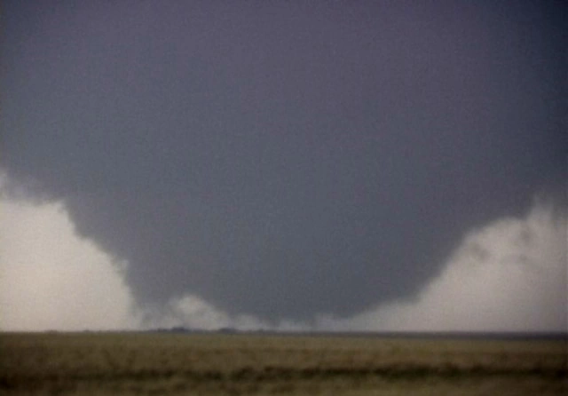
 The tornado shortly after attaining a maximum width of 2.6 miles. | |
| Date | April 17, 2009 |
| Times | 1944 - 2020 |
| Touchdown location | 1 SW Milan, Indiana |
| Highest winds |
145 mph (as indicated as tornado damage) 300+ mph (No damage suggests this intensity, however radar estimates show winds of 300+ mph) |
| Injuries | 10 |
| Fatalities | 3 |
| Damage | $10 million (2009 USD) |
| Areas affected | Ripley and Dearborn Counties, Indiana |
| Part of the Tornadoes of 2009 and the Tornado outbreak of April 16-20, 2009 | |
the 2009 Milan-Manchester-Guilford, Indiana tornado was a record-breaking, very intense and very large tornado which struck the communities of Milan, Manchester and Guilford in Indiana on April 17, 2009.
The tornado is tied as the largest tornado on record with the 2013 El Reno, Oklahoma tornado, peaking a maximum width of 2.6 miles wide. However, the tornado could've possibly peaked at a width of 3.0-3.5 miles.
The tornado killed 2 people in Manchester, and also killed a storm chaser just northeast of Milan.
The tornado saw little coverage in the media, and was mostly overshadowed by the extremely deadly tornado which struck Hartford City, Indiana that day.
Meteorological history[]
On the morning of April 17, a dangerous atmosphere for severe weather existed across the Ohio River Valley. Southeastern Indiana was placed under a 30% + hatched chance of tornadoes, some strong to violent.
Shortly after 1900, central Ripley County was placed under a severe thunderstorm warning as a storm intensified as it entered the high risk area.
A tornado warning was issued for central Ripley and Dearborn counties at around 1930, and the first of four tornadoes that this supercell would produce touched down at 1934 roughly 10 miles south of Pierceville.
This tornado would uproot several trees and later on receive a rating of EF-2. It is often disputed whether or not this is the actual touchdown location of the Milan-Manchester-Guilford tornado.
The second tornado of the four would touch down at around 1940, roughly 3 miles southwest of Milan, and would cause minimal EF-1 damage. The same funnel associated with this cell would touch back down at 1944, roughly a mile southwest of Milan.
The tornado -[]
Milan, Indiana -[]

A image taken of the tornado as it moved northeast of Milan.
The tornado touched down at 1944, roughly a mile southwest of Milan, it rapidly moved northeast, reaching a width of 0.6 miles wide while over Milan, producing EF0-EF1 damage in the town.
It caused roughly $600k in damages in Milan, most of it being roof or vehicle damage.

The tornado while it was undergoing rapid intensification in between Milan and Manchester.
As the tornado approached North Hogan Creek, it began to undergo a phase of very rapid growth, and reached a width of 1.5 miles by 1950.
This is where radar first indicated winds of 280-290 mph, and the NWS in Wilmington made the tough decision to issue a tornado emergency for Dearborn County as well as the northern Cincinnati suburbs at 1952.
At around this time, it hit a storm chaser's vehicle, killing them. By 1954, the tornado had reached a width of 2.1 miles wide, and was a absolutely "monstrous tornado" according to storm chasers who tracked it.
The tornado crossed North Hogan Creek at 1956 with a width of 2.3 miles, at the time the second widest tornado on record.
Manchester, Indiana -[]

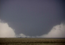
The tornado around the time of attaining peak width.
The tornado once again intensified as it neared Manchester at around 1959, reaching a width of 2.6 miles wide, little did many know, the 2004 Hallam tornado had just been overtaken by this tornado as the widest on record.
It hit Manchester at 2001 with a width of 2.4 miles, damaging every building in the town, and inflicting EF2-EF3 damage.
The tornado then proceeded to weaken, causing EF1-EF2 damage to a barn northeast of Manchester with a width of 2.2 miles, it crossed Flys Run at 2004 with a width of 1.9 miles.
Guilford, Indiana -[]
The tornado after crossing Flys Run.
The tornado after crossing Flys Run began to weaken considerably, and struck Guilford at 2014 with a maximum width of 1.5 miles, no longer a wedge tornado.
The tornado entered a area of very stable conditions and rapidly weakened, crossing Salt Fork with a width of 0.3 miles at 2019.
It finally lifted at 2020.
Aftermath[]
The tornado's original official width was 3.25 miles wide, due to a very wide area of crop damage around the time of peak width.
However, they downgraded the estimated width of 2.6 miles in May 2009, just .1 mile ahead of the 2004 Hallam tornado. This tornado stood uncontested as the widest tornado on record until May 30, 2013, when it was tied with the 2013 El Reno, Oklahoma tornado.
The tornado also originally received a rating of 310 mph EF5, the strongest estimated tornado on record at the time, however in Spring 2010 they downgraded this to a 145 mph EF3, due to no damage showing 300+ mph winds.