| Type: | Unknown |
| Active: | May 9-23, 2018 |
| Duration of tornado outbreak1: | 342 hours, 18 minutes |
| Maximum rated tornado2: | EF5 tornado |
| Highest winds | Unknown |
| Tornadoes confirmed: | 1,244 |
| Damage: | $56.9 Trillion (2018 USD) |
| Injuries: | Unknown |
| Fatalities: | 473 deaths, 67,084 injuries, 36 missing |
| Areas affected: | Unknown |
|
1Time from first tornado to last tornado | |
the 2018 Super Outbreak was a long lived and damaging event that started on May 9 and ended on May 23...in this period 1,244 tornadoes touched down all by a storm system 25 times stronger than the one that produced the 2011 Super Outbreak...
| Confirmed Total |
Confirmed EF0 |
Confirmed EF1 |
Confirmed EF2 |
Confirmed EF3 |
Confirmed EF4 |
Confirmed EF5 |
| 1,244 | 538 | 437 | 108 | 93 | 27 | 11 |
Meteorlogical Sypnosis[]
Moderate Risk in May 10 2000Z outlook
On May 8 a strong tropical depression formed off the Oregon coastline, early on the morning of May 9 the storm system moved on shore causing countless Severe Thunderstorm Warnings and even a few tornado warnings...a tornado warning was issued for Portland, Oregon around 4:45AM PDT with a confirmed tornado, a EF1 tornado was reported moving east at 25 miles per hour, the tornado caused roof damage to a few homes...at 6:00AM a EF2 tornado touched down in Northeastern Washington causing significant damage, only 5 tornadoes touched down on May 9...early on the morning of May 10 Weak tornadoes were reported in the mountains of Idaho, the largest only being 10 feet wide, the system gradually strengthened over Kansas during the afternoon hours of May 10 causing more damage and resulting in the NWS SPC issuing a Enhanced Risk of Severe Storms in the 1630Z outlook, in the 2000Z outlook the NWS SPC highlighted a small Moderate Risk over Kansas...a EF3 tornado touched down NE of Oklahoma City...in the 0100Z outlook the SPC highlighted a new High Risk over Northern Oklahoma and Central Kansas concerning a discrete line of supercells that had developed over the region within the hour, a 45% + Hatched threat of Tornadoes was highlighted over Extreme Northern Oklahoma and southern Kansas, PDS Tornado Watches were in effect from Northern Texas to Southern North Dakota around 0245Z, with the worst being PDS Tornado Watch 248 for Northern Oklahoma and Southern Kansas, here was the probability chart:
| Probability of 2 or more tornadoes | High (95%>) |
| Probability of 1 or more strong (F2-F5) tornadoes | High (95%>) |
| Probability of 10 or more severe wind events | Mod (40%) |
| Probability of 1 or more wind events > 65 knots | Low (20%) |
| Probability of 10 or more severe hail events | High (70%) |
| Probability of 1 or more hailstones > 2 inches | High (90%) |
| Probability of 6 or more combined severe hail/wind events | Low (<2%) |
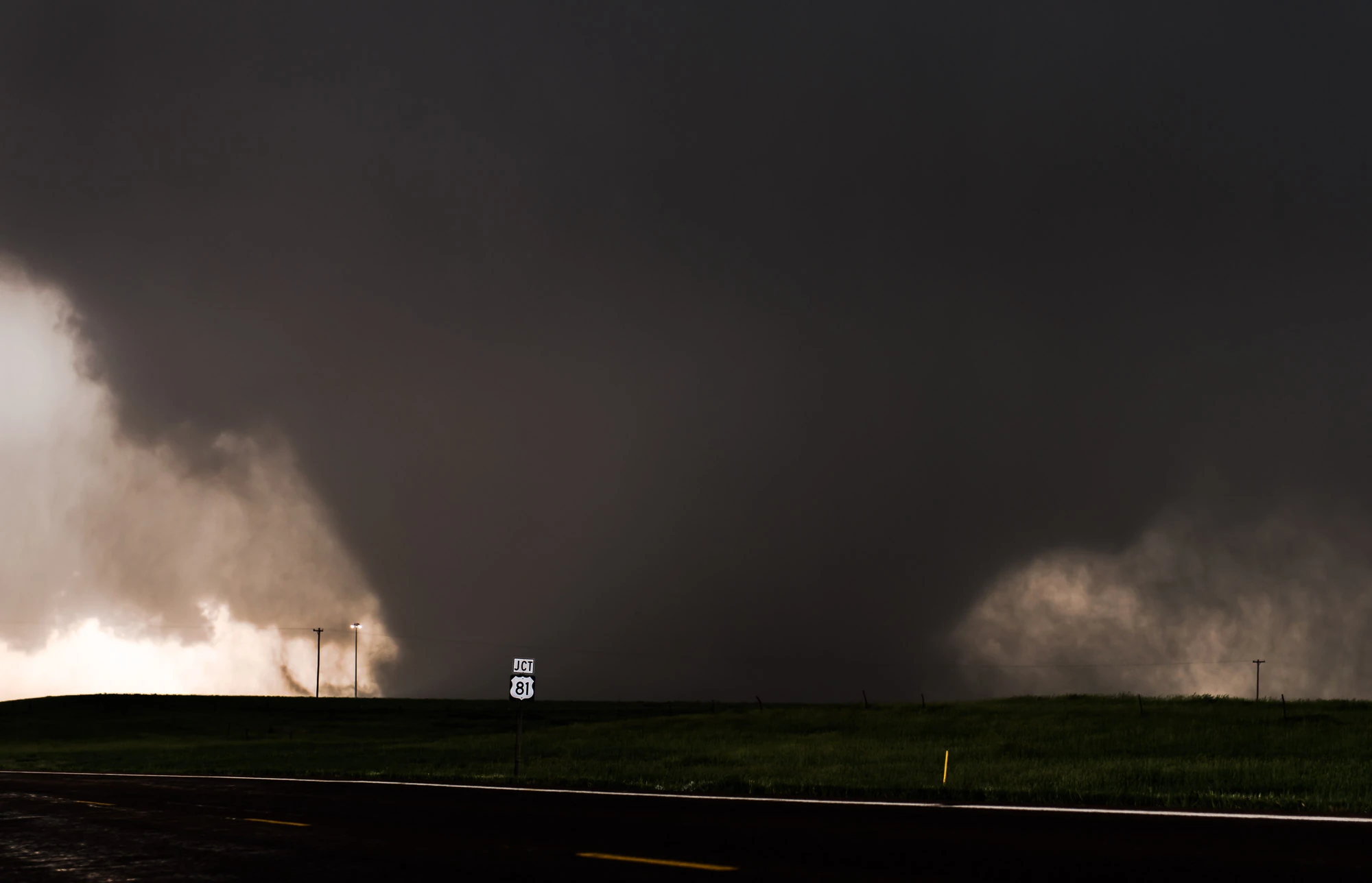
the first violent tornado of the outbreak, a EF4 near Shreveport, LA
on May 11 a high risk was issued for Northeastern TX, Southwestern AR and Northwestern LA...at 11:58AM a EF4 touched down near Shreveport, LA as a weak EF0...the tornado rapidly intensified into a EF4 by 12:03PM, the tornado moved into NW Shreveport, LA where much of the damage was in the EF3/EF4 range, the tornado lifted by 12:25PM...this is a wip...