Featured Article
2020 Stillwater Tornado is a featured article on the Hypothetical Tornadoes Wiki. This page was selected as a featured article by staff of the Hypothetical Tornadoes Wiki Community. This article was featured on June 1, 2020. The 2020 Stillwater Tornado won the "Most Realistic Article Award" during the HTW Awards Ceremony on June 1, 2020. |
| EF5 tornado | |
|---|---|
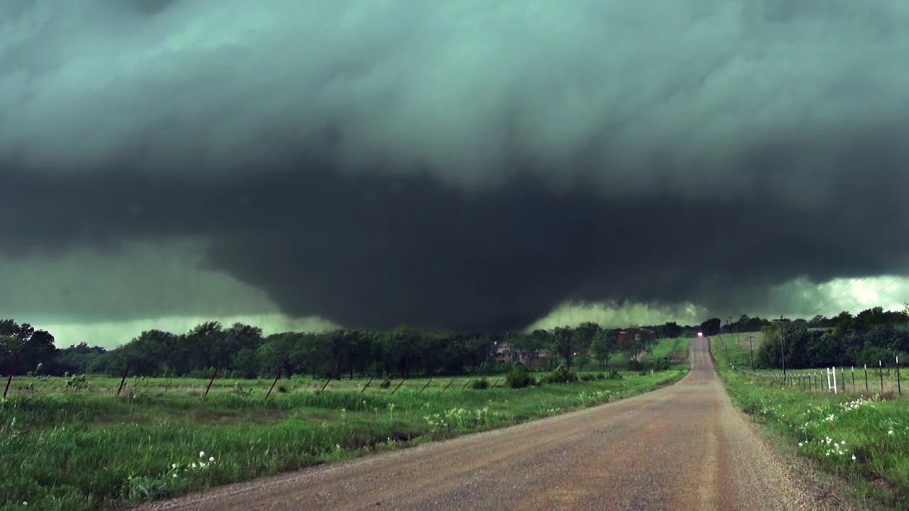 Tornado pictured at which time it inflicted its first instance of EF5 damage. | |
| Date | May 1, 2020 |
| Times | 4:10PM CDT - 7:02PM CDT (2hrs 52min) |
| Touchdown location | 4:10PM CDT |
| Highest winds |
275 MPH (Estimated) |
| Injuries | 1,752 |
| Fatalities | 333 (+6 indirect) |
| Damage | $1.8 Billion |
| Areas affected | Kingfisher County, Logan County, Payne County, Pawnee County, and Osage County |
| Part of the Tornadoes of 2020 | |
The Stillwater Tornado was an extremely powerful EF5 tornado that is remarkable for the extreme intensity it displayed, and holds the honour of having the highest estimated winds based on damage since the Jarrell F5 on May 27, 1997. The EF5 devastated rural communities in Central Oklahoma along a 109.3 mile path during the late afternoon/early Friday evening on May 1, 2020, killing 333 (plus an additional 6 indirectly) and injuring 1,752 while doing around 1.8 Billion $USD in damages. It is the deadliest Oklahoma tornado in history, surpassing the the 1947 Woodward tornado which killed 107 in Oklahoma plus an additional 74 in Texas.
The tornado first touched down at 4:10PM CDT in Kingfisher County, Oklahoma, roughly 4 miles north-northeast of Kingfisher, Oklahoma. It rapidly intensified into a violent tornado upon formation, wiping away a large metal structure at EF5 intensity, peeling away thick slabs of pavement, and grinding out a trench in the soil up to 3 feet deep. From here it continued ENE at around 45MPH, sweeping away ranch homes and tossing cars over a mile from where they originated, leaving them unrecognizable. It scoured away at I-35 before eventually striking the town of Stillwater. Here it did the most damage, damaging or destroying at least 5,000 buildings and killing 288. The tornado continued for many miles until finally dissipating at 7:02PM CTD after traveling 109.3 miles through 5 counties, lifting just east of Hominy, Oklahoma.
Meteorological Synopsis[]
The Stillwater Tornado was part of a much larger outbreak that produced 157 tornadoes across Tornado Alley on May 1 alone, along with an additional 125 tornadoes the next day that primarily affected the Midwest and Ohio Valley areas. The May 1st event is also the largest and most violent outbreak to affect the Central plains in a 24 hour period as well as the most violent outbreak documented in Oklahoma on record. With 21 violent tornadoes, of which 5 were EF5 it is the second most violent outbreak ever recorded; just behind April 3, 1974 which had 30 violent tornadoes, 7 of which rated F5.
On the morning of May 1, the Day 1 Convective Outlook issued by the Storm Prediction Center highlighted a High Risk over Central Oklahoma. A sharp dry line curved out of New Mexico and down through the high plains of West Texas. Ahead of the dry line was a troughing axis sweeping into West Oklahoma accompanied by confluence boundaries from storms the previous day. A rich, moist atmosphere settled in over the central plains later in the morning with a vast spread of 70+ dewpoints by 7:00AM CDT.
By noon, surface CAPE values began to exceed 5,000 J/kg, more than enough for tall thunderstorms with powerful updrafts. At the same time, a 100kt speed max in the jet stream was cutting down deep into the American Southwest.

Sounding data from the 1:30PM balloon sent up by NWS Norman. Note the large looping hodograph and potent CAPE.
At 12:59PM, the SPC issued its 18Z outlook which expanded the High Risk north into central Kansas as the warm front had traveled much further north and much more quickly than originally forecast. This also saw a further shift north of the slight risk for the Dakotas due to the heightened instability.

Special 1830z Convective Outlook update.
At 1:30PM, NWS Norman launched an unscheduled sounding to get a better read on the environment. Winds at the surface were found to be gusting in from the south/south-southeast at around 25MPH (40KPH), 55 to 60MPH (96KPH) from the south-southwest at the 850mb, and 90 to 100MPH (160KPH) from the southwest at the 500mb level. Effective helicity values were found in excess of 550 m2s−2 as a result. Thus, at 1:45PM CDT, the SPC updated the tornado probabilities in Central Oklahoma to 60% hatched. At the same time, a Potentially Dangerous Situation (PDS) Tornado Watch was issued for Central Oklahoma for long track, violent tornadoes and significant hail and wind. The SPC's issuance of the 60% tornado risk is only the second time a 60% probability of tornadoes has been issued by the SPC, the other time being April 7, 2006. At 2:00 PM, the first supercells erupted in the Texas Panhandle and Southwest Oklahoma. Within 15 minutes of development, numerous storms were issued Severe Thunderstorm Warnings for hail and severe gusts. At 2:32 the first tornado warning in Oklahoma was issued for the furthest southwest supercell; approaching Snyder.
Storm track and Development[]
The supercell that eventually produced the Stillwater EF5 formed with the initial wave of supercells, erupting off of a confluence boundary just north of Elk City, Oklahoma at around 2:00PM. Despite a lack of lift due to the dry line being positioned much further west, the extreme buoyancy (approaching 6500 J/kg), converging boundaries (a confluence boundary), and sweeping of an embedded trough axis in the upper levels generated the lift needed to light up a line of discrete supercells ahead of the dry line.
At 2:17PM, shortly after initiation, the supercell that would go on to produce the EF5 was severe warned for large hail and severe gusts northeast of Canute, Oklahoma, west-northwest of Foss in Custer County. Radar indicated 1.5 inch hail; however there were no spotters out in the area to confirm due to a lack of good road networks. The storm continued northeast from there, consistently severe warned as it strengthened.
At 2:33 PM, the first tornado warning was issued for the storm as it approached northwest of Clinton. Shortly afterward, storm spotters and law enforcement reported a trunk tornado under a clear updraft base. This first tornado would destroy a couple houses at EF3 strength, but no one would be injured or killed by it. As it tracked east-northeast, 3 more tornadoes would develop and dissipate. Of which were an EF0, an EF2, and a long lived EF3 cone that killed one and injured 15 as it passed through the town of Greenfield. 10 homes were destroyed at high end EF3 strength and cars were tossed over 100 yards. At 4:10PM, the fifth tornado of the supercell's life touched down 3.8 miles northeast of Kingfisher, Oklahoma.
Touching down on a river peninsula 3.76 miles northeast of Kingfisher, the tornado began as a short and narrow cone under a very low mesocyclone. From here it trekked to the north-northeast at around 45 mph. Just a mile from touch down the cone struck an oil rigging site, heavily damaging the machinery and metal structures. Damage to the site was rated EF3 in intensity, indicating a rapid growth in strength from the moment of formation. It also damaged another oil rig just down the road as well as tossing semi-truck trailers several hundred yards from their original location. This occurred as the tornado crossed Lemon Rd where moderate scouring of the pavement was noted; possibly from a micro-vortex within the tornado. From here spotters noted an increase in the size of the cone as well as substantial increase in earthen debris as it crossed into open field. Located in this field was also a few metal structures that collapsed and blew apart due to intense inflow winds. Later during the damage survey intense ground scouring was documented in this area.
Continuing east-northeast the tornado trekked across mostly open fields, impacting few structures and ripping deep rooted trees from the ground and tossing them long distances. A notable increase in apparent intensity was noted during this time as the cone evolved into a carosel of large sub-vortices dancing around the mesocyclone. Ground scouring became much more severe as well in which up to 18 inches of topsoil were peeled from the earth. The tornado grew larger, up to 700 yards wide as passed by the Winter Creek Site Reservoir. Here the first instances of EF4 damage were noted. Two well-built, manufactured homes were blown away, killing one. Continuing just less than a quarter mile from the Winter Creek site, another house was level and swept away. Damage here was noted as EF3 due to the structure being a manufactured double-wide home with minimal anchoring. Just down the road, another house across E730 Rd. was blown away. This home was of very poor construction, consisting of tin walls and a roof built upon a manufactured frame with no anchoring. One man was killed. Cars here were thrown from the location and stripped to their frames; the tornado continued east-northeast.
The tornado would again remain over open fields for the next couple miles, save for a single manufactured home that was completely swept away on N2990 Rd. Continuing from here the first instance of EF5 damage was noted as a single story, well-built, well-anchored house was swept away. At around 4:40 PM the EF5 tornado passed just 2 miles north of Crescent. As it crossed John Deere Rd/North Portland Avenue/Route 74 pavement was peeled from the ground, revealing bare soil beneath it. It is believed the extreme ground scouring leading up the the road allowed for the winds to work up under the asphalt; pulling it up into the updraft instead of just scouring it away. From here the 1 mile wide wedge continued ENE at 40MPH, mostly through open fields and rarely impacting any structures. One very well built house was completely swept away; debris scattered among the fields and trees as splinters. Deeply scoured cycloidal marks were noted in this area; perhaps from an extremely intense sub-vortex as the soil was plowed to a depth of a yard. The soil here was ripped up in chunks and plastered against trees and debris; turning the lush, green field into a muddy wasteland. Spotters noted a substantial darkening of the funnel at this time due to the extreme soil intake.
The wedge continued from here, widening to about a width of 2 miles as it crossed I-35. Cars caught here were thrown over a mile and obliterated. Pavement was pealed from the interstate and 3 people were killed. Spotters reported that at this point the entire mesocyclone was essentially on the ground as the black silhouette of the tornado hid underneath the low base which skirted the earth frequently. Survey efforts revealed that winds under the mesocyclone had likely reached EF1 strength and that it was key that spotters kept their distance. Evidence to support this was light scouring of grass due to the strong winds and pushed over trees in a circular pattern.
Trekking further east-northeast, the extremely violent wedge approached the outer reaches of Stillwater, Oklahoma at 5:22PM CDT. Along the way numerous rural settlements were completely swept away and 4 people lost their lives, and the black cloud of debris had further expanded to encompass 2.3 miles. According to residents of Stillwater, the tornado appeared as a black mass as it approached. The deafening roar the only hint of the monster that approached; many residents took cover in their shelters and basements.
Starting at Hidden Oak Dr. the tornado completely swept away the entire Boulder Creek subdivision of very well built and securely anchored houses. Sub-vortices dug out basements and swept away all flooring on solid slab foundations, leaving nothing but cracked and scoured concrete. The entirety of the Stillwater Golf and Country Club and the Golden Oaks Village were swept away. Every house was large and well-built. Reinforced concrete slabs were scoured, cracked, and shifted. Every house in the Pecan Hill Addition and Crosswinds subdivision were destroyed or swept away. Extreme cycloidal scarring was evident here, indicating this area was hit directly by a single, large sub-vortex over 400 yards wide. The Meadows and Tradan Heights subdivisions we completely wiped away with minimal debris left in the area. 52 people died here, buried among the rubble and skewered with splinters and shrubbery. Of note is that the survivors in this area were all underground where as all fatalties were above ground, indicative of how deadly the tornado was.
From there a Walmart Supercenter was flattened and scattered, killing 106. A large section of the store's steel frame was sheared from the foundation and twisted into a pile of scrap; pushed by the extreme winds into the parking lot where many cars simply "vanished". Every house in the Hillside Manor Addition were either damaged or destroyed. The Meridian Technology Center was severely damaged as several sections of the complex were collapsed and swept away. The roof was blown in and collapsed, and numerous interior walls were pushed in. Steel I-beams were twisted over 720 degrees and flattened against the foundation of the west wing, which was struck by an intense sub-vortex as indicated via distinct cycloidal scarring. Several homes in the neighboring Westbrook Estates were swept away and many more were destroyed.
Continuing east-northeast, the violent tornado destroyed and severely damaged many houses in the Berry Creek Addition. A few homes were completely flattened, and one was swept away. Further ahead it completely leveled a Quality Inn and flattened the Wicklow Professional Center. The I-beam frame of the Quality Inn was flattened too the foundation and mangled into a mess of steel by the extreme force of the tornado. Thirdly, numerous two story apartment buildings nearby were completely swept off their foundations or destroyed, many of which collapsed due to outdated construction methods that left them compromised in a violent tornado. From here the continued through numerous suburban divisions. Dozens of homes were completely swept away; some of which had their anchoring sheared off at the surface, and some in which the foundation was shifted and cracked. Starting just west-southwest of the of the West 6th Avenue and South Ridge Drive intersection, extreme cycloidal scarring began and travel east-northeast at around 125 MPH. Entire sections of pavement were peeled from the avenue as this intense sub-vortex cut through. At the same time, dozens of people were sheltering in the Westwood Elementary School in hopes that its brick construction would protect them from the storm. In the next 20 seconds, the entire school was flattened to the ground. The north wing was completely swept away by the sub-vortex, and the gym was flattened. 71 people died in the school of the 94 seeking shelter.
From here, the entire University and College district was struck directly by the core of the tornado. The entire Scott, Parker, Wentz Classroom building complex was destroyed. Extreme structural deformation was noted as the entire frame of the main building was twisted from foundation to roof by over 30 degrees. The underpinning system was entirely compromised, and the reinforced concrete foundation was shifted, cracked, and deformed. The Wentz Hall was entirely collapsed as the flat, rectangular surface area of the building caught the winds of the vortex. The building was twisted and pushed over as numerous chunks were ripped from its steel frame. The Scott Hall and Parker Hall buildings both suffered extreme damage as well. The outer wall were pushed in and the steel I-beam frames deformed, compromising their structural integrity. Continuing from there, the College of Human Sciences building was completely destroyed, as with the Life Sciences buildings, the International Mall, and the Edmon Low Library. Just east-northeast of here, however, a few hundred people have gathered inside the Boone Pickens football stadium, erroneously believing the concrete and heavily reinforced steel structure could protect them. Instead the entire football stadium was leveled to the ground. The outer steel frame was not built to protect from the winds and became heavily deformed as extreme forces blasted against it. The extreme volume of debris in the tornado further helped blow away the steel structure. Thirdly, the convex construction initiated the formation of a hyper-intense sub-vortex due to the funneling of wind into the lower levels. This tightened and stretched vorticity, exacerbating the damage as the steel I-beam frame deformed and collapsed. One concrete section of seats was pulled from the frame and tossed into Gallagher-Iba Arena, in which the building completely blew apart as wind from the tornado funneled into the structure's interior. Miraculously only 24 of the few hundred seaking shelter here died, though numerous critical injuries were inflicted on the survivors.
Continuing east-northeast, the tornado crossed over the North Duck St. and Hall of Fame Ave. intersection; flattening the APR Stadium and Bennett Hall. The sod of the football practice field is plowed into mud and the streets are scoured several inches. Cars are tossed hundreds of yards and obliterated along with the the buildings they land on. This would continue to be the story as the tornado tore through the rest of the city, flattening and sweeping away homes as it leaves the city behind. Further ENE it completely destroys the community of Maramec. From there it continued, noted by spotters having begun to contract into a black cylinder of violent upward motion as it approached Cleveland, Oklahoma. It tore through Cleveland at a width of about 1,000 yards killing 31. The vast majority of houses in the area were old and manufactured limiting damage ratings to the high end EF4 range, but surveyors are confident that the storm was still of EF5 intensity at the time of impacting the town.
After cutting through the center of Cleveland, the tornado began banking to the left, heading north. At the same time the wall cloud associated with the larger mesocyclone began to erode and decay as the tornado disappeared into the hail core of the parent supercell. The tornado finally dissipated just to the east of Hominy as the storm began to shift to the north along with the larger system. The supercell would go on to produce one more tornado before being consumed by a squall line that congealed from other supercells throughout the day. This tornado was rated a low-end EF4 after striking Barnsdall, Oklahoma, killing 6. In total the Stillwater EF5 tornado killed 333 people after traveling over 109 miles across northern Oklahoma.