 | |
| Type: | Tornado Outbreak Sequence |
| Active: | April 6-10, 2024 |
| Duration of tornado outbreak1: | 118 hours and 42 minutes |
| Maximum rated tornado2: | EF5 tornado |
| Highest winds | 210 mph (Jasper County, Mississippi-Oakman, Alabama EF5) |
| Tornadoes confirmed: | 153 |
| Damage: | 2.22 billion (2024 USD) |
| Injuries: | >2,000 |
| Fatalities: | 233 |
| Areas affected: | Unknown |
|
1Time from first tornado to last tornado | |
Tornadokid123 presents...
The Tornado Outbreak Sequence of April 6-10, 2024 was a prolific 5 day event which significantly impacted the Midwest and Southeast regions of the United States. Overall, this event was responsible for over 2,000 injuries, 233 fatalities, and approximately 2.22 billion USD in damages.
Meteorological Synopsis[]
In the early morning hours of April 6th, a rapidly developing intense low-pressure system was developing over the Midwest. A large scale trough was also developing behind this low-pressure system, and the Storm Prediction Center issued a Day 1 slight risk of severe weather for portions of eastern and central Nebraska, as well as portions of central Kansas, stretching into western portions of Oklahoma and Texas. A day 2 enhanced risk of severe weather was issued for northern and northeastern Arkansas, as well as southeastern Missouri. Finally, a Day 3 enhanced risk was issued for northeastern Louisiana, central Mississippi, western Alabama, and extreme southeast Arkansas. Additionally, a 15% risk of severe weather was issued for parts of Georgia and the Carolinas for April 9th.
April 6[]

The Day 1 outlook for April 6.
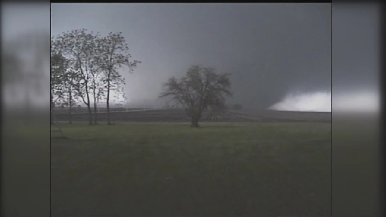
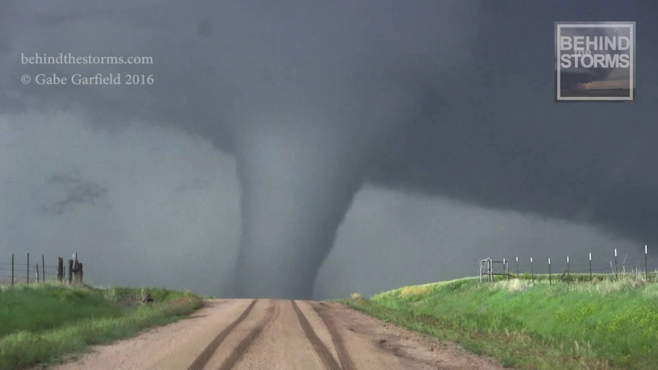
On the morning of April 6, a slight risk of severe weather was issued for portions of east-central Nebraska, central Kansas, and portions of western Oklahoma and western Texas, including a 5% risk of tornadoes for most of the area. CAPE values of 1000-2000 J/kg mixed with a weakening dryline were expected to hamper development of supercells that afternoon. However, throughout the course of the day, the dryline regained strength and instability increased to moderate amounts. Cells were expected to develop northeast of the Texas panhandle and move northeast through Oklahoma, eventually making their way into Kansas and Nebraska as the line of storms progressed. These storms were expected to be long-tracked, but the main threat was high straight-line winds. The NWS did acknowledge the possibility of “a strong tornado or two” in any of the forecasted states. At approximately 1:40 pm CDT, the National Weather Service issued tornado watch 163 for Hall, Childress, Collingsworth, Donley, Gray, and Wheeler counties in Texas, and Harmon, Jackson, Beckham, Greer, Washita, Kiowa, Roger Mills, Custer, Blaine, Kingfisher, and Dewey counties in Oklahoma. Cells began to develop rapidly at 2:30 pm CDT, with the first confirmed tornado touching down in rural areas of Hall County, Texas. Two strong tornadoes did touch down in Oklahoma later that afternoon, one of which grew to over a mile wide and moved west of Mangum, Oklahoma, causing high-end EF2 damage to a small farm outside of town, and killing one man in his car on a backroad. The supercells continued to move in a northeasterly direction and strengthened as this happened. 4 tornadoes were confirmed in Kansas past 4:30 pm CDT, 2 of which were rated EF2 and the other 2 rated EF1. One of the EF2 tornadoes which touched down was 0.8 miles wide and struck downtown Russell, Kansas, causing major damage and killing 2. Late in the evening, tornado watch 126 was issued for Washington, Burt, Douglas, Seward, York, Butler, Saunders, Lancaster, and Dodge counties in eastern Nebraska at approximately 6:15 pm CDT. At 6:49 pm CDT, a powerful lone supercell developed 20 miles southeast of Emerald, Nebraska, producing a weak tornado, which would eventually track over 75 miles and cause catastrophic EF4 damage to the small farming community of Blair, Nebraska after being weak for most of its lifespan, as well as growing to over 1.5 miles wide.
April 7[]

Day 1 outlook on April 7.
A rapidly strengthening mid-level jet stream of 70-90 knots and increasing CAPE value said of 1500-2500 J/kg, paired with helictites values of 200 m2 s2 made for a very strong setup centered over Arkansas and Missouri for April 7th, and conditions promoted significant tornadic activity. Although conditions were favorable for a moderate risk to be issued, once again, meager instability was expected to slightly hamper development of storms. Thus, an enhanced risk was issued, featuring a 10% hatched risk of tornadoes. Storms began firing up at approximately 5:30 pm CDT in southeastern Oklahoma and began producing tornadoes almost immediately, most weak and short lived as storms began to cross the Oklahoma border. The days first significant tornado touched down in rural Little River County, Arkansas, and tracked through the city of Wilton, causing major damage and earning a mid-range EF2 rating. No injuries or fatalities occurred with this tornado. Numerous large and destructive tornadoes would touch down later that night as the storms progressed and strengthened into northern Arkansas and southern Missouri. One long tracked stovepipe tornado raked through Clay county in northern Arkansas, garnering an EF3 rating, causing its most extreme damage in the town of Success, Arkansas. Later that night, around 8:00 pm CDT, a large EF4 wedge tornado decimated the rural community of Piggott, Arkansas, killing 12 and destroying nearly 75% of the town.
April 8[]


Day 1 outlook on April 8.
On April 8, conditions were ripe for a large scale severe weather outbreak. CAPE values soared at 3500-4500 J/kg, with helicity levels of around 350 m2 s2, dew points hovering near 65, paired with a powerful 80-100 knot mid-level jet stream and a strong upper level trough. These conditions formed and extremely unstable and dangerous atmosphere which heavily supported the formation of strong to violent long track tornadoes. At 12:22 pm CDT, the first of many tornado watches was issued for almost all of northeastern Louisiana and portions of western Mississippi. Discrete, powerful cells began to form just before 2:00 pm CDT in east Texas and southeast Oklahoma, moving quickly to the east. During the afternoon and into the evening hours of April 8, 4 violent tornadoes and 26 more rated EF2 or above touched down across Louisiana, Mississippi, Texas, Arkansas, Tennessee, Alabama, and Georgia. One of these tornadoes was a large and extremely violent EF5 wedge tornado which tracked from eastern Mississippi to western Alabama, decimating over 12 communities and killing 41. 3 EF4 tornadoes touched down on April 8 as well, 2 in Alabama and 1 in Mississippi which dissipated in southern Tennessee. The state of Texas saw an EF3 wedge tornado cause an explosion in rural Marion county after mangling a gas tank, causing a leak and eventually an explosion in an open field. Overall this was the costliest, deadliest, and most tornadic day of the outbreak sequence.
April 9[]


Day 1 outlook on April 9.
April 9th saw the activity weaken slightly and move east towards Georgia and the Carolinas. The mid-level jet stream weakened but still remained relatively strong at 65-85 knots. CAPE values from 1500-2500 J/kg Andy moderate instability, along with 180 m2 s2 helicity levels and dew points of 60-65 made conditions relatively favorable for moderate tornadic activity, mainly across Georgia and South Carolina, however a strong tornado or two was not out of the question for North Carolina and southern Virginia. Cells developed ahead of a dry line just past 6:30 pm EDT and produced weak tornadoes in western Georgia. As the cells progressed east-northeastward, strong tornadoes began to start dropping numerously across northeastern Georgia and South Carolina, 4 of which became intense and earned EF3 ratings. The most intense tornado of the day tracked 85 miles from Gainesville, Georgia to Starr, South Carolina and produced its most extreme EF4 damage in Falcon, Georgia, killing 22 in total. The outbreak carried into the morning hours of April 10, with the last confirmed tornado touching down in Scottsville, Virginia at 1:12 am on April 10, causing EF1 damage to 23 homes in town and injuring 4.
Tornado Table[]
| Confirmed Total |
Confirmed EF0 |
Confirmed EF1 |
Confirmed EF2 |
Confirmed EF3 |
Confirmed EF4 |
Confirmed EF5 |
| 153 | 47 | 54 | 29 | 16 | 6 | 1 |
Notable Tornadoes[]
Mangum, Oklahoma[]
This rather large and destructive tornado tracked through rural areas west of Mangum, Oklahoma during the afternoon hours of April 6th.
| EF2 tornado (NWS) | |||
|---|---|---|---|
| |||
| Duration | 3:16 pm CDT – 3:40 pm CDT | ||
| Intensity | 215 km/h (135 mph) (1-min) | ||

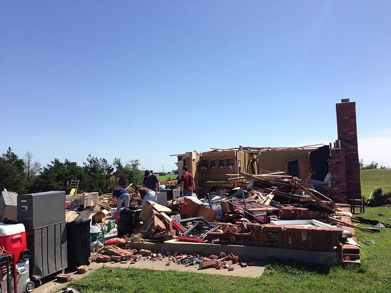
At 3:01 pm CDT, a lone supercell formed behind a squall line in rural Greer county, originally producing golf ball sized hail and 70 mph straight-line winds. However, the storm developed a very large wall cloud and began a textbook, tight rotation 25 miles southwest of the town of Mangum, Oklahoma. At 3:16 pm CDT, the storm dropped a weak EF0 rope tornado, which gradually gained size and churned slowly through Oklahoma farmland, moving north, on a path dangerously close to the town of Mangum.
The tornado, now 15 miles southwest of Mangum, produced high-end EF1 damage to a large dairy farm, killing over 100 livestock and partially removing the roof from a farmhouse. The tornado, which was now being tracked by a DOW, rapidly gained size and strength, growing to 1 mile (1.6 km) wide and a wind gust being unofficially recorded at 178 mph by the DOW, however, this was in an open field approximately 11 miles southwest of Mangum with no structures or trees being impacted. The tornado continued to track dangerously close to Mangum, maintaining a width of over 1 mile wide.
The tornado then leveled a farmstead just 3 miles west of town, indicative of wind speeds of 160-180 mph, however, tree damage near the structure was only indicative of EF1 strength, and the damage was thus rated high end-EF2. The mile wide tornado then took a sharp northwesterly turn, sparing the town of Mangum as the tornado reached a maximum width of 1.33 miles wide. The tornado weakened significantly, causing mainly tree damage for another 13 miles until dissipating in an open field at 3:40 pm CDT. Although it is widely acknowledged that this tornado likely reached at least low-end EF4 intensity, it didn’t impact nearly enough structures and stayed mostly in open spaces.
Blair, Nebraska[]
| EF4 tornado (NWS) | |||
|---|---|---|---|
| |||
| Duration | 6:49 pm CDT – 8:12 pm CDT | ||
| Intensity | 295 km/h (185 mph) (1-min) | ||


This extremely large, violent, long-tracked, and destructive wedge tornado devastated the small community of Blair, Nebraska during the nighttime hours of April 6.
At 6:36 pm CDT, a powerful isolated supercell which had formed behind the squall line currently tearing through eastern Nebraska and crossing the Missouri River into Iowa became tornado warned northeast of Pleasant Dale, Nebraska began to rotate extremely quickly and, at 6:49 pm CDT, dropped a weak cone tornado on the south side of Emerald, Nebraska. It tracked slowly northeast at EF1 intensity straight through downtown Emerald, causing moderate roof damage to several homes in subdivisions, and killing one woman after uprooting a tree onto her home. It was at this tome which a debris ball became evident on radar, and thus a PDS tornado warning was issued for Woodlawn, Nebraska, and surrounding areas northeast of Woodlawn in rural Lancaster county. The tornado continued through the north side of Emerald, causing low-end EF2 damage to a small subdivision, a bait and tackle shop, and a supermarket.
The tornado then widened to roughly 400 yards as it moved into the southwest side of Woodlawn, causing major structural damage to a Casey's gas station as well as leveling a dilapidated, unanchored home. The tornado began to gain speed as it carved right through Woodlawn, removing roofs from numerous homes, damaging cars and minorly debarking trees in the area. The tornado moved out of Woodlawn after killing 1 and churned through nearly 40 miles of farmland and crossing over into Saunders County. The tornado caused high-end EF1 to low-end EF2 damage to forests and small farms as it very narrowly spared the town of Davey, as it grew to 600 yards wide. As the tornado closed in on the small village of Memphis, a Tornado Emergency was issued for the village, as the tornado now wider than the town itself closed in.
The tornado caused its first small pocket EF3 damage of its path in Memphis, largely destroying 3 homes in a subdivision and partially debarking trees. Damage here was rated low-end EF3 with estimated winds of 140 mph. 4 deaths occurred in Memphis. The now 700 yard wide tornado weakened back to a low-end EF2 as it exited Memphis, taking a a turn slightly northward, narrowly avoiding the town of Wann, destroying several large outbuildings and removing a farmhouse's roof on a large dairy farm outside of town. The tornado continued to widen as it continued north-northeast, crossing the Platte River and moving in between the towns of Yutan and Venice. The tornado then clipped the Northwestern edge of Waterloo at mid-range EF2 intensity, now over 1,000 yards wide. Two homes had their roofs fully removed.
A new tornado emergency was issued for Washington, Nebraska, as it exited Saunders county and into Washington county. The small town of Washington was flattened at EF3 intensity as the tornado attained winds of 150+ mph. 2 unanchored homes were swept cleanly off of their foundations, killing 3. Trees were denuded and debarked, and caused severe damage to the Washington Fire Station, picking up a fire truck and throwing it over 50 yards. Virtually every structure in Washington was largely destroyed or majorly damaged. The tornado exited Washington after killing 7 and continued to widen and intensify. The tornado leveled a farm northeast of Washington and became violent, now at a width of 1.2 miles wide. It crossed highway 33, flinging cars and took a sharp northerly turn, on a path straight towards Blair. At this time, a Tornado emergency and emergency broadcast was issued for Blair.
BULLETIN - EAS ACTIVATION REQUESTED
TORNADO EMERGENCY
NATIONAL WEATHER SERVICE OMAHA NE
740 PM CDT SAT APR 6 2024
THE NATIONAL WEATHER SERVICE IN OMAHA HAS ISSUED A
*TORNADO EMERGENCY FOR...BLAIR IN WASHINGTON COUNTY
*UNTIL 810 PM CDT
AT 740 PM CDT...AN EXTREMELY LARGE...EXTREMELY DANGEROUS TORNADO WAS CONFIRMED 7 MILES SOUTH OF BLAIR...MOVING NORTH AT 50 MPH. TORNADO EMERGENCY FOR...BLAIR. THIS IS AN EXTREMELY DANGEROUS AND LIFE-THREATENING SITUATION. TAKE COVER NOW!
HAZARD...POTENTIALLY VIOLENT AND DEADLY TORNADO
SOURCE...TRAINED SPOTTERS REPORTED AN EXTREMELY LARGE, VIOLENT TORNADO 7 MILES SOUTH OF BLAIR.
IMPACT...THIS IS A LIFE-THREATENING SITUATION. FLYING DEBRIS MAY BE DEADLY TO THOSE CAUGHT WITHOUT SHELTER. MOBILE HOMES WILL BE DESTROYED. CONSIDERABLE DAMAGE TO HOMES...BUSINESSES...AND VEHICLES IS VERY LIKELY. CATASTROPHIC DAMAGE IS POSSIBLE.
PRECAUTIONARY PREPAREDNESS/ACTIONS...
TO REPEAT...A LARGE..EXTREMELY DANGEROUS...POTENTIALLY VIOLENT AND DEADLY TORNADO IS ON THE GROUND. TAKE COVER NOW! MOVE TO AN INTERIOR ROOM ON THE LOWEST FLOOR OF A STURDY BUILDING. AVOID WINDOWS. IF YOU ARE IN A MOBILE HOME...MOVE TO THE NEAREST SHELTER AND PROTECT YOURSELF FROM FLYING DEBRIS.
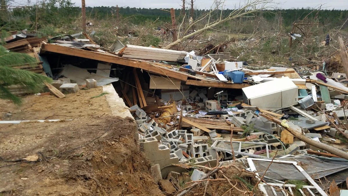
The tornado continued to move parallel to highway 33 and track directly towards Blair. Numerous farms along highway 33 were destroyed, including 2 which had their home completely swept away with wind-rowed debris. The tornado reached a maximum width of 1.8 miles wide as it collided violently with the town of Blair at 7:51 pm CDT. The town's water tower was toppled over and the tornado began producing catastrophic damage. It maintained EF4 intensity as it leveled or swept away every home it came into contact with. 6 well-anchored homes were leveled and largely swept away, and the tornado then hit the town's 3 car dealerships, leveling the main buildings and flinging cars well over 500 yards, most of which were severely mangled. Trees were stripped clean of their bark and reduced to bare stumps, and many had cars wrapped around them. Small patched of the town's main road were ripped up, and a bathtub was found embedded into the ground. Ground scouring of up to 8 in (20.3 cm) was observed in town. The tornado continued to devastate Blair, cleanly sweeping away several unanchored homes and leveling the towns First National Bank.
One well-anchored home was cleanly swept away with debris wind-rowed, however, the bolts of the anchors were determined to be too widely-spaced to attain a higher rating. Thus, damage here and throughout most of town was rated EF4 with maximum winds of 185 mph. As the tornado crossed main street, every brick structure on the street was either completely flattened or largely destroyed. Train tracks in town were bent sideways from the force of the tornado. Arbor Park Elementary suffered extreme damage, as the whole building caved in on top of itself and debris from the school was lofted over 35,000 feet in the air. The tornado's debris ball in Blair was 2.7 miles wide at peak intensity. The tornado then leveled the Blair Library and the Deerfield subdivision before exiting town into rural areas south of Herman. 64 fatalities occurred in Blair. The tornado continued towards Herman, weakening and losing width as it did so. Low-end EF3 damage occurred to numerous farms south of Herman, and one forest was completely leveled. The tornado finally dissipated less than a mile south of Herman as an EF2.
This incredibly large, particularly violent tornado injured over 250, killed 77, and was responsible for approximately $12.22 million USD in damages after tracking over 90 miles through eastern Nebraska. It was the deadliest tornado in the U.S. since the 2021 Mayfield, Kentucky tornado. 81% of the town of Blair was destroyed, and Nebraska governor Pete Ricketts described the damage as "like a nuclear bomb went off" after surveying the damage. The town of Blair would receive federal aid due to the immense destruction that this tornado caused.
Clay County, Arkansas[]
| EF3 tornado (NWS) | |||
|---|---|---|---|
| |||
| Duration | 6:33 pm CDT – 7:08 pm CDT | ||
| Intensity | 260 km/h (160 mph) (1-min) | ||
This large, destructive, and deadly EF3 stovepipe tornado caused extensive damage in Clay county, Arkansas, mainly in the town of Success.
This tornado first touched down at 6:33 pm CDT after being produced by a strong cyclic supercell in southwestern Clay county west of Peach Orchard, Arkansas as an EF1. The tornado quickly became large and intense as it crossed over the Black River and swept away an unanchored farmhouse, now on a direct path towards the Black river Lodge, housing over 10 people. The tornado directly impacted the lodge, leveling and partially sweeping away the poorly anchored log cabins, killing 3. At this time, a large debris ball became evident on radar as the tornado tracked directly north towards Datto, and a tornado emergency was issued for the town.
The tornado maintained low-end EF3 intensity as it tore through areas of rural farmland south of Datto before inflicting a direct hit on the community. The tornado crossed highway 62 as it entered town, flinging and moderately mangling cars as it churned on to Earl Street, leveling 4 poorly-anchored homes and cleanly sweeping away 1 unanchored home. The Datto Missionary Baptist Church was completely destroyed, as well as the towns post office. 2 were killed in Datto, and damage was rated . A new tornado emergency was issued for Success as the 400 yard wide tornado tracked straight towards town. Fred Brown Farms, a large farming business just south of Success, suffered severe EF3 damage as the tornado leveled a farmhouse and swept away 2 barns. Winds here were estimated at 150 mph.
The tornado then crossed over Black Creek and directly into Success, where it reached peak intensity at high-end EF3 strength. Several grain silos were bent and torn apart, while a well-anchored 2 story home on Goldman Street was leveled with only 1 exterior wall left standing. Damage here was rated high-end EF3 due to several anchors on the foundation being found loose. Overall 4 deaths occurred in Success. The tornado abruptly weakened just after exiting town, causing mostly tree damage for several miles before dissipating at the Missouri border.
In total, this tornado was responsible for over 40 injuries and 9 deaths after tracking over 30 miles through western Clay county, Arkansas.
Rector-Greenway-Piggott-St. Francis Arkansas/Campbell, Missouri[]
| EF4 tornado (NWS) | |||
|---|---|---|---|
| |||
| Duration | 8:08 pm CDT – 8:44 pm CDT | ||
| Intensity | 280 km/h (175 mph) (1-min) | ||

This very large, violent, and deadly EF4 wedge tornado devastated numerous rural communities in northeast Arkansas and the Missouri Bootheel.
The tornado first touched down along Clay County Road 506 east of Hopewell at 8:08 pm CDT, causing mainly EF0-EF1 level tree damage and inflicting moderate damage to several barns. The tornado continued northeast as it widened and gradually gained strength, inflicting high-end EF1 damage to a farmhouse and a large forest 3 miles south of Rector. The tornado entered the southeastern side of Rector at 350 yards wide and low-end EF2 intensity, removing the entire roof off of a Sonic. The tornado continued northeast severely damaging numerous homes along East 8th Street and Hafford Street, uprooting trees and killing 2 as a poorly-anchored home on East 8th Street was partially leveled. The tornado then majorly damaged the New Life Christian Center and continued onto East 5th Street, reaching mid-range EF2 intensity and removing the roofs off of 5 homes on the street. Moving out of the southeast side of Rector, the tornado steadily gained width and intensity as it was now on a direct path towards the small community of Greenway, Arkansas. The tornado continued through over 9 miles of farmland at low-end to mid-range EF3 intensity, destroying 3 farmhouses, several grain silos, and leveling a large forest.
The EF3 wedge tornado then directly impacted Greenway, majorly damaging or destroying an estimated 90% of the town. Railroad tracks in town were bent and the towns water tower was toppled. The worst damage occurred along Main Street, where cars were flung hundreds of yards and mangled, many unanchored homes were nearly completely swept away, and well-built a 2-story home was levelled with 2 interior walls left standing. Debris was lofted over 20,000 feet in the air as the tornado moved through Greenway. 3 were killed at Morris Farm Center as employees tried to secure equipment before the tornado moved through town. A 3-ton (2,721 kg) tractor was thrown 100 yards and mangled, and a UPS in town was swept cleanly away. The tornado exited Greenway and crossed Highway 49, killing a man in his car as it was flung over 400 yards and severely mangled.
The tornado the entered the east side of Piggott, intensifying to an EF4, immediately causing catastrophic damage as it largely destroyed a John Deere Legacy Equipment plant, killing 1 employee who was trapped under debris. The half-mile wide nighttime tornado was finally illuminated by lightning and residents of Piggott frantically scrambled to get to shelter. The tornado leveled a number of houses on South Thompson Avenue and swept away 2 unanchored homes with debris largely wind-rowed. Piggott High School was where the worst damage occurred. The whole east side of the school was flattened, and streetlamps were violently thrown and embedded into the ground. A Los Compadres Mexican Restaurant was partially swept away and 1 was killed at this location. A first national bank was flattened as the tornado continued onto East Cherry Street, flattening homes and throwing cars over 550 yards, mangling them far beyond recognition. On East Orr Street, a family of 5 were all killed when the tornado lifted their house off of its foundation and threw it on its side and into the yard of a neighbor. The tornado weakened slightly after largely destroying the Emmanuel Baptist Church, fluctuation between high-end EF3 and low-end EF4 intensity as it crossed North Street and exited town.