 | |
| Type: | Tornado Outbreak |
| Active: | December 2nd, 2023 |
| Duration of tornado outbreak1: | 6 hours, 15 minutes (10:55am to 5:10pm PST) |
| Maximum rated tornado2: | EF3 tornado |
| Highest winds | 160 mph (257 km/h) (Hamilton City, California EF3) |
| Tornadoes confirmed: | 22 |
| Damage: | $641 million dollars (2023 USD) |
| Injuries: | 553 |
| Fatalities: | 29 (+2 non-tornadic) |
| Areas affected: | Central Valley of California |
|
1Time from first tornado to last tornado | |
The December 2nd 2023 California Outbreak was a significant December tornado outbreak and also the largest tornado outbreak in California state history. It is both the costliest and deadliest tornadic event to affect the state.
Previously the most significant tornadic event in California was the 1983 Los Angeles Tornado which caused 30 injuries and did over $5 million dollars (1985 USD) in damages. The December 2nd outbreak cost over $641 million dollars (2023 USD) in damages and killed 29 people, an additional 2 people would be killed in the later night due to severe flash flooding. The worst affected areas include Hamilton City, Sacramento, Delano, Kerman, and Manteca. The tornado outbreak took place primarily in the Central Valley of California where a majority of California's tornadoes occur.
The outbreak resulted in the first ever tornado related fatalities in California. It was also the first time the state of California made a disaster declaration in response to a tornado. It was also the most recorded tornadoes in a single day for the state of California with 22 confirmed tornadoes on Dec 2, 2023 smashing the previous record of 7 tornadoes in a day. It was also the first time that multiple EF3 tornadoes were recorded on a single day for the state. This was also the first time state had seen an EF/F3 tornado since 1978. It was one of the state's most deadly and costliest non-earthquake and non-wildfire related disasters ever to be recoded.
Synopsis
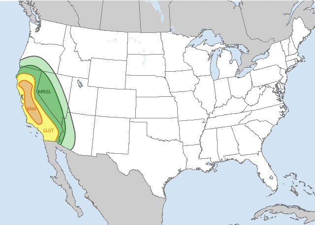
The convective outlook for the December 2nd outbreak.
After several unusually warm and humid days in the late fall in the Central Valley a system of thunderstorms from a low pressure system rolled into California starting on the late evening December 1st. Some isolated flash flooding occurred on the night of the 1st along with the first tornado watch was issued for Western Kern County from 7:30pm to 2:00am. No tornadoes or funnels were sighted on the 1st.
Very unique weather conditions is what fueled the unprecedented outbreak. A very fast rotating low pressure system moved down along the cost of the Pacific Northwest bringing a cold front down along the West Coast. The cold front soon came into contact with a dry line that had formed from a rare warm and humid weather system that traveled NW from the Southern Texas Coast effecting Arizona, Nevada, Utah, and Northern Mexico. The Jet Stream associated with the El Niño of that year was the last and final ingredient as the air masses collided over the Central Valley on December 2nd.
By 10:15am the first supercells of the day had began to develop in Northern areas of the Central Valley. Throughout the late morning and evening, 22 tornadoes occurred along the line of thunderstorms causing 29 fatalities. Severe flash flooding would also take place in the late evening hours causing two other fatalities after the tornadoes had dissipated. A total of three EF3's, five EF2's, four EF1's, and ten EF0's would touch down over the coarse of the outbreak.
| Confirmed Total |
Confirmed EF0 |
Confirmed EF1 |
Confirmed EF2 |
Confirmed EF3 |
Confirmed EF4 |
Confirmed EF5 |
| 22 | 10 | 4 | 5 | 3 | 0 | 0 |
Confirmed Tornadoes
December 2nd Event
| List of confirmed tornadoes - December 2nd, 2023 | ||||||
|---|---|---|---|---|---|---|
|
|
||||||
| California | ||||||
| EF0 | Hidden Valley Lake | Lake | 10:55am | 0.5 miles | The tornado initially formed over Hidden Valley Lake as a waterspout. It traveled NNE onto land and caused minor roof damage and uprooted several small trees. It dissipated in between Oak Grove Rd and Greenridge Rd. It was the first confirmed tornado of the outbreak. No injuries were reported. | |
| EF0 | Anderson | Shasta | 11:25am | 0.3 miles | This short-lived tornado caused minor damage to two roofs and damaged a wooden sign on a local business. No injuries were reported. | |
| EF0 | NE of Arbuckle | Colusa | 11:55am | 2.3 miles | A tornado was spotted on the ground just NE of Arbuckle by local residents. Branches were snapped off several hard and soft wood trees. Several panels of metal roofing on a farm outbuilding were torn off. The damage path was measured to be over 150 yards wide at its widest point. No injuries were reported. | |
| EF1 | Delevan | Colusa | 12:16pm | 5.1 miles | The supercell that produced this tornado also produced the Hidden Valley Lake tornado. The tornado touched down just SW of Delevan and just West of the Interstate 5. It grew to a width of 100 yards after 20 seconds of being on the ground. After crossing Interstate 5, it stuck the Delevan area with EF1 intensity with estimated winds over 100 mph (160 km/h). It significantly damaged roofing and a rice plant's metal warehouse, also causing the inward collapse of an overhead door. Several trees were uprooted or snapped and significant crop damage was done NNE of Delevan. One injury was reported from within the warehouse. | |
| EF0 | East of Capay | Yolo | 12:35pm | 0.9 miles | A very brief tornado touched town East of the Capay community. Minor roof and chimney damage was done to two homes. Branches snapped off soft wood trees. No injuries were reported. | |
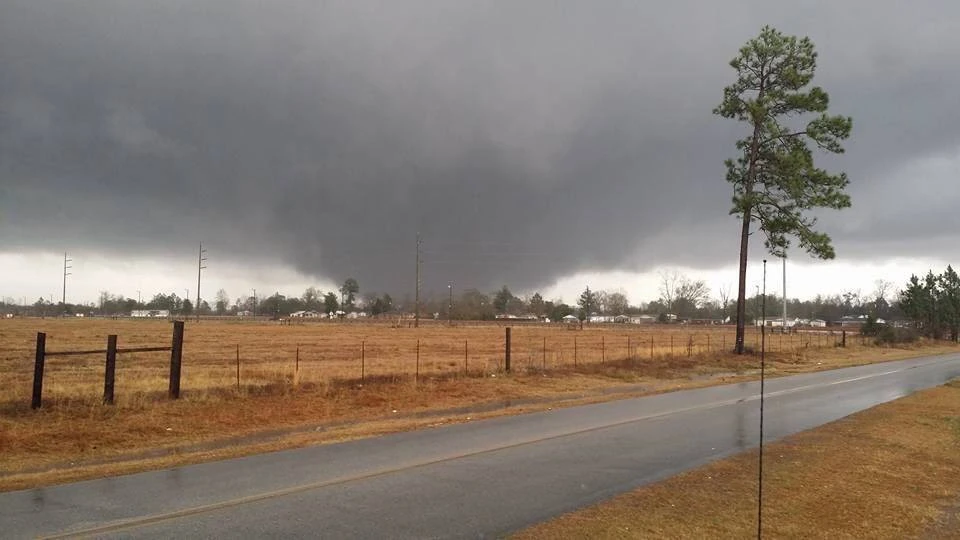
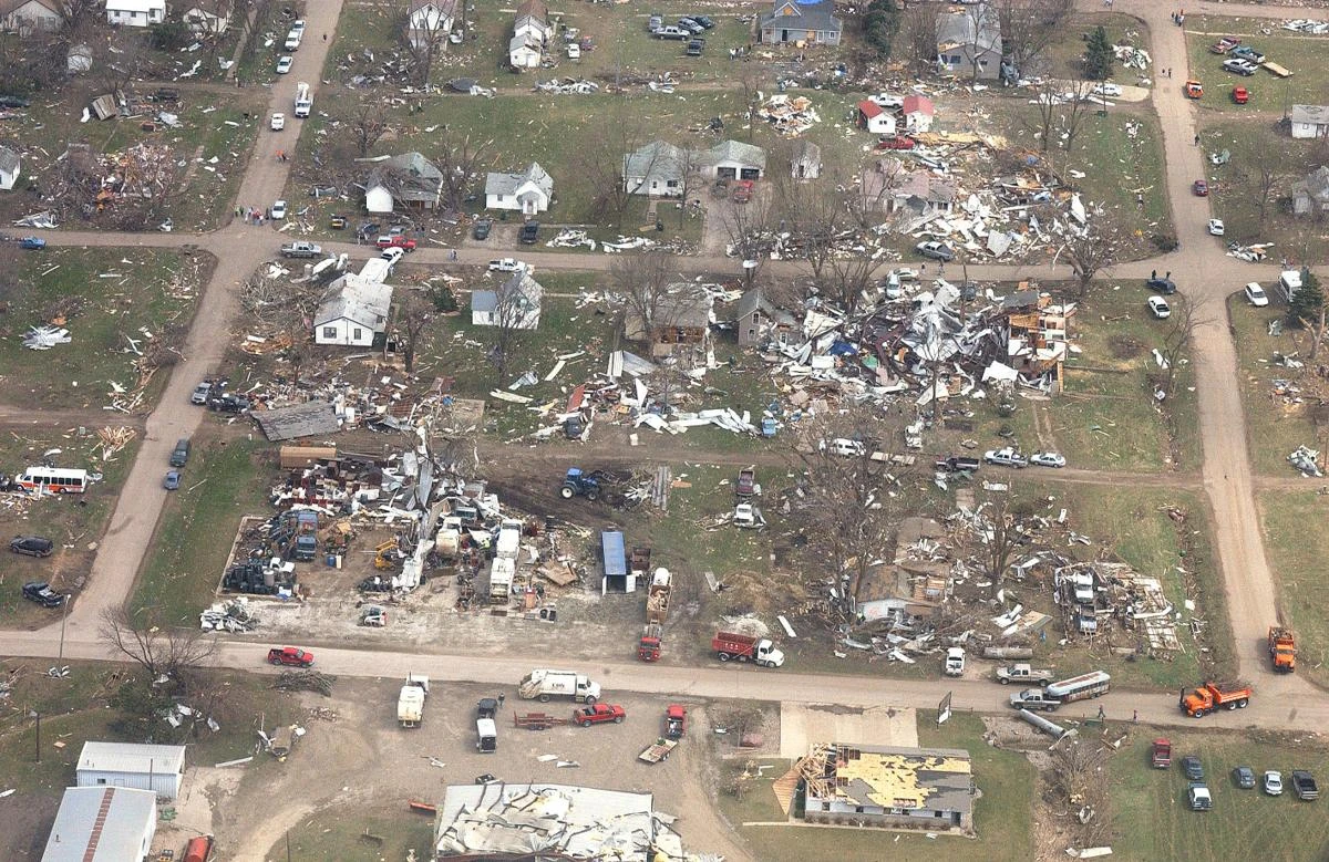
| EF3 | Hamilton City | Glenn and Butte | 12:55pm | 13.4 miles | The Hamilton City tornado spawned from the same supercell associated with the Hidden Valley Lake and Delevan tornadoes. The tornado was spotted by local farmers to the SW of Hamilton City in Glenn County. The wall cloud was described as being very low to the ground and eventually producing a slow moving multi vortex wedge tornado. The tornado hit Hamilton City about 11 minutes after touch down and was over half a mile (804 meters) wide at this point. High end EF3 damage was done to over 60% of the town with the rest of the town experiencing EF0 to EF2 damage. 16 people were killed and 115 people were injured in Hamilton City. Most of the structures in the direct path of the tornado were completely destroyed, nearly clean foundations were found in some areas. Trees had been partly debarked and many were completely uprooted. The tornado then damage several farms and rural homes with EF2 damage as it exited town, injuring 6 more people. By the time it got to the Butte County line it had weakened to EF0 strength before it dissipated just 3 miles West of NW Chico California. It was the deadliest tornado to affect the state of California and is considered one of the deadliest tornadoes to occurred in the month of December. It was also the strongest tornado of the outbreak with estimated windspeeds of 160 mph (257 km/h) as it went through Hamilton City. The tornado caused over $175 million dollars (2023 USD) in damage. See section on this tornado | |
| EF0 | Meridian | Sutter | 1:00pm | 0.3 miles | This tornado formed from the same cell as the Arbuckle tornado. Minor damage was done to the roofs of two farm outbuildings. Three trees had been uprooted. No injuries were reported. | |
| EF1 | Rio Vista | Solano | 1:43pm | 2.1 miles | Several storm spotters witnessed a low wall cloud approaching Rio Vista from the SW which produced the tornado. The tornado touched down less than half a mile to the South of the town. As it approached storm spotters noted that the base of the funnel grew to roughly 50 yards (46 meters) wide and noticed that the tornado had multiple vortices. The tornado caused high end EF1 damage as it went through the suburbs of Rio Vista. Reported damage consisted of several lifted roof decks, eight garage doors collapsed inward, and many homes suffered significant loss of roof covering material. Estimated winds were in excess of 105 mph (169 km/h). The tornado dissipated in the Northern end of Rio Vista. One person was injured according to Rio Vista police. Damages were estimated over $3.5 million (2023 USD). | |
| EF2 | Sacramento Area | Yolo and Sacramento | 2:08pm | 6.9 miles | The same supercell that produced the Rio Vista tornado later went on to produce another tornado in the Sacramento area. The tornado touched down just across the Sacramento River across from neighborhoods in Southwestern Sacramento. As it headed NNE the tornado crossed over the river into the suburbs where it immediately began to do EF1 level damage only 45 seconds after touch down. The tornado proceeded NNE crossing the Sacramento River a second time and began to affect the suburbs West of the river. EF2 damage was done to the suburbs near River City High School. The tornado crossed the river a third time directly impacting the Sacramento Marina where extensive EF2 damage was done. The tornado crossed a congested Interstate 305 where four cars were flipped resulting in the death of 1 person and 5 injuries. Once again the tornado went onto the Sacramento river where it rapidly dissipated across from the Sutter Health Baseball Park. Damage surveyors estimated windspeeds in excess of 120 mph (193 km/h) at peak strength. Closer examination determined that the max width of the tornadoes path was 250 yards (229 meters) wide. The damages of this tornado exceeded $72 million dollars (2023 USD) making it the 3rd costliest tornado of the outbreak. | |
| EF2 | Manteca | San Joaquin | 2:17pm | 5.9 miles | A tornado touched down just 110 yards (101 meters) West of the Manteca Park Golf Coarse. The tornado went through much of the central and Norther suburbs of Manteca producing widespread EF1 and EF2 damage. Several roofs were completely torn off and many backyard sheds completely destroyed. Since the tornado formed so close to Manteca less people were prepared for the tornado as it went through town. Before exiting the town the tornado injured 38 people. Many homes were heavily damaged and soft and hard wood trees were snapped in half. The tornado had an estimated windspeed of 125 mph (201 km/h) at its peak strength and was over 120 yards (110 meters) wide at the widest parts of the damage path. The tornado caused over $41 million dollars (2023 USD) in damages throughout Manteca. | |
| EF2 | Lincoln | Placer | 2:30pm | 5.3 miles | This tornado formed from the same supercell that both the Rio Vista and Sacramento tornadoes formed from. The tornado touched down very near the SW edge of Lincoln. Initially the damage as it entered town was EF0 with minor chimney and shingle damage being done to several homes. It quickly intensified to EF1 strength as it crossed California State Route 65. Several homes had suffered EF1 damage in the center of town. As the tornado entered Auburn Ravine Park it snapped many branches off hard wood trees and uprooted many softwood trees. After reaching the Auburn Creek apartment complexes it began to produce Ef2 damage. Some mobile homes had shifted off their foundations and many homes and condos had their roofs completely ripped off. Once the tornado exited town to the NE it rapidly weakened until it lifted. Reports from local first responders say that 3 people were injured in the tornado. Estimated windspeeds according to damage surveyors were between 120 and 130 mph (193-209 km/h), and the estimated max with of the damage path was 270 yards (247 meters). Damages in total were over $27 million dollars (2023 USD) to the town of Lincoln. In all the tornado family that spawned the Rio Vista, Sacramento, and Lincoln tornadoes produced over $102.5 million dollars (2023 USD) in damages, and caused 1 fatality and 9 injuries. | |
| EF2 | Clements | San Joaquin | 2:38pm | 3.4 miles | The Clements tornado was produced by the same supercell system that caused the Manteca tornado. This tornado was relatively short lived but it quickly gained strength while it was on the ground. Surveyors determined an EF2 rating with an estimated 115 mph winds (185 km/h) at peak strength. The tornado did high end EF1 damage to several farms South of Clements. Once the tornado reached town it was described as long and rope like. The tornado created a 150 yard (137 meters) wide damage path through the town. The Post Office in Clements was the most severely damaged building with its roof being blown off after being directly hit during a brief intensification of rotation. The Post Office damage was the confirmed area of EF2 damage along the damage path. The tornado soon dissipated as it exited town. The tornado cost roughly $1 million (2023 USD) in damage, including crop damage. No injuries were reported. | |
| EF0 | West of Hilmar | Merced | 2:40pm | 0.8 miles | A very thin rope funnel touched down briefly to the West of Hilmar. It did very minor tree damage and took shingles of some roofs. No injuries were reported. | |
| EF1 | Turlock | Stanislaus | 2:50pm | 4.8 miles | Near the very SW edge of Turlock a tornado touched down coming from a high elevation wall cloud. This tornado came from the same cell that caused the tornado West of Hilmar. After crossing Highway 99 the tornado passed close to Cunningham Elementary School it sustained EF0 strength for a majority of its path before it began to slowly intensify near Crane Park and Dutcher Middle School. By the time it gone over Free Methodist Church it had gained EF1 strength. The tornado did some considerable roof damage and significant tree damage as it exited town. The tornado started to weaken as it left Turlock and fully lifted a few hundred yards away from town. No injuries were reported by local authorities. Damage reports indicated that $4 million dollars (2023 USD) in damages was done. | |
| EF2 | Hickman and Waterford | Stanislaus | 3:14pm | 4.1 miles | The some storm that caused the Turlock and Hilmar tornado would later form the tornado that affected Hickman and Waterford. Storm spotters South of Hickman reported the tornado on the ground a little over a mile (1.6 km) SW of the town. The rotation began to intensify as it went through went rural areas producing EF0 and EF1 damage. Once the tornado entered Hickman it began to do high end EF1 and low end EF2 damage as it damaged rooves and some mobile homes. The tornado crossed over more farmland before entering Waterford were it produced its most significant EF2 damage. The tornado continued NE after it went through Waterford before roping out in a grape vineyard. The tornado was highly visible due to its very tall funnel giving residents time to get to safety. No injuries were reported. At its max width the damage path was measured at 250 yards (229 meters), and had estimated windspeeds of 125 mph (201 km/h). The tornado produced over $11.5 million dollars (2023 USD) in damages we. | |
| EF0 | South of San Joaquin | Fresno | 3:35pm | 1.2 miles | A very low wall cloud spotted South of San Joaquin produced a brief tornado that caused EF0 damage several soft wood trees. The tornado lifted near a farm causing minor roof damage. No injuries were reported. | |
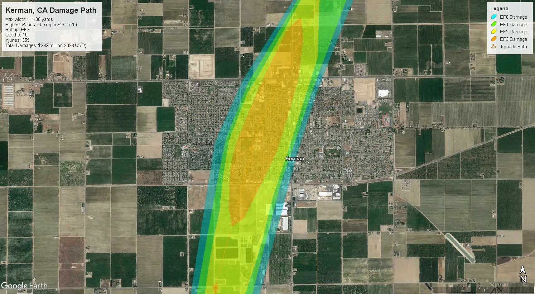
| EF3 | Kerman | Fresno | 3:48pm | 8.6 miles | As the super cell that produced the San Joaquin tornado moved NE toward Kerman a new funnel was spotted. After the funnel rapidly condensed and touched down the tornado began to intensify as it approached town. Several farms South of Kerman were in the direct path of the tornado as it began to take shape as a wedge. One farm was nearly completely leveled, a single story home was severely damaged with only a few interior walls left. Before the tornado even reached Kerman it had gained EF3 strength and its path measured over 800 yards (731 meters) wide. The tornado entered Kerman from the south as it tore a path over 1400 yard (1280 meters) wide NE through the town. The tornado uprooted or snapped every tree in both Lions and Wooten park. The tornado directly hit Kerman Middle School which suffered extensive EF3 damage as where over 250 people had taken shelter. The tornado also directly hit Nova High School where over 100 people had sheltered. The tornado went on to impact Kerman High School where over 400 people had taken shelter. Before exiting town widespread EF3 damage was done to the Kerman Plaza Shopping center. In the city of Kerman 10 people were killed and 348 were injured. The tornado destroyed several more farms and structures, injuring 7 more as continued through farmland. The tornado rapidly weakening before lifting NE of Kerman. Many of those injured and killed by the tornado were in and around Kerman Middle School, Nova High School and Kerman High School. Damage surveys concluded that the tornado had a max wind speed of 155mph (249 km/h) at peak strength. The tornado did over $232 million dollars in damages to Kerman and the surrounding areas making it the costliest tornado of the outbreak. It was also the second deadliest tornado of the outbreak. See section on this tornado | |
| EF1 | Biola | Fresno and Madera | 4:02pm | 2.3 miles | This tornado formed from the remnants of the cell that produced both the Kerman and San Joaquin tornadoes. As the wall cloud approached Biola a funnel cloud was spotted. The initial touch down occurred a few hundred yards South of the Biola-Pershing Elementary School. The tornado produced EF0 damage to several roofs and snapped branches off trees at the school. The rotation briefly strengthened near the NE edge of town where some significant damage was done to roofing materials on two homes. The tornado continued through farmland NE of Biola before dissipating in rural Madera County. The damage surveyors found EF1 damage to a small section of homes and estimated windspeeds to be 90 to 100 mph (145-161 km/h). No injuries were reported. | |
| EF0 | Kingsburg | Fresno | 4:10pm | 4.5 miles | A long rope-like funnel touched down SW of Kingsburg causing minor damage to several farm outbuildings. The tornado crossed over California Highway 99 between the town of Kingsburg and the Sun Maid factory. It lifted over a field just North of town. No injuries were reported. | |
| EF0 | Buttonwillow | Kern | 4:25pm | 0.6 miles | This tornado formed on the NE edge of the Buttonwillow city limits. It caused minor EF0 damage to the Buttonwillow Rest Area uprooting several small trees and ripped the shingles off some roofs. No injuries were reported. | |
| EF0 | Reedley | Fresno | 4:30pm | 0.8 miles | A short-lived tornado formed near Northern Reedley from the same storm that produced the Kingsburg tornado. The tornado broke limbs off of small trees and did minor rood damage. After crossing a road, the tornado lifted near the Kings River. No injuries were reported. | |
| EF3 | Wasco and Delano | Kern and Tulare | 4:42pm | 17.2 miles | The Wasco-Delano tornado was the last tornado of the outbreak. The tornado formed from the same storm as the Buttonwillow tornado and touched down near the SW edge of Wasco. The tornado was very hard to see since the sun had set shortly after touch down making the tornado only visible by lightning and power flashes in its later stages. As it went through Wasco it produced mostly EF1 level damage, but the tornado was also quickly getting stronger as it went through town. The tornado did EF2 damage to a trucking company warehouse where it threw several semi-truck trailers, one being lifted an estimated 80 feet into the air. Metal warehouses also experienced heavy damage as some of their walls had collapsed and the metal roofing was torn off. Local authorities reported 4 injuries in Wasco. The tornado moved NE from Wasco through farmland. It did extensive damage to crops as well as high end EF2 damage to several farms causing 3 more injuries. Only a few hundred yards from Delano, a vehicle was rolled several times by the tornado at Schuster Rd South of Delano. The driver of the vehicle was killed. The tornado began to turn more East as it headed into Delano. As the tornado passed through the SW suburbs of Delano it caused EF3 level damage to several homes. Then the tornado crossed over California Highway 99 where it began to weaken creating some EF2 but mostly EF1 damage. The tornado rapidly weakened as it exited NE Delano. The tornado dissipated at 5:10pm shortly after it crossed County Line Rd Ave 0 into Tulare county. In Delano 1 person was killed in the Southwest suburbs and 28 were injured across the city. In total there were 2 fatalities and 35 injuries were caused by this tornado. A total of $68.5 million dollars (2023 USD) in damage was done. The max width of the tornado was determined to be 400 yards (366 meters) with max windspeeds over 140mph (225 km/h). This tornado was the longest tracking tornado of the outbreak with a 17.2 mi (27.7 km) long path.See section on this tornado | |
Notable Tornadoes
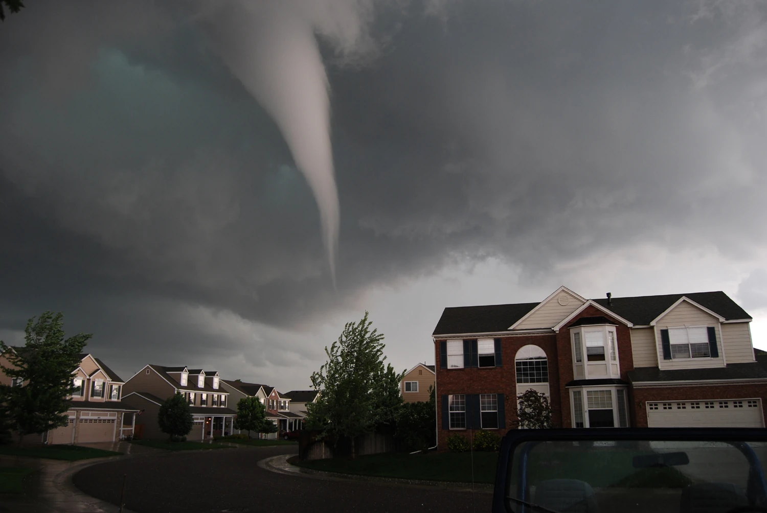
Hamilton City, CA Tornado
The Hamilton City tornado as it approached town.
The Hamilton City EF3 tornado was the first tornado to do wide spread damage and cause fatalities during the outbreak. Prior to news of the tornado, the outbreak was being largely ignored or overlooked by most California residents. This tornado marked a dramatic shift in the outbreak when significantly more powerful tornadoes began to develop. Over the next 2 and half hours after the initial touch down of the Hamilton City tornado a majority of the significant tornadoes that occurred in the outbreak would take place. The Hamilton City tornado was the first recorded case of a tornado causing fatalities in California state history. After reports of the tornado began to circulate after Hamilton City was struck state residents began to take the ongoing outbreak more seriously. While Hamilton City residents had been warned about the tornado many claimed local news outlets had not covered the warning with enough urgency.
The tornado first touched down at around 12:55pm, but the tornado was not first spotted until around 12:58pm by local field workers who described it as a low rotating bulge spinning up dirt and debris beneath it. This was the third and final tornado to be produced by a single supercell that caused both the Hidden Valley Lake and Delevan tornadoes.
By 1:00pm the tornado had already traveled over 3 miles since touch down and had begun to rapidly strengthen. The tornado had produced high end EF2 damage to several buildings. A metal building system had suffered the loss of over 80% of its metal panels and the roof purlins began to buckle under the windspeeds. Some outbuildings in the path were entirely leveled with debris spread several hundred yards away from where the buildings had stood. One house closest to the core of the path had a third of its exterior walls collapse as well as having its roof completely removed suggesting the tornado was already very close to being able to cause EF3 level damage. At 1:05pm the tornado had reached near peak intensity a little less than a mile from Hamilton City and was now in clear view of its residents as many hastily began to run for cover in the last moments before the tornado struck town. Four more homes were hit just outside of town. Damage to all four houses was high end EF3 damage as most exterior walls had collapsed leaving only small internal walls standing and roofs had been completely torn off. Several residents described seeing a tractor being "flung in the air like a toy" right before the tornado entered Hamilton City.

Damage in Hamilton City, CA.
Once the tornado entered the city at 1:07pm from the SW edge, it had immediately begun doing EF3 damage to homes and the structures at Hamilton Elementary School. Some of the school structures had their roofs partially or completely torn off. The post office was nearly leveled as all of its exterior walls where removed and a half of the interior walls had collapsed. An old abandoned warehouse formerly used as a sporting complex near the center of town was hit directly by the core of the tornado. The building had completely collapsed as the tornado ground through the area. The tornado continued over the train tracks in the center of Hamilton City and proceeded to do extreme damage to the Eastern half of town where it is believed the tornado reached peak intensity. Every 'lower bound' constructed home in the tornado's direct path at this point was completely leveled with no walls left standing. Winds here were estimated in excess of 160 mph (257 km/h) which nearly gaining the tornado an EF4 rating. The rating was controversial considering the Dec 2nd event was the first time damage surveyors in the state had ever experienced tornado damage at this scale, many believed because of the lack of experience the damage surveyors rated the tornado lower on the EF scale. Similarly to the later Kerman tornado, the Hamilton City tornado did not directly impact any homes or buildings that were structurally sound enough to determine if the tornado was worthy of an EF4 rating. Most of the homes in both towns were not built to withstand significant let alone violent tornado damage.
The tornado continued NE out of Hamilton City into more farmland still being described as a wedge tornado for a few more miles. By the time the tornado had reached a large industrial farm its funnel had began to rope out. At the industrial farm the tornado caused brief EF2 level damage to a metal building system and mostly EF1 damage to the other buildings on the property. The tornado continued NE for another mile before it lifted at around 1:15pm.
Hamilton City was extensively damaged by the tornado with over %75 of buildings in town being deemed uninhabitable. EF3 damage covered over 60% of the town. In total over $132 million dollars (2023 USD) in damages were done by the tornado. Overall the tornado killed 16 people and injured 121 people, only 6 were injured outside of Hamilton City. This was both deadliest tornado of the outbreak and the deadliest tornado to occur in California state history. The state of California declared Hamilton City a disaster zone 2 hours after the tornado had passed. Many blamed the local new networks for not having put enough emphasis on the tornado warning that was issued for Hamilton City. Many believe this caused residents of Hamilton City to not get to shelter in time. News outlets had not been using doppler velocity data to check on the intensity of the rotation since it was never needed on the news in the state prior to the outbreak. Only after the outlets had realized how bad the Hamilton City tornado was did they start checking velocity data on the air. Several local news outlets were sued in the aftermath of the outbreak, and the lawsuits are still ongoing with no outcomes yet.
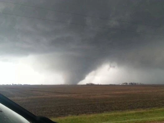
Kerman, CA Tornado

View from NE Kerman as the tornado went through town.
The Kerman tornado would be the second deadliest, the largest in terms of width, and the costliest tornado of the December 2nd outbreak. Many residents in Kerman began to get to safety after hearing that the storm that produced the San Joaquin tornado was headed towards town. Over 250 residents had sought shelter in Kerman Middle School, nearly 100 in Nova High School and another 400 had went to Kerman High School for shelter prior to the tornado. Most residents did not have a basement or underground shelter forcing many to take cover in the centermost areas of their homes and encouraging others to evacuate town before the storm's arrival. Residents across California were tuned in to local news outlets by this point. Most of the local news were focused on the Kerman area as the radar signature began to show a distinct hook echo as well as a strong velocity signature. A few news crews were situated around the Kerman area at this time and live footage was being streamed on the air of the approaching storm. At this time many outlets across the US began to cover the events unfolding in California as well.
A news crew closest to the storm was able to capture footage of the funnel's formation. The wall cloud of the storm was very low to the ground and the funnel appeared as a wide bowl shape under the cloud. The tornado touched down at 3:48pm as the storm continued to move closer to Kerman. A minute after the confirmed touch down the NWS declared it's first ever tornado emergency for the state of California. The emergency polygon stretched from SW of Kerman to Biola, CA. Only a few hundred yards after it touched down the tornado did its first recorded structural damage to a small farm. A few flimsy outbuildings were heavily damaged by the tornado and a single story home had many of its windows shattered as well as having a door blown off its hinges.
By 3:54pm the tornado had already trailed over 2 and one half miles (4 km) and had already began to take shape as a wedge tornado. The tornado was very quickly strengthening as it got closer to Kerman. The next structure in the path of the tornado was much more significantly damaged than the first. By this point the damage path had already grown to over 700 yards (640 meters) wide. The single story home on the property suffered a near direct hit by the core of the tornado as it was unroofed and some exterior walls had collapsed. There were many vehicles and palates all around the property and the nearest news crews had gotten footage of several vehicles being flung dozens of feet into the air. It was later determined that strong EF2 damage was done to the property. After another mile of travel the tornado hit another farm where it did its first EF3 level damage by nearly collapsing every wall of a house and debarking some trees surrounding the home. Strong EF2 damage was done to the Kerman Animal Control Center as well as two nearby businesses and a church. The tornado produced one more area of EF3 level damage at 3:58pm before entering town as it nearly leveled a farm only a few hundred yards from south suburbs of Kerman. By this point the tornado was nearly at its max width and already producing light damage in town as it destroyed the farm.

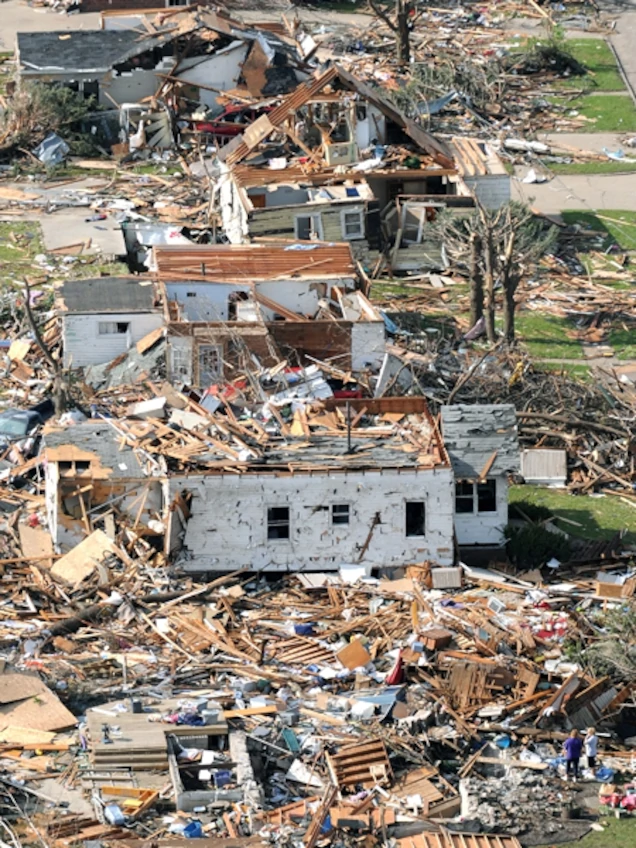
Damage map from the Kerman, CA tornado.
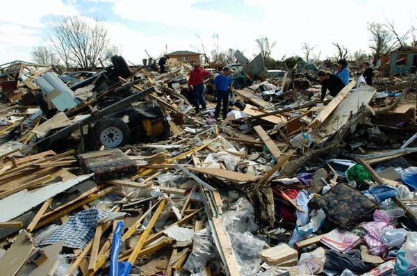
The tornado entered Kerman from the South and began to carve its path NE through the center of Kerman. The tornado began to produce extensive EF3 damage causing two story apartments to have their top floors nearly collapsed, leaving few or no walls standing in many homes. The tornado then directly impacted the Kerman Middle School where many had taken shelter. The tornado unroofed all of the school's buildings and many of the walls had collapsed as well leading to the deaths of 2 people inside and 133 injuries. It took 18 hours to recover everyone that was trapped in the school's rubble. The most severely affected school in town was Nova High School as it was much smaller and built to withstand the severe winds it had experienced that day. The tornado collapsed most of the exterior walls of the building on campus and every building had its roof entirely torn off, 5 people were killed and 91 others where injured on the school grounds. The homes in between both high schools suffered the most extreme residency damage where many had all of their walls collapsed some with nearly cleaned slabs as many of the homes were older and not built to withstand strong winds. Kerman High School suffered EF3 level damage to some of its buildings as the core of the tornado's path was more to the East of the campus. All of the windows on campus were broken and significant roof damage was done to most of the school as well. Of the 400 that were sheltered in Kerman High School 84 were injured and miraculously no one was killed. The tornado proceeded through more homes and before exiting town impacted the central business and shopping area of Kerman. The tornado caused one more area of significant damage to town as it blew much of the roof off and caused many walls to collapse inward at the Garcia's Supermarket as well as heavily damaging the Kerman School District building and causing high end EF3 damage to many of the shopping center buildings.

High-end EF3 damage from the Kerman, CA tornado.
The tornado exited Kerman at 4:01pm and continued NE in the direction of Biola, CA. A news crew on the NW edge of town had filmed the entire event while the footage was being broadcast live on television. The tornado continued into the rural areas NE of Kerman causing significant damage to several other farms before it began to dissipate. The tornado roped out at 4:06 pm. The same cell would later drop one more tornado over Biola, CA where it did some EF1 level damage before the cell completely dissipated.
Between all the schools that were hit by the tornado a total of 7 people were killed and 305 were injured. Across the rest of Kerman 3 more were killed and 43 others were injured. In the rural areas surrounding Kerman an additional 7 people were injured. In total the tornado killed 10 people and injured 355 others. A total in $232 million dollars (2023 USD) in damage was done by the tornado along its 8.6 mile long path. At max width the damage path was measured at just over 1400 yards (1280 meters) while it was in Kerman. The max windspeed was determined to be in excess of 155 mph (249 km/h). This rating caused some controversy since the California NWS teams did not have extensive experience in measuring tornado damage at this scale and many believed the rating may have been as high as EF4. While others point to the fact the much of Kerman was not built to withstand high windspeeds making damage assessment beyond high-end EF3 near impossible.
Kerman was declared a disaster zone an hour after the tornado had subsided by the state of California. The Kerman and Hamilton City tornadoes where considered the most uniquely violent tornadoes of the outbreak. These two tornadoes became very intriguing case studies for meteorologists around the country for their unique intensity in an area where it was so unlikely to happen. In the years to come some meteorologist would find that this was just the beginning of a trend of more "out of place" severe tornado outbreaks to take place along the Western portion of the US.
Wasco-Delano, CA Tornado

Photo taken of the Wasco-Delano tornado as it went through Wasco, CA
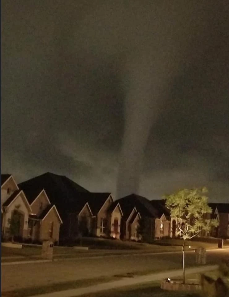
The final tornado of the outbreak was the Wasco-Delano tornado. The tornado was the longest-tracking tornado of the outbreak, with a path of over 17.2 miles (27.7 km) long. It was also the third strongest tornado being the weakest of the EF3 tornadoes that occurred on December 2nd. It was also the last tornado to cause fatalities during the outbreak. The tornado was barely visible as it took place after sunset. By this point in the day news of the outbreak had reach most people in the US and many in various other countries. The largely affected areas across California had already began rescue and clean up operations in the aftermath of prior tornadoes. Circulation of the death toll at the time was reported as being "over 2 dozen dead" as reported fatalities started to come out. Many residents in both towns were well aware of the severe weather on the way and were on high alert because of how dangerous the event had already proved to be.
The storm cell that caused the Buttonwillow tornado produced the Wasco-Delano tornado. It touched down at 4:42pm just outside the SW edge of Wasco and within seconds of being on the ground it entered the city. The tornado came into town through the Teresa Burke Elementary School grounds. Minor EF0 damage was to some roofing material damage on the school buildings and some of the trees in the school yard had branches snapped off. The tornado continued NE into the suburbs of Wasco creating EF1 level damage. Some lower bound homes that were hit by the tornado ended up loosing most of their roofing with a wall collapsing in one. Several trees had been uprooted or lost multiple large branches. The tornado slowly strengthened as it went through the business sector of Wasco were it did its first EF2 level damage. Several small retail buildings had their roofs collapse under the intense winds and blowing protective canopies away on many buildings. The tornado then reached a semi truck garage were it was well into the EF2 rating. Several demi truck trailers were damaged while one was thrown over 80 feet (24.4 meters) into the air. The metal warehouse was heavily damage as most of its roof had been taken off and several walls had collapse. The tornado left significant tornado damage and 4 injured in Wasco as it went NE through farmland towards Delano. At 4:47pm the tornado exited NE Wasco traveling roughly 2 and one half miles (4 km) across the town.
A few moments after exiting Wasco a large farming structure was hit causing the building to collapse which was determined to be EF2 strength damage. The tornado did not hit any structures for over 3 one half miles (5.6 km). Several storm chasers were nearby filming the tornado in the last minutes of twilight as it went through several fields. In the videos taken by chasers the tornado appeared to be strengthening as it passed through farm land doing significant crop damage. Soon after at around 4:51pm tornado then hit a small farm, completely demolishing a big outbuilding. At 4:54pm after grinding through farmland another 2 miles (3.2 km) a rural home was impacted by the tornado, causing considerable EF2 damage to the roof of a house. Less than two mile (3.2 km) from the city of Delano, the tornado past over Schuster Road flipping and rolling the car of a field worker driving to his apartment in Delano. The unnamed field worker was killed in the car as it rolled several hundred feet off the road. At 4:58pm the tornado impacted a metal building after traveling another two and one half miles (4 km) over fields and roads. The building completely collapsed by the strong tornado, this would later be rated as the first EF3 damage from the tornado.

Image of EF3 damage in Delano
Right before the tornado first started doing damage to the SW suburbs of Delano it had slowed rapidly slowed and curved off to the East. As described by local witnesses the funnel of the tornado become less wide, but its rotation appeared to tighten also. At 5:01pm the tornado began damaging the first structures in its path as it tore through town. All homes in the direct path experienced heavy or complete roof loss while collapsing exterior walls on some homes. At this point the tornado was rated EF3 with winds of 140 mph (225 km/h). The tornado moved quite slowly over the SW neighborhoods of Delano traveling less than 20 mph (32 km/h) at times. The tornado continued to do EF3 level damage until it began doing EF2 level damage before crossing California Highway 99. At 5:04pm the tornado crossed the highway were it rolled two cars injuring several. After crossing the highway the tornado began doing some EF2 and mostly EF1 damage to several retail buildings. Most of the buildings hit by the tornado suffered significant roof damage and shattering of many or all windows. The tornado did more EF2 and EF1 damage to the business district, and it was clear the tornado was weakening. The tornado did its last bit of EF2 damage to a few homes in the suburbs to the SW edge of Delano High School. After impacting