NOTE: This article is once again in active construction.
The Christmas Week Outbreak of 2022 was a devastating event for the midwestern United States. It came with a surprise on December 24th, 2022, and 12 tornadoes wrecked Nebraska. On Christmas Day 2022, 51 tornadoes struck 9 states, killing a total of 1,024. On the following days, 412 more tornadoes spread throughout the US, killing 3,956 and injuring over 6,000.
It was ranked as the #1 worst tornado outbreak of 2022.
 | |
| Type: | Unknown |
| Active: | December 24th-30th, 2022 |
| Duration of tornado outbreak1: | 7 days, 8 hours and 12 minutes |
| Maximum rated tornado2: | EF5 tornado |
| Highest winds | 321 mph |
| Tornadoes confirmed: | 475 |
| Damage: | $2 trillion (2022 USD) |
| Injuries: | > 15,000 |
| Fatalities: | > 9,000 |
| Areas affected: | Contiguous United States |
|
1Time from first tornado to last tornado | |
Day One (Dec 24th, 2022)[]
December 24th was a surprise day for tornadoes, as there were none predicted at 10:00 AM CST. But the clouds covered the sun at around noon. It began to rain and citizens were confused, but not prepared for what would happen today. But most people didn't care, as it was Christmas Eve, and tornadoes were the last thing on people's minds today.
Notable Tornadoes of 12/24/2022
EF3 Tornado In Arbor, NE[]
At around 1:30 PM, a supercell formed 2 miles north of Arbor, NE. At around 1:35 PM, a funnel could be seen heading South on US-77, approaching Arbor. The rather fast-growing tornado touched town at 1:37 PM north of Arbor. It was heading fast toward the small town and at around 1:40 PM, Arbor was struck by the now EF2 tornado. Moderate to damaging destruction was seen in the Northern parts of the town. But as it tore through the Southern part, it gained an EF3 status. It caused moderate to severe damage for the rest of the town and injuring 12 people.
")
EF3 Tornado in Waverly, NE[]
After the Arbor tornado, people were beginning to panic a little. Worrying about what could happen next. The same supercell that produced the Arbor tornado dropped yet another at 2:02 PM CST, west of Waverly. As it came through, it gained immense power, increasing in size and scale, and at around 2:15, it grew to an EF3. The tornado moved along Cornhusker Hwy and did considerable damage to central Waverly. It killed only one person, a man hiding in a grass field. The tornado picked him up and threw him across the field, killing him.
")
EF4 Tornado in Greenwood, NE[]
As people were getting ready to celebrate Christmas, a surprise supercell appeared on radar at around 9:25 PM CST. This would be the deadliest of the Christmas Eve tornadoes. Citizens prepared for the last tornado to hit Nebraska. The supercell produced a tornado 2 miles East of 60 US-6. Storm chasers tracked the tornado on its journey to the village of Greenwood. It struck the Northeast part of Greenwood with winds of 103 mph. It ripped apart some houses and toppled trees. As it moved Southwest, it reached winds of 168 mph, tearing the village apart, and causing extreme damage to houses and even threw a train in the air. Over 60% of Greenwood was destroyed by the tornado and 5 people were killed. 25 were injured. This was the last tornado of December 24th and the deadliest.
")
Day Two (Dec 25th, 2022)[]
Christmas day was here, and people took their minds off the tornadoes of yesterday, as it was time to celebrate with friends and family. But 51 tornadoes struck 9 states that day, delaying Christmas and causing unbelievable damage to the midwestern US in general. Some of the damage can even be seen from space. 1,024 people were killed and injured many more.
Notable Tornadoes of 12/25/2022
EF5 Tornado in Omaha, NE[]
At 8 AM CST, many families woke up for Christmas to open presents in Omaha. But little did they know that at the same time, a deadly supercell was forming in a thunderstorm 4 miles South of Omaha. Hail was seen it huge amounts in the village of Murray, South of Omaha. The storm only got stronger as it headed North toward Omaha. The sky darkened, and families were annoyed but understood that this might be another possible tornado. It heavily rained in Omaha and hail was dropping from the skies. Roads began to flood and close. At 9:30 AM CST, a funnel was spotted by storm chasers in Boys Town. The funnel touched down at 9:31. It quickly grew in size and intensity, instantly becoming an EF1 with winds of 100 mph. As it grew, buildings and houses were torn apart and destroyed. It slowly moved west toward Downtown Omaha and left a trail of carnage behind it. At 9:50, it became an EF5, with winds of 205 mph. Obliterating central Omaha and other districts of Omaha. It headed for downtown. At Eppely Airfield, planes were smashed together and the terminals were demolished. A plane was just taking off carrying mail. Only 2 people were killed, the pilot and the co-pilot. Christmas turned into a nightmare. The tornado dissipated at 10:03 AM CST. A path of destruction was everywhere and Omaha would never be the same for months. A total of 55 people were killed, and 428 people were injured.
")
")
")
Des Moines, IA EF4 Tornado[]
Around the same time as the Omaha tornado, a large group of thunderstorms formed a supercell near West Des Moines. It would devastate Polk county and interrupt the Christmas joy. Thunder was everywhere and lightning lit up the skies. The pressure was very low, the perfect conditions for a tornado to hit. A tornado watch was issued for Polk county at 9:42 AM CST. Storm chasers gathered on I-35 to witness the tornado. At 9:48 AM, a funnel was spotted in West Des Moines, heading Northeast. The tornado touched down with initial winds of 66 mph. It remained skinny but winds increased pretty fast. It quickly tore down houses and stores and moved Northeast to Des Moines. It hit Des Moines International Airport with winds of 143 mph. Planes were tossed around and severe damage was done to the building. Significant hail damage was present as well. As it crept toward Des Moines, it reached winds of EF4 ranking. Trees were uprooted and debarked, houses were demolished, and cars were thrown into the air. In the end, Des Moines has torn apart with 39% of the city destroyed.
")
")
")
Denver, CO EF4 Tornado[]
At 12:05 PM MST, a severe thunderstorm generated a supercell capable of producing a tornado. As people were celebrating Christmas, they did not pay attention. A severe thunderstorm warning was issued for Jefferson and Arapahoe counties. Golfball sized hail fell from the sky and it rained heavily. It was unusual for this kind of weather to be in December. At 12:17 MST, a funnel was seen West of CO-470, heading northeast toward Lakewood and Denver. It touched down in East Lakewood. As it went Northeast, it reached speeds of 110 MPH, damaging apartments and uprooting small trees. A tornado warning was issued for Jefferson county at 12:21 PM MST. The wide tornado-ravaged Lakewood and entered Denver as an EF3. It hit the districts of Barnum and Valverde with EF3 damage, with well-constructed houses being torn apart, and large buildings being severely damaged. The tornado moved Northeast at 49 mph and hit the districts of Sun Valley and Lincoln Park with speeds of 169 mph. The houses there were completely leveled and parts were scattered everywhere. The streets there were unable to see under all the rubble. The tornado was now moving to downtown Denver at a speed of 45 mph, with 173 mph winds. This area was hit the hardest. Brick houses were almost completely gone and cars and trucks were in the air. Hail was present as well creating deadly ice bullets. The tornado moved east to Aurora and dissipated there. Overall, 40% of Denver was filled with EF3-4 damage. 124 people were killed and many more injured. Thousands were left homeless and the whole city without power.
")
")
")
Minnesota-Wisconsin EF5 Tornado[]
At 12:34 PM CST, a supercell was spotted moving East at 35 mph towards Minneapolis, MN. A severe thunderstorm warning was issued for Hennepin and Ramsey counties. Rain flooded low-lying parts of Minneapolis and wind gusts caused minor damage to roofs. A funnel dropped down from the supercell at 12:40 PM CST. A tornado warning was issued for Hennepin county at 12:41. The tornado touched down in Hutchinson, causing EF0-EF1 damage there. Windows were broken and roofs were damaged. Small trees were broken and mobile homes were damaged. The tornado intensified as it entered Minneapolis in the eastern part. EF2 damage was reported for the eastern part with roofs torn off, cars lifted, and trees uprooted. It quickly grew deadly as it shredded through Minneapolis, reaching speeds of 145 mph. It did high-end EF3 damage to Southwest Minneapolis, with collapsed buildings and damaged high-rises. As it entered central Minneapolis, it caused EF4-EF5 damage, leveled buildings, foundations visible. Some high-rises fell. The tornado went on to cause EF3 damage in St. Paul but gained more strength as it entered Wisconsin. The now EF4 tornado traveled at a speed of 50 mph to Eau Claire in Wisconsin, causing severe damage and destruction. It dissipated just outside of Eau Claire, having killed 153 people.
")
")
")
EF3 Milwaukee, WI Tornado[]
At 2:57 PM CST, a supercell was formed 5 miles east of Mequon. A severe thunderstorm warning was issued for residents of Mequon while they were celebrating Christmas. The supercell grew bigger and had winds of 35 mph making it unsafe to drive and the rain making it hard to see. At 3:01 PM CST, a funnel was seen on the ground heading east on WI-164. It quickly became a rain-wrapped tornado, one of the deadliest types, making it hard to see. It produced EF0-EF1 damage in Sussex but quickly intensified into an EF2. By the time in moved to Mequon, it produced high-end EF2 damage with roofs torn off and cars being lifted. It began to move north to central Milwaukee at around 3:15 PM CST. It hit Timmerman Airport with EF3 damage, lifting some planes and severely damaging the interior of the airport. It hit downtown Milwaukee with EF3 damage and winds of 160 mph. Severe damage was seen throughout Milwaukee and 43 people were killed. This was one of the largest tornadoes to hit on 12/25 with peak size being 2.1 miles wide.
")
")
")
")
St. Louis EF5 Tornado[]
At 6:37 PM CST, a supercell was spotted 7 miles northwest of St. Louis. A severe thunderstorm warning was issued for St. Louis at 6:40 PM. Rain and wind hit St. Louis hard, with winds of 40 mph. Trash was scattered on the roads and highways. At 6:45 PM CST, a funnel was spotted on the ground moving at a speed of ~35 mph heading east towards St. Louis. It hit Chesterfield causing EF2 damage to much of the city and other structures. It headed east at 60 mph reaching EF3 status and causing EF3 damage to structures and trees in Richmond Heights, Kirkwood, and Clayton. It started to hit St. Louis with EF4 damage but as the tornado got more intense, it reached EF5 status. It ravaged St. Louis, destroying 1,500 buildings. It managed to destroy the St. Louis Lambert International Airport with winds of 225 mph. Parts of buildings were everywhere and some streets were flooded. A total of 677 people were killed and this event is classified as the "worst thing to ever happen to St. Louis".
")
")
")
Day Three (December 26th, 2022)[]
December 24th was considered the deadliest day of the week. There was a rare 60% hatched risk of tornadoes for parts of the midwest, and 45% and 30% were also in place. Reports of golfball size hail were in 12 states. The largest of them being 6 inches in Illinois and Oklahoma. A huge storm system spawned 70 of the total 104 tornadoes that day. A separate storm spawned the rest of the tornadoes in the northeastern US. Tornadoes touched down in 20 states that day. >4,000 people were killed that day and >5,000 injured.
")
Notable tornadoes of 12/26/2022
EF4 Tulsa, OK Tornado[]
At 5:50 AM CST, a powerful supercell was spotted a mile North of Owasso going 35 mph. Winds in Owasso were up to 45 mph causing minor damage throughout the town. Power was shut down and it was hard to see anything. At 6:02 AM CST, a funnel was seen near OK-20 and touched down south of it. It hit Owasso with EF0 to EF2 damage as the tornado moved slowly through Owasso. It remained skinny as it gained EF3 status. It moved south towards Tulsa, hitting the northern parts with winds of up to 160 mph and causing high-end EF3 damage to many buildings there. As it moved south through downtown Tulsa, it caused EF4 damage to hundreds of buildings. A mix of rain, debris, and wind made it extremely hard to see, making it one of the more fatal tornadoes of that Monday. As the tornado moved out of Tulsa, it hit Liberty and Winchester, causing EF4 to EF3 damage. The tornado dissipated outside of Winchester, ending the path of destruction it caused. Due to it being rain-wrapped, it caused 136 people to be killed. It dissipated at around 6:35 AM CST.
")
.png "Chapman 2016 radar (7-07 pm).png (18 KB)")
")
Dallas - Ft. Worth EF5 Tornado[]
At 7:30 AM CST, a tornado watch was issued for the DFW area as storm chasers spot a supercell capable of producing a tornado south of Cleburne. Golfball sized hail was reported in Tarrant and Dallas counties and heavy rain was present as well. Low-lying areas were flooded and some streets were in 2 ft deep water. 40 mph winds were present in Ft. Worth and caused minor damage to it and other suburbs. Sirens were heard at 7:35 AM as a funnel was spotted a mile south of Cleburne. It touched down on US-67 heading northeast towards the DFW area. It caused EF1-EF2 damage in Cleburne and surrounding suburbs. As it moved northeast, it hit southern Fort Worth with speeds of 145 mph, causing high-end EF3 damage to that part of the city, destroying well-built houses and tossing cars into the air. As it slowly moved north, it reached EF4 status, causing EF4 damage throughout central Fort Worth. It moved east, badly damaging Arlington, Euless, and Grapevine with EF4 damage. As it entered Dallas County, it reached EF5 status and hit eastern Dallas with speeds of 215 mph. It moved east through Dallas, causing complete obliteration in downtown, toppling skyscrapers, and making any part of the city unrecognizable. As it moved northeast out of Dallas, it began to dissipate as it hit Garland and Rowlett, causing EF3 damage there. It fully dissipated at 8:05 AM CST. It was a really big tornado, with a width of 2.2 miles as its peak. It caused a whopping 725 people to die and injuring over 1,000.
")
")
")
")
Richmond, VA EF4 Tornado[]
At 7:54 AM EST, a severe thunderstorm warning was issued for residents of Richmond, VA. Storm chasers spotted a supercell south of Petersburg heading north at 43 mph. Heavy rain was present and winds of up to 40 mph were reported in Petersburg. As the supercell moved north, a funnel was seen in Petersburg, touching down at 8:00 AM EST. By now, wind gusts were at 55 mph and the tornado caused EF1 damage to Petersburg. It quickly intensified as it moved north towards Richmond and surrounding suburbs. Baseball sized hail was seen in Richmond as the tornado got closer. Southern parts of Richmond saw speeds of 125 mph and EF2 damage to buildings and trees. As it tore through, it reached EF3 status, with winds of 140 mph in central Richmond. Downtown was hit the worst, with EF4 damage done to many buildings, including high-rises. The tornado weakened outside of Richmond, causing EF3-EF2 damage in Glen Allen and Ashland. The tornado dissipated 1 mile north of Ashland at 8:32 AM EST. 52 people were killed and 450 were injured. Richmond was without power for 2 weeks after the tornado hit.
")
")
.png "Linwood, KS velocity (no labels).png (30 KB)")
Buffalo, NY EF2[]
At 8:06 AM EST, a supercell was spotted in Akron, NY heading west at 30 mph. This supercell quickly dropped a funnel that touched down in Akron, initially causing EF0 damage to the small town. As it moved west, it reached EF1 status and headed for Buffalo. Heavy rain was present as the tornado moved closer to Buffalo. When it hit the eastern side of Buffalo, it had speeds of 115 mph, causing EF2 damage throughout eastern Buffalo. Roofs were torn off, trees were uprooted, and cars lifted into the air. It moved across the Canadian border but quickly dissipated as it hit Niagra Falls with EF0-EF1 damage. No one was killed, but 45 people were injured.
")
")
")
Kansas City EF5[]
At 9:20 AM CST, an intense supercell was spotted in Olathe, KS. It quickly spawned a funnel that touched down in Olathe. It did EF1 damage to most of Olathe and caused a power outage for Olathe and surrounding towns. It moved northeast toward Kansas City, causing EF2-EF3 damage in the northeast part of the city. It intensified to an EF4 as it hit central Kansas City, causing EF4 damage and destroying a big chunk of the city. Cars were thrown for miles, big trucks were lifted in the air, and well-built apartments were almost completely demolished. Kansas City was left as a trash heap and the tornado only got stronger. Then, it crossed into Missouri, where it hit the other Kansas City with EF5 damage, turning the city into a deserted wasteland with parts of buildings everywhere and trees gone. Foundations were visible and high-rises were severely damaged. It caused EF4 damage to surrounding suburbs and dissipated at 10:01 AM CST near Lexington. 502 people were killed and 773 people were injured.
")
")
")
Grand Island, NE EF3[]
At 11:23 AM CST, a supercell capable of producing a tornado was spotted in Alda, NE. A severe thunderstorm warning was issued for Alda and the city northeast of Alda, Grand Island. Not much later, a funnel was seen near Alda at 11:30 AM. A confirmed tornado was on the ground at 11:32 AM. It caused EF1 damage initially in Alda to buildings and trees. It quickly intensified into an EF2 while on its way to Grand Island. It rotated heavily and had very low pressure around it. As it hit Grand Island, it did high-end EF2 damage, with roofs gone and trees snapped. Debris began to fly everywhere and caused a driving hazard. Where the tornado wasn't, there was a big thunderstorm picking up debris and throwing it everywhere with winds of 50 mph. As the tornado clawed through central Grand Island, it reached EF3 status with peak winds up to 140 mph, severely damaging the town and destroying hundreds of homes and buildings. It directly hit a hospital and demolished it, killing 60 people in it. The tornado lifted at 12:10 PM CST on Lincoln Hwy, 2 miles northeast of Grand Island. A total of 71 people were killed by this monster tornado.
")
")
")
Rockford, IL Twins (EF3, EF4)[]
At 1:20 PM CST, a supercell with two areas of rotation was spotted near Wempletown, heading southeast. 5 minutes later, a large tornado dropped from the skies, causing EF0-EF1 damage to buildings in Wempletown. 2 minutes later, from the same supercell, another tornado touched down, this time, near Westmoreland. While tornado one was moving southwest towards Rockford, tornado 2 caused EF1 damage in Westmoreland, damaging roofs and overturning mobile homes. Tornado 1 reached EF2 status when it entered Rockford and tornado 2 still remained in Westmoreland, also as an EF2. Tornado 1 hit central Rockford with winds of 139 mph and tornado 2 moved east towards Rockford with EF3 damage to many structures. As time went on, tornado 1 began to dissipate as it moved out of Rockford. Meanwhile, tornado 2 reached EF4 status as it moved into Rockford. With winds of 180 mph, central Rockford was hit twice, this time, more destructive. Lots of buildings were demolished and the foundation was visible. Tornado 2 dissipated outside of Rockford at 1:58 PM CST. 21 people were killed.
")
")
")
Sioux Falls EF5[]
At 3:00 PM CST, a tornado touched down from a supercell near SD-42, heading east. It immediately began to do EF3 damage to thousands of trees and farms before moving to Sioux Falls. Any cars on the road were blown away. The tornado, now an EF4, moved into Silver Valley Addition, causing EF4 damage there. It continued to destroy Emerson and West Sioux with high-end EF4 damage, destroying a hospital. It reached central Sioux Falls at approximately 3:23 PM CST, causing EF5 damage and speeds of an astonishing 321 mph, the highest recorded ever in history. Everything blew away, there was only foundation left, but even the foundation was just about gone. There was nothing left of Sioux Falls, parts of buildings were scattered everywhere within a 12-mile radius. Any shelter above ground was obliterated. The tornado's max size was 2.7 miles, beating the 2013 El Reno Tornado by 0.1 miles. This killer tornado killed 1,453 people.
")
")
")
")
EF2 Cheyenne, WY Tornado[]
At 3:15 PM, a supercell was spotted west of Cheyenne, Wyoming. It quickly grew stronger and at 3:20, a tornado touched down 3 miles west of Cheyenne. It began to cause EF1 damage to trees and roads along the way to Cheyenne. As an EF1, it struck Cheyenne with wind speeds up to 105 mph, causing high-end EF1 damage to the western part of town. As it rolled through Cheyenne, it intensified into an EF2, causing EF2 damage throughout central and eastern Cheyenne. Houses were slightly damaged and cars were lifted. The tornado quickly dissipated as it passed the Wyoming-Nebraska border after hitting Pine Bluffs with EF0-EF1 damage to buildings there. 2 people were killed as the EF2 tore through Cheyenne.
")
")
")
Norman, Oklahoma EF5 Tornado[]
At 4:03 PM CST, an extremely deadly supercell that had produced 4.5-inch hail and 60 mph winds, produced a tornado that touched down near I-35. It immediately began to do EF2 damage to trees and houses near I-35 and even crossed the highway multiple times, lifting cars in the air. A tornado warning was issued for Moore, Norman, and Oklahoma City at 4:10 PM. As an EF3, it struck Goldsby, causing EF3 damage to almost every building in the town. It moved north towards Norman. At around 4:17 PM, the tornado struck Norman, causing EF4 damage to hundreds of buildings and trees. Buildings were swept away in seconds and whole city blocks were left almost unrecognizable. It hit the Storm Prediction Center with winds of 190 mph, totaling the SPC. It left Norman and headed northwest towards Moore. It hit Moore with EF5 damage and winds of 220 mph, leveling the city entirely, and destroying thousands of buildings in Moore. Foundation was almost gone and debris was scattered everywhere. With no signs of weakening, the tornado hit central Oklahoma city, causing mass devastation and bodies everywhere. Entire high-rises fell and houses were flattened. After it destroyed Oklahoma City, it began to move northwest towards Bethany, causing EF4 damage to hundreds of buildings. As it moved out of the Oklahoma City metro area, it began to weaken, causing EF3 damage to Okarche and Kingfisher. It fully dissipated at 5:15 PM CST. Its max wind speed was 302 mph, and max-width was 2.2 miles. It had killed 2,256 people, 1,500 of those in Oklahoma City. It would take years for the Oklahoma City metro to fully recover.
")
")
")
")
Day Four (December 27th, 2022)[]
The 27th was also a deadly day. The system that caused chaos yesterday had now moved far east. There was still a 60% hatched risk of tornadoes and also 30% and 45%. The highest risk area was in the southeast, with the most violent tornadoes hitting that area of the US. There was also another system that came from Canada, that affected the northwest. Hail was reported in 15 states and winds of up to 50 mph were present in 20 states.
")
Notable tornadoes of 12/27/2022
Knoxville, TN EF5 Tornado[]
At 12:30 AM EST, an intense late-night supercell produced a tornado 2 miles east of Seymour. It began to do EF1 damage to trees and farms before doing EF1-EF2 damage in Seymour to buildings and trees. It managed to do low-end EF3 damage to a school in Seymour, killing one person. It moved northwest towards Knoxville and at 12:39 AM, it hit Knoxville with high-end EF3 damage to the southeastern part of town. A tornado emergency was issued for Knoxville and surrounding suburbs as the now EF4 tore through town. Power went completely off and the city was left in darkness, not knowing where the tornado was, causing more casualties. EF4 damage was everywhere and debris was all over the place. It reached EF5 status with winds of 220 mph as it struck central Knoxville. Unbelievable damage was seen in central Knoxville and only foundation was left of homes. Debris was everywhere and caused a huge threat to people. The tornado hit Knoxville Downtown Island airport, destroying all planes, jets, and terminals. It hit North Knoxville with EF5 damage still, but with slight weakening. As it left Knoxville, it hit Powell with EF4 damage and then dissipated outside of Powell. Due to the power outage and it being midnight, over 700 people were killed.
")
")
")
Salmon, Idaho EF4 Tornado[]
At 9:12 AM MST, a supercell produced a tornado on ID-28, heading northwest towards the small community of Salmon. It immediately began to do EF1 damage to trees and farms along ID-28. Trees were snapped and roofs of barns were badly damaged. At 9:15 AM, a tornado warning was issued for Salmon and other villages around Salmon. The sirens were heard at 9:16. It paralleled ID-28 as it hit Salmon, initially causing EF2-EF3 damage. Roofs were gone and large trees were snapped. It destroyed the Salmon Jr/Sr High School with winds of 160 mph. As the tornado intensified, it reached EF4 status, destroying well-built homes and throwing cars in the air. It struck areas of ID-28 before crossing the Salmon River and dissipating there. 10 people were killed.
")
")
")
Pine Bluff, Arkansas EF4 Tornado[]
At 10:05 AM CST, a supercell that produced 3-inch hail produced a tornado near Pinebergen. It began to cause EF0 to EF1 damage in Pinebergen and moved north after striking the town. As it moved north along US Hwy 63, it intensified into an EF2, lifting cars into the air and snapping trees. As the tornado came close with some power lines, the power for Pine Bluff was gone. It intensified even more into an EF3, striking Pine Bluff with 140 mph winds. It quickly grew in strength, reaching EF4 status as it tore through Pine Bluff. It decimated most of Pine Bluff, flattening houses that were once full of people. After it hit Pine Bluff, it went on to cause EF2 damage to Sheridan before dissipating entirely. 40 people were killed by this tornado.
")
")
")
Atlanta, GA EF2 Tornado[]
At 10:54 AM EST, a tornado touched down near Marietta, causing EF0 damage to some buildings and trees. A tornado warning was issued for Atlanta and surrounding suburbs at 10:55 AM. It struck Marietta with EF1 damage to hundreds of structures in the town, causing 4 people to die, a family in a mobile home. It hit Fair Oaks with high-end EF1 damage to buildings and trees. Then, it entered Atlanta. It first hit Atlanta with high-end EF1 damage, then as it went on, it caused low-end EF2 damage, then it caused mid-level EF2 damage, tearing off roofs, moving foundation, and snapping trees. It dissipated at 11:18 AM EST, outside of Atlanta, having killed 20.
")
")
")
Middlesboro, Kentucky EF3 Tornado[]
At 11:05 AM EST, a supercell produced a tornado on State Hwy 74. It caused EF0-EF1 damage to trees and cars coming it's way. It struck Middlesboro and began to do EF2 damage to buildings and trees, tearing off roofs and destroying trees. It gained strength and reached EF3 status as it hit central Middlesboro. It caused severe damage to houses in its path and even destroyed a hospital and an airport that were both in its path. A plane smashed into a house, killing a family that was hiding there. It crossed the Kentucky-Tennesee border and hit Harrogate with EF2-EF3 damage, then it dissipated outside of Harrogate, having killed 41 people.
")
")
Boise, ID EF3 Tornado[]
At 12:00 PM MST, a supercell with strong rotation produced a tornado in Caldwell, that began to do EF0-EF1 damage straight away to the town. It showed signs of rapid intensification as it entered Moss, causing EF1-EF2 damage with winds of up to 125 mph. Mild damage was done to homes and the power was out for the entire Boise metro area. It struck northern Nampa with EF3 intensity and damage, causing 2 deaths. After causing severe damage in Nampa, it moved towards Meridian. It struck Meridian with EF3 strength while on US-84. It tore up the highway intersections while on US-84. It severely damaged a hospital that was in its path. It then entered Boise with high-end EF3 intensity and peak wind speed, with winds of up to 160 mph, causing severe to extreme damage in central parts of town. It hit eastern Boise with EF2 strength and lifted outside of Boise on US-84. It killed 27 people.
")
")
")
Salem, Oregon EF4 Tornado[]
At 12:14 PM PST, a supercell producing hail and 4" of rain, produced a tornado just outside of Stayton. As it dropped from the skies, it began to do EF0-EF1 damage to trees right off. A tornado warning was issued for Marion and Polk county. It hit Stayton doing EF1 damage to most of the buildings there. It damaged a Walmart and a few schools as it tore through Stayton. As it moved north, it intensified into an EF2 and hit the small town of Sublimity. It directly hit a school, causing high-end EF2 damage to the place. By now, a tornado EMERGENCY was issued for Marion County and Salem. It headed northwest towards Aumsville, causing EF3 damage to the town and killing 2 people. It moved northwest along Santiam Hwy and hit southeastern Salem with EF4 damage, causing very severe damage. High-rises became empty skeletons without glass. It moved throughout downtown Salem, destroying 30% of the town, and killing 126 people. It began to dissipate as it crossed the Willamette River, causing EF2 damage to West Salem. It fully dissipated at 12:55 PM PST, 5 miles northeast of West Salem, having killed 132, 4 being killed in West Salem.
")
")
")
Gainesville, GA EF4 Tornado[]
At 1:15 PM EST, a supercell that produced 3" hail, produced a tornado near Oakwood. It hit Oakwood with EF0-EF1 damage as it quickly intensified. It directly hit the University of North Georgia, causing mild damage to the place. It grew to an EF2 as it hit Westside with 122 mph winds. It hit Lee Gilmer Memorial Airport, lifting some planes and damaging the airport building. As it moved north it quickly became an EF3, damaging southern Gainesville with winds of 140 mph. As it moved into central Gainesville, it became an EF4, destroying a big chunk of the city and killing 32. It hit northern Gainesville with EF3 damage as it weakened. It fully dissipated at 1:40 PM EST, about 4 miles north of Gainesville.
")
")
")
Greenville, Mississippi EF5 Tornado[]
At 10:15 PM CST, a violent nighttime supercell that had already produced hail, strong winds, and 6" of rain, produced a tornado near Leland. It began to do EF2 damage to homes straight away. Power was out for the town and 4 people died. Then, it moved parallel to US-82, heading straight towards Greenville. It became an EF3 and snapped trees, and destroying small farms. It hit a Valero gas station, causing an explosion that killed 10 people hiding there. It reached EF4 status as it entered eastern Greenville, causing extreme damage and deadly winds. It moved through central Greenville and reached EF5 status with winds of up to 250 mph. Buildings were flattened and only foundation was left as Greenville was being wiped off the map. High-rises were now either fallen or empty skeletons. Everything was gone. It hit western Greenville with 189 mph winds giving it an EF4 status. It dissipated at it crossed the Mississippi-Arkansas border. It killed an astonishing 1,078 people and dissipated at 11:21 PM.
")
")
")
Day Five (December 28th, 2022)[]
Day five was a fairly active day, with a 45% and 30% hatched risk for the southwest, as the previous southeast system moved west. Hail was reported in 12 states and heavy winds in 14. Tornadoes touched down in 10 states, the most frequent one being Texas. Heavy rain was present in 15 states, some so bad that parts flooded. The northwest system moved northeast into Canada, where it came from, but a small portion of it was still present in some states.
")
Midland and Odessa, TX EF5 Tornado[]
At 10:25 AM CST, a supercell with wind gusts of up to 90 mph, produced a tornado that touched down near Arcade. It immediately began to do EF2 damage to the small town, lifting roofs and uprooting trees. It moved along I-20, lifting cars and throwing them off the highway. A tornado emergency was issued for Garden County and Midland County. It slammed into southwestern Odessa as an EF3, destroying hundreds of buildings, including a few schools. It threw one car into a high school restroom, killing 15 people who were hiding in it. As it moved through central and eastern Odessa, it gained EF4 status, causing devastating damage to many homes. It directly hit The University of Texas of the Permian Basin, leveling the place and killing 67 people there. As it moved along I-20 again, it hit Midland International Air & Space Port, destroying hangars and throwing huge planes into the air, one of them crashing into I-20 and killing 5. It became an EF5 as it tore into Midland, causing cataclysmic damage to buildings. It blew whole houses away, leaving foundation visible. It weakened though, as it entered Greenwood with EF3 strength, fully dissipating near Stanton at 11:05 AM CST. It killed a total of 302 people.
")
")
")
Garland, TX EF3 Tornado[]
Just 2 days after a monster EF5 hit downtown Dallas, another supercell dropped a tornado in Mesquite, causing EF0-EF1 damage to the town and causing a power outage for Garland and Mesquite. It moved north towards Garland and began to do EF2 damage to southern Garland but quickly intensified into an EF3 as it targeted central Garland and caused severe damage to the town. It did a surprise turn and headed east towards Rowlett, which was still recovering from the then EF3 tornado that hit the town 2 days ago. It did mid-level EF3 damage to Rowlett and directly hit a school there. It did some EF2 damage to eastern Rowlett and lifted a few minutes later. Only 10 people were killed compared to the devastating EF5 that killed 725.
")
")
")
Round Rock, TX EF3 Tornado[]
At 12:34 PM, a tornado touched down near Cedar Park, hitting the town with EF0-EF1 damage, but intensified into an EF2 as it moved throughout Cedar Park, with EF2 damage being reported for 50 buildings. It hit Brushy Creek with winds of 130 mph, but quickly intensifying into an EF3, causing moderate-severe damage throughout Brushy Creek. It hit Round Rock with mid-level EF3 damage, causing severe damage to buildings and trees. It dissipated just outside of Round Rock at 1:03 PM CST. No one was killed thanks to Round Rock's early warning system giving people 20 mins lead time.
")
")
Lake Charles, LA EF4 Tornado[]
At 2:44 PM CST, a supercell produced a rapidly growing tornado that touched down north of Moss Bluff. It began to do EF2 damage to trees and cars right off as it moved south on US-171. Eventually, it hit Moss Bluff with EF2 strength but quickly grew in size and strength as it carved a 4-mile swath through the town. It intensified into an EF3 as it hit the northern part of Lake Charles, crossing the Calcasieu River. It hit the northern part of Lake Charles, causing EF3 damage as it still moved south. It surprisingly turned southwest putting downtown Lake Charles into the tornado's direct path. It intensified into an EF4 as it struck central Lake Charles, leaving high-rises as empty skeletons. The tornado then turned west towards Sulphur and Carlyss. It hit the towns with EF2-EF3 strength then it moved west again, this time hitting Vinton, causing EF2 damage there. The final tows the tornado hit were Pinehurst, Orange, and West Orange, causing EF1-EF2 damage there. It dissipated at 3:35 PM CST, having crossed the Louisiana-Texas border. 24 people were killed by the tornado.
")
")
")
Western Mobile, AL EF5 Tornado[]
At 4:23 PM CST, a large and violent supercell produced a tornado north of Creola. It immediately began to do EF2 damage to trees and cars as it moved along US-43. It hit central Creola with EF3 damage to buildings and trees. It severely damaged the small town and headed south towards Satsuma, hitting the northern part of town with EF4 damage with winds of up to 180 mph. Satsuma was devastated, having 25 people killed by the tornado, with damage that will haunt it for years. The tornado's next target was the small suburb of Saraland. It hit Saraland with high-end EF4 damage, ripping houses apart and blowing away anything in its path. 31 people were killed in Saraland. It then hit Chickasaw with EF5 damage to buildings, if there were any buildings visible. Chickasaw was leveled by the twister and it would take days for rescue teams to find any signs of life above ground. It hit northwestern Mobile with 245 mph winds, knocking down high-rises and disintegrating houses. Streets were also beginning to flood from heavy rain. It hit western Mobile the worst. It was debated if there was even damage. Any signs of houses were gone, just foundation and a large heaping pile of debris. Any above-ground shelter was obliterated. The tornado then hit Tillmans Corner with EF4 damage, then hitting Theodore causing EF4-EF3 damage. It hit Grand Bay with low-end EF3 damage. Finally, it hit eastern Biloxi with EF2 damage then dissipated. It killed a total of 234 people.
")
")
")
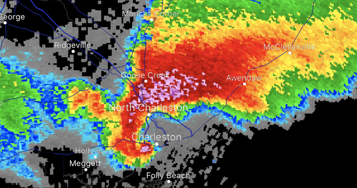
Charleston, SC EF3 Tornado[]
At 4:50 PM EST, a supercell produced a tornado near Hollywood, causing EF1 damage in the town. It moved northeast at 60 mph towards Charleston, striking the city as an EF2 with winds of 120 mph. It quickly intensified as it moved north, hitting North Charleston. It dissipated outside of Mt Pleasant, having killed only 2 people.
")
Mineral Wells, TX EF4 Tornado[]
At 5:32 PM CST, a supercell produced a tornado that touched down in Weatherford, hitting the town with EF1 damage right away. It tore through the western side of Weatherford as it gained intensity. Not too soon it gained an EF2 status as it moved along Mineral Wells Highway, causing high-end EF2 damage to cars on the highway. It then intensified into an EF3 as it struck the small town of Cool, ruining Cool. It hit the eastern part of Mineral Wells with high-end EF3 damage, ravaging the city. It tore through central Mineral Wells with intense EF4 destruction, blowing away houses and making debris fly everywhere. It hit western Mineral Wells with high-end EF3 damage to most of the buildings there. It then struck Palo Pinto with EF2 strength, then dissipated at 6:24 PM CST, having killed 45.
")
")
")
Tampa, FL EF2 Tornado[]
At 8:45 PM EST, a tornado touched down north of Land O' Lakes, causing EF0 damage there. It slowly moved south, hitting central Land O' Lakes with high-end EF0 damage, doing the same to the southern part of town. It hit the town of Lutz and Cheval with EF1 damage, causing minor damage. It struck Greater Northdale with 98 mph winds, causing high-end EF1 damage to Greater Northdale. Its next target was Greater Carrollwood, hitting the town with low-end EF2 damage to structures and trees. Then it hit northern Tampa with 125 mph winds, moderately damaging the part of town. It cut a swath of EF2 damage through Tampa, then moved into Hillsborough Bay, slowly dissipating as it headed further south. No one was killed even though the tornado hit a heavily populated area.
")
")
")
Day Six (December 29th, 2022)[]
Day six would be the last day of any hatched risks, with only a 30% risk for the midwest. Yesterday's previous southern system moved north, providing a new threat for the midwestern US. Hail was reported in 12 states and tornadoes only hit 9 states.
")
Rapid City, SD EF5 Tornado[]
This tornado was one of the 2 tornadoes to be classified as an EF5 today. At 11:15 AM MST, a large and violent supercell produced a tornado north of Sturgis. It immediately began to do EF2 damage to the structures in town and only got stronger as it entered Tilford. Tilford was struck by the now EF3 tornado, causing severe damage throughout the town. It still moved south on SD-79, hitting Piedmont next, causing EF4 damage to the town, devastating the town and killing 7. Then it hit Summerset with EF5 strength, annihilating the town. It moved south destroying Black Hawk, leveling the town. Then it hit the northwest part of Rapid City, flattening houses and high-rises, causing hundreds of millions of dollars in damage. It made a surprise turn southeast, directly hitting downtown Rapid City. High-rises were flattened to rubble and houses were swept off the foundation. It tore through southeastern Rapid City, although weakening to an EF4 as it left Rapid City. The last town the tornado would hit would be Green Valley, suffering EF3 damage. It dissipated at 12:10 PM MST 2 miles southeast of Green Valley. It killed 1,892 people.
")
")
")
St Paul, MI EF3 Tornado[]
This was another rare tornado that hit a metropolitan area. At 1:35 PM CST, a tornado watch was issued for Hennepin, Ramsey, and Dakota counties. This was only days after a monster EF5 hit Minneapolis, causing extensive damage and deaths. The same storm system that produced the Rapid City EF5 also produced this tornado as it touched down near Lakeville at 1:45 PM. Immediately, a tornado warning was issued for the three counties and the citizens were urged to take shelter. After what had happened just a few days ago, they did. Thankfully, this was only an EF3. The tornado first hit Lakeville, the town sustained EF0 damage for the most part, the northeast part recived EF1 damage. Soon, it did high-end EF1 damage to Apple Valley, 1 person was killed. Then, it hit Eagan with EF2 intensity, causing mild damage as 120 mph winds hit the town. People in St Paul braced for the full impact of the tornado, and soon it came at EF3 strength, causing severe damage to 70% of the buildings there. The tornado headed northeast out of St Paul, Minnesota's capital, at 2:10 PM. It began to rapidly weaken when it left St Paul. The last town it would hit was Little Canada, causing low-end EF1 damage before it dissipated. Only 8 people were killed thanks to the public knowing the true danger of tornadoes.
")
")
")
North Platte, NE EF4 Tornado[]
At 1:55 PM CST, a tornado warning was issued for Lincoln County, Nebraska. A supercell just dropped a tornado that immediately began to intensify, doing EF1 damage to the small town of Wallace. It moved northeast at a speed of 30 mph. Storm chasers were on I80 when the tornado hit Wallace. This tornado was odd, as it rapidly intensified in such a short time and path length. When it hit North Platte, it was already an EF3 with 150 mph winds. It hit the southern side with high-end EF3 damage, causing severe and extensive damage. It only got stronger when it moved through the center of North Platte, finally intensifying into an EF4 with winds of 170 mph. The tornado soon left North Platte and then hit Stapleton, causing EF3 damage to the town. The tornado soon dissipated 5 miles away from Stapleton. It killed 15 people in North Platte.
")
")
")
Chicago, IL EF1 Tornado[]
This was one of the weak tornadoes that hit a very big city. At 3:35 PM CST, residents of Cook County recived a tornado warning. To their relief, this was not one of the deadly twisters. The tornado touched down right in the middle of the Chicago metro, touching down in Bedford Park, heading northeast towards the center of Chicago. The tornado had peak winds of 105 mph as it hit downtown Chicago. Minor damage was seen and soon the tornado dissipated as it entered Lake Michigan. No one was killed.
")
")
Joj Col's Outbreaks and Tornadoes
| |
|
Discontinued |
Christmas Week Outbreak of 2022 • 2000 Valentine's Day Outbreak • Tornadoes of 2035 (Soviet Onion) |
|---|---|
|
Completed |
1984 June 12th Outbreak • Cincinnati-Cleveland, Ohio Tornado of 2018 • 1968 Outbreak of May 28th • Tornadoes of 2034 (Soviet Onion) |
Joj Col's Tornado Seasons
| |
|
Soviet Onion |
|
|---|---|
|
United States |
1900 • 1901 • 1902 |