 | |
| Type: | Tornado outbreak |
| Active: | June 8-11, 2020 |
| Duration of tornado outbreak1: | 3 days, 3 hours, 28 minutes |
| Maximum rated tornado2: | EF4 tornado |
| Highest winds | Unknown |
| Tornadoes confirmed: | 142 |
| Damage: | $2.66 billion (2020 USD) |
| Injuries: | 479 |
| Fatalities: | 36 |
| Areas affected: | North Dakota, South Dakota, Minnesota, Wisconsin, Illinois, Indiana, Michigan, Ohio |
|
1Time from first tornado to last tornado | |
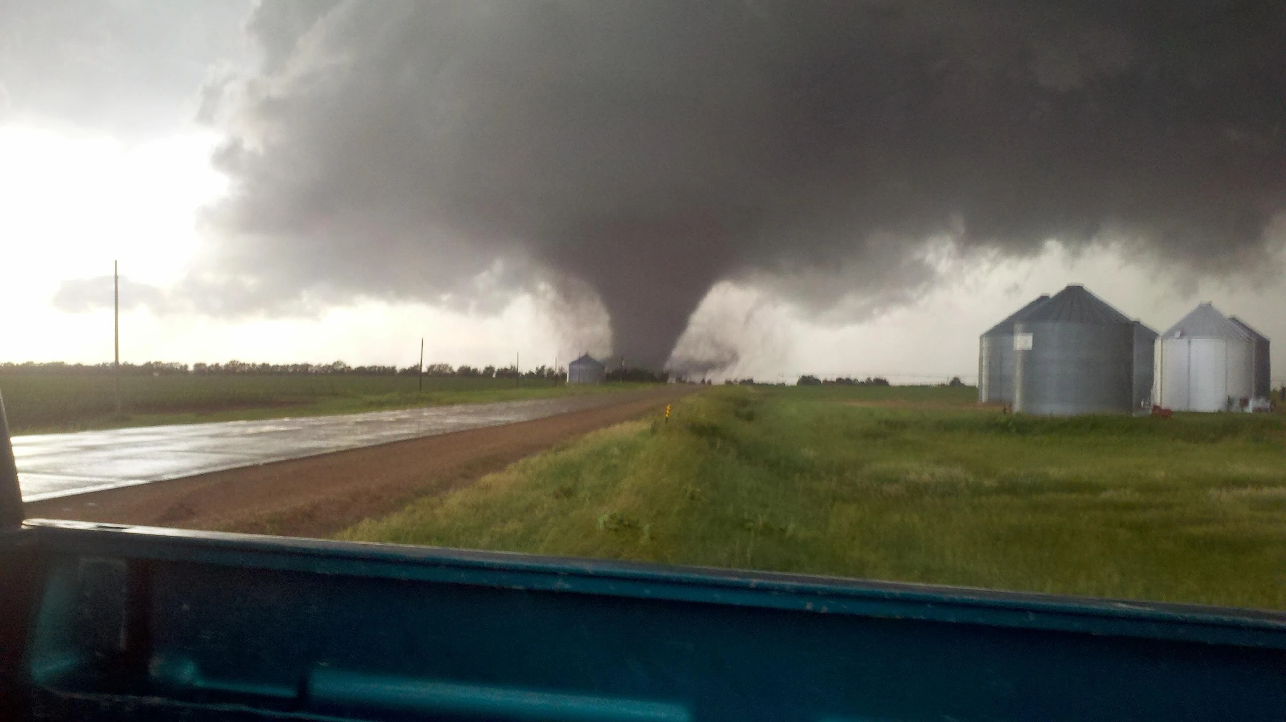
The tornado outbreak of June 8-11, 2020 was a four day severe weather event that produced numerous significant tornadoes across the Upper Midwest. 39 people died in the outbreak, and it left $2.66 billion in damages. It joins similar outbreaks, such as the June 2, 1990 outbreak, June 16, 1992 outbreak, and June 17, 2010 outbreaks as one of the most intense June outbreaks ever recorded. 142 tornadoes were confirmed over the four day span, 13 of which were violent, making it one of the most active periods of tornadic activity on record. It is the only recorded instance of four straight days with violent (EF4+) tornadoes. Only five days in recorded history since 1950 had more violent tornadoes than June 9th.
Meteorological synopsis[]
June 8[]
As a powerful shortwave trough dropped into the northern United States and moved east-southeast, the stage was set for a multi-day tornado outbreak in the Upper Midwest. The Storm Prediction Center had every day on its 4-8 outlook marked for severe weather on June 5. June 8 featured high instability and good shear across the central and eastern portions of the Dakotas, but a cap that didn't erode until mid afternoon. The SPC had an enhanced risk with a 10% hatched tornado risk in place for much of central and east North Dakota and South Dakota, with a 5% risk extending into northern Nebraska. 24 tornadoes touched down on June 8, including one EF4 in South Dakota.
June 9[]
The most prolific day of the outbreak took place on June 9. A strong surface low was located near the North Dakota-Minnesota border, with a cold front draping down through west MN into northern IA. A warm front in central/north MN was also expected to be a focus for tornadic activity later that day. 0-1 km helicity was in the 250-400 m2/s2 range and MLCAPE exceeded 3,000-4,000 j/kg in some spots. The SPC issued a moderate risk with a 15% hatched tornado risk for much of central and southern MN, which was eventually upgraded to a high risk at the 1630z outlook. A PDS tornado watch was issued that afternoon and several long-tracked, intense supercells developed spawning 55 tornadoes, 35 of which were Rated EF2 or higher, including 8 EF4's. The high concentration of significant and long-tracked tornadoes on June 9 is fairly unique for June outbreaks and the region. After dark, storms congealed into an MCS, and several QLCS tornadoes occurred across Wisconsin, many of which were significant; one such tornado was rated EF4.
June 10[]
By the morning of June 10, the MCS from the previous night had weakened, and rapid destabilization occurred in north Illinois and southern Wisconsin. The surface low had moved southeast, now positioned in northeast Iowa. A moderate risk was issued with a 15% hatched tornado risk across the northern half of Illinois. While isolated supercells were anticipated in that region, the warm front in southern Wisconsin would also be a focal point for tornadic activity on June 10. Modest to good wind shear coupled with excellent instability allowed for 31 tornadoes to form, including two EF4's, one of which having a path length of about 91 miles. A high-end EF2 tornado tracked through western Chicago, as well. Activity became sloppy into the evening hours and another MCS formed, continuing through the night until weakening before dawn on June 11.
June 11[]
Another moderate risk for tornadoes was issued on June 11, this time for northwest Ohio. An enhanced risk extended into Central Ohio, where a more conditional, but still significant, tornado threat existed. The surface low on this day was located in extreme southwest Michigan, and the whole warm sector was primed for supercells and tornadoes that evening. Again, modest to good wind shear existed across northwest Ohio, northeast Illinois, and southern Michigan, with plentiful summertime instability. 32 tornadoes touched down, including two EF4's. The town of Monroeville, Indiana was hit by two separate tornadoes (an EF4 and an EF3) within an hour. New Albany, Ohio, which was hit by an historic EF5 tornado during the tornado outbreak of April 23, 2020, was hit again in this outbreak by a high-end EF3 tornado at dusk, severely hampering cleanup efforts which were still ongoing. Storms tapered off as the sun set, bringing an end to the outbreak.
Tornado Statistics[]
| State | Total | EF0 | EF1 | EF2 | EF3 | EF4 | EF5 |
|---|---|---|---|---|---|---|---|
| June 8 | 24 | 7 | 8 | 6 | 2 | 1 | 0 |
| June 9 | 55 | 11 | 9 | 17 | 10 | 8 | 0 |
| June 10 | 31 | 6 | 15 | 4 | 4 | 2 | 0 |
| June 11 | 32 | 12 | 8 | 5 | 5 | 2 | 0 |
| Total | 142 | 36 | 40 | 32 | 21 | 13 | 0 |
List of confirmed tornadoes[]
| State | Total |
|---|---|
| Minnesota | 18 |
| Illinois | 8 |
| Indiana | 5 |
| Iowa | 2 |
| Ohio | 2 |
| Michigan | 1 |
| Totals | 36 |
June 8 event[]
| List of confirmed tornadoes - June 8, 2020 | ||||||
|---|---|---|---|---|---|---|
| North Dakota | ||||||
| EF2 | S of Napoleon | Logan | 2147 | 7.2 mi | Stovepipe tornado. A farm home was severely damaged and one person was injured. Formed near the triple point in central North Dakota. | |
| EF1 | SW of Streeter to Medina | Stutsman | 2208 | 18.97 mi | Wedge tornado remained in mainly rural areas as it moved north-northeast, doing minimal damage to crops and downing power lines. Likely would have been rated higher if it impacted major structures. | |
| EF0 | E of Fort Yates | Emmons | 2213 | 4 mi | Weak tornado remained in open fields. | |
| EF3 | Jamestown | Stutsman | 2249 | 2.89 mi | Intense yet relatively short-lived tornado that formed along the warm front in east central North Dakota. Several homes and businesses were destroyed on the south side of town at mid-range EF3 strength, many with only interior walls left standing. 19 people were injured. | |
| EF1 | Linton area | Emmons | 2316 | 3.55 mi | A few mobile homes were damaged south of Linton and trees were downed. Spawned by the same supercell that produced the tornado east of Fort Yates. | |
| EF1 | N of Guyson | Logan | 2333 | 8.11 mi | Weak tornado remained in open fields. Two outbuildings were destroyed and a farm was damaged. | |
| EF0 | N of Guyson | Logan | 2338 | 1 mi | Satellite tornado observed by chasers to the previous event. Produced no damaged. | |
| EF0 | SW of Jud (1st tornado) | LaMoure | 0028 | 5 mi | Produced no known damage. Spawned by the Guyson supercell. | |
| EF1 | SW of Jud (2nd tornado) | LaMoure | 0032 | 0.8 mi | Occured simultaneously with the previous tornado. Three outbuildings sustained minor damage and telephone poles were downed before the tornado abruptly dissipated. | |
| EF2 | W of Daily | Barnes | 0112 | 9.5 mi | Dozens of trees were denuded and snapped in the area. A pick-up truck was rolled six times and a poorly constructed home was completely destroyed. | |
| South Dakota | ||||||
| EF4 | ENE of Java to SE of Hillsview | Walworth, Edmunds, McPherson | 2221 | 14.6 mi | Large and violent tornado. Caused severe ground scouring as it passed north of Bowdle, where an EF4 tracked in May 2010. Two farmsteads were completely swept away and a well-constructed home was flattened. Large farm equiptment was thrown over 200 yards and crushed beyond recognition. An isolated grove of trees was severely debarked, as well. | |
| EF3 | ENE of Hillsview to E of Long Lake | McPherson | 2258 | 25.12 mi | Touched down soon after the Java area EF4 lifted. Remained in open farmland for much of its lifetime, however a tractor was thrown over 250 yards and crushed. Several outbuildings were completely destroyed and grain bins were toppled and crushed. An irrigation pivot was also severely mangled. | |
| EF2 | WSW of Agar to SSE of Seneca | Sully, Potter, Faulk | 2312 | 37.35 mi | Long-tracked tornado that was on the ground for nearly an hour and a half, beginning in rural areas outside of Agar. Almost every building in Agar sustained some level of damage, the worst of which was rated EF2. The tornado didn't damage any other structures after hitting Agar, and continued in open fields until dissipating south of Seneca. | |
| EF0 | W of Fort Thompson | Lyman | 2320 | 1 mi | Brief tornado confirmed by chasers. | |
| EF0 | E of Winner | Tripp | 2345 | 2.51 mi | A patch of shrubs and an outbuilding sustained minor damage. | |
|
EF0 |
ENE of Winner | Tripp | 2349 | 3 mi | Began as the previous tornado was dissipating. Did no known damage. | |
| EF2 | Aberdeen | Brown | 2359 | 10.39 mi | Tornado began in fields southwest of Aberdeen and proceeded north-northeast. As it neared the west side of the city, a PDS tornado warning was issued. Several homes in the Derian Subdivision were severely damaged at high-end EF2 strength. To the northeast, numerous other homes sustained EF2 damage on the southwest side of Aberdeen. It crossed Route 12 and threw a parked car one block, as well as heavily damaging Lincoln Elementary School. Many more businesses and homes took damage on the northwest side of town before the tornado returned to rural areas north of the city, where the roof of the Odde Ice Arena caved in. It dissipated west of the Devian Villa Development, injuring 16 people and leaving $30 million in damages. | |
| EF2 | W of Stickney | Aurora | 0018 | 6.12 mi | Long-lived, large, nearly stationary wedge tornado. Began and immediately inflicted EF2 damaged to a farm home and several outbuildings. Turned north and passed very close to another farm house and did EF1 damage to it. At that point it stopped moving and grew to almost 1.5 miles wide, before looping around and denuding trees and destroying outbuildings just west of Stickney. 1 person was injured. | |
| EF1 | ESE of Seneca | Faulk | 0050 | 7.23 mi | Began shortly after the Agar EF2 lifted. A small farm was damaged and a car was pushed off of Route 212. | |
| EF1 | W of St. Lawrence | Hand | 0144 | 4.4 mi | A church and three homes were damaged as the tornado passed over Route 14 between Miller and St. Lawrence. The roof of the church was thrown about 200 yards to the northeast in a field. | |
| EF1 | Kampeska | Codington | 0251 | 12.4 mi | A few double wide homes sustained roof and garage damage in Kampeska. Several more homes were damaged on the west side of Lake Kampeksa, and three people were injured. Telephone poles were downed, as well. | |
| EF1 | N of Lake Kampeska | Tripp | 0335 | 1.68 mi | Outbuildings were damaged and several trees were downed. Formed as the Kampeska tornado dissipated. | |
| Nebraska | ||||||
| EF2 | Bassett area | Rock | 0134 | 5.88 mi | Slow-moving, large, high-end EF2 tornado that did significant damage to the southern half of Bassett. Several homes lost their rooves and some had only a few walls remaining. 8 people were injured. | |
| EF0 | N of Atkinson | Holt | 0217 | 0.2 mi | Local sheriff reported a tornado. Produced no known damage other than to crops. | |
June 9 event[]
| List of confirmed tornadoes - June 9, 2020 | ||||||
|---|---|---|---|---|---|---|
| Minnesota | ||||||
| EF0 | E of Forada | Douglas | 1837 | 1.34 mi | Short-lived tornado confirmed by law enforcement. A few trees were downed, but damage was otherwise minimal. | |
| EF3 | S of Danvers to Benson to Swift Falls | Swift | 1909 | 18 mi | This EF3 tornado began south of Danvers in rural areas. It quickly grew into a large multi-vortex wedge tornado and completely destroyed a farm house and outbuildings near it. Trees were slightly debarked as it crossed the Chippewa River and neared Benson. It entered the southern part of Benson where several homes were left with only interior walls standing, and grain bins were toppled. Two homes on 10th street were nearly flattened. A few businesses on Route 12 sustained significant damage, and a farming plant east-northeast of town was heavily damaged. It continued northeast through rural areas until dissipating near Swift Falls. | |
| EF1 | E of Cormorant | Otter Tail, Becker | 1918 | 9.3 mi | This high-end EF1 tornado formed near the triple point. It inflicted severe roof damage to homes as it moved north-northeast and crossed Pelican Lake. Numerous trees were uprooted as well. | |
| EF2 | W of Fulda to S of Westbrook | Murray, Cottonwood | 1933 | 13.77 mi | EF2 tornado that damaged or destroyed several farms and outbuildings early in the track. A large, well-built home on Route 59 had an exterior wall demolished. The tornado became a multi-vortex wedge and did minor damage to a few other outbuildings, as well as downing and snapping power lines and trees, before lifting south of Westbrook. | |
| EF0 | SSE of Milroy | Redwood | 1954 | 1.92 mi | Short-lived tornado did limited damage in open areas. | |
| EF4 | Cottonwood to Wood Lake to N of Olivia | Lyon, Yellow Medicine, Renville, Kandiyohi | 2003 | 40.72 mi | 4 deaths - violent, high-end EF4, large stovepipe tornado. The tornado touched down in eastern Cottonwood and rapidly intensified to high-end EF2 strength, severely damaging several homes and denuding and uprooting trees. Two farm in complexes northeast of town were also heavily damaged. It continued northeast and entered Wood Lake. Two well-constructed homes were completely leveled with debris pushed off their foundations, and several other homes sustained EF3 damage. Parts of the roof from St. John's Lutheran Church were found 15 miles northeast in a field. Slight wind-rowing of debris was noted northeast of town, where trees were also debeaked. No significant structures were damaged for quite some time as the tornado continued northeast towards Renville. There, the worst damage occurred. A dozen homes were swept away on the southwest side of town, although they were found to have nailed rather than bolted to their foundations. Cars were thrown up to 350 yards and wrapped around debarked trees. A large home was partially swept away on 3rd Street SE. A large industrial complex northeast of town was narrowly missed. Eventually the tornado crossed Route 71 and dissipated north of Olivia. It was on the ground for just over 1 hour and 20 minutes. | |
|
EF0 |
SSW of Brooten | Pope | 2007 | 0.66 mi | Brief tornado spawned by the Danvers supercell. | |
| EF1 | Gracelock area | Chippewa | 2019 | 4.08 mi | Trees were downed and a home sustained minor roof damage. | |
| EF3 | SSE of Seaforth to NNE of Franklin | Redwood, Renville | 2020 | 24.14 mi | A supercell that was developing south of the Milroy supercell eventually cut it off and went on to produce this EF3 tornado. A few homes were damaged or destroyed in eastern Redwood County and outbuildings were swept away. It missed Redwood Falls just to the south and east continuing to do EF2 to occasional EF3 damage. Hardwood trees were debarked as it approached Morton from the southwest. 80% of the town sustained some sort of damage. The worst was rated EF3, as poorly constructed homes were totally leveled and others had only interior walls remaining. Large grain bins were toppled and crushed, with one being pushed over 100 yards. It eventually weakened north of Franklin in open fields. | |
| EF2 | Grey Eagle | Todd | 2028 | 3.54 mi | Several homes and businesses were severely damaged in the area. Power lines were downed or snapped. Part of a roof was found in Trace Lake. | |
| EF3 | Pine River/Chickamaw Beach | Cass | 2035 | 6.98 mi | Low-end EF3 tornado did severe damage in the Pine River/Chickamaw Beach area. Hundreds of trees were snapped and the Pine River High School lost much of its roof. Several homes on the bank of Norway Lake were destroyed and several other trees were downed or snapped. 13 people were injured. | |
| EF1 | Greenwald area | Stearns | 2037 | 5.39 mi | 1 death - weak tornado spawned by the Danvers supercell. One person was killed when a tree fell on their mobile home. | |
| EF2 | S of Cobden to SSW of Lafayette | Brown, Nicollet | 2048 | 22.94 mi | Strong wedge tornado damaged or destroyed several buildings in rural areas of Brown and Nicollet County. Several trees were uprooted or snapped as it crossed the Minnesota River. It injured one person and was spawned by the Fulda supercell. | |
| EF3 | W of Osakis to Browerville to NE of Motley | Douglas, Todd, Morrison, Cass | 2055 | 50.2 mi | Long-tracked intense tornado. Originated west of Osakis and proceeded sharply to the northeast crossing Lake Osakis. EF1 to low-end EF2 damage was noted to homes along the lake. To the northeast, farms and outbuildings were destroyed, and a few poorly anchored structures were mostly swept away. It turned a bit more to the north and reached peak intensity on the east side of Browerville. Over a dozen houses were flattened at high-end EF3 strength. Along Horseshoe Lake, trees were slightly debarked and snapped and a small boat was tossed nearly 100 yards. At this point it became heavily wrapped in rain and weakened quite a bit, doing mainly EF1 damage to trees and outbuildings. It eventually reached Motley, where high-end EF2 to EF3 damage occurred again to buildings on the western half of town. It entered Cass County and dissipated shortly afterwards. | |
| EF3 | N of Olivia to SE of Buffalo | Renville, Meeker, McLeod, Wright | 2117 | 65.12 mi | As the Renville EF4 was ending, the same supercell produced another long-tracked intense tornado. No significant structures were damaged in Renville County, but a farm was completely leveled as it passed south of Cosmos. It clipped the northwestern tip of McLeod County where severe tree damage occurred, before reentering Meeker County. Homes along the southern shore of Lake Jennie were heavily damaged or completely destroyed. To the northeast, the north side of Howard Lake took significant damage at EF2 strength. It continued to do tree damage as it passed south of Buffalo and eventually dissipated 2 hours and 10 minutes after touching down. | |
| EF0 | NE of Rice | Benton, Morrison | 2135 | 10.32 mi | Weak tornado lightly damaged a few homes and knocked branches off trees. | |
| EF1 | SE of Lafayette | Nicollet | 2136 | 5.67 mi | Trees were downed and a farm was damaged. | |
| EF4 | New Auburn | Sibley, McLeod | 2150 | 17.43 mi | Violent tornado began south of Fernando. Farms, outbuildings, and a few homes were damaged or destroyed as it moved northeast towards New Auburn. A tornado emergency was issued as it approached. Southwest of town, a poorly anchored home was completely swept from its foundation. The southern half off the small town took a direct hit at high-end EF3 to low-end EF4 strength. Trees were debarked and snapped and homes were flattened. Debris from a home on the west shore of High Island Lake was pushed 50 yards off its foundation and into the lake. Past the lake, the tornado gradually weakened and dissipated. | |
| EF2 | N of Gilman to WNW of Mora | Benton, Mille Lacs, Kanabec | 2151 | 28.83 mi | Strong tornado with a maximum width of about a mile. Hundreds of trees were uprooted or snapped making the path and a few double wide homes were destroyed. | |
| EF2 | N of Green Isle | Sibley, Carver | 2229 | 6.39 mi | Several homes and outbuildings were damaged or destroyed in the area. A car was rolled three times and a 2x4 was thrown through the side of a mobile home. | |
| EF1 | New Prague area | Le Sueur, Scott | 2234 | 17.7 mi | Several homes and businesses sustained roof damage in the New Prague area. | |
| EF3 | WNW of Carver to Chaska to Richfield | Carver, Hennepin | 2300 | 22.25 mi | 2 deaths - Initially rated EF4 but was later downgraded. Many homes in Chaska were completely destroyed and a few were nearly completely flattened. Hundreds of trees were uprooted, snapped, or partially debarked along the path. Two people were killed in a subdivision southwest of Eden Prairie. A tornado emergency was issued as it continued to rip through heavily populated suburbs of southern Minneapolis. Widespread EF2 to EF3 damage was noted in a 50 to 100 yard wide swath for much of the path. Eventually it began to weaken and dissipated near the city of Richfield. It was one of the costliest tornadoes of the outbreak. | |
| EF4 | S of St. Michael | Wright, Hennepin | 2321 | 11 mi | Several homes were destroyed by this tornado. Three people were injured in a subdivision northeast of Hanover when their home was partially swept away. Numerous trees were debarked. | |
| EF2 | SSE of Hanover | Wright, Hennepin | 2325 | 3.12 mi | Strong satellite tornado to the previous event. Though relatively short-lived, this tornado destroyed a frame home and snapped several trees before swinging sharply north and dissipating. | |
| EF1 | Eden Prarie area | Hennepin | 2326 | 1.02 mi | Satellite to the Chaska EF3. | |
| EF2 | ENE of East Lake | Aitkin | 2340 | 8.25 mi | Hundreds of trees were denuded, uprooted, or snapped. | |
| EF0 | Mendota Heights | Dakota | 2346 | 0.89 mi | Several homes and businesses sustained minor roof damage. | |
| EF0 | SE of Flom | Norman | 0012 | 2.24 mi | Brief tornado confirmed by sheriff. No damage was found. | |
| EF2 | Amboy/Mapleton | Blue Earth | 0025 | 12.41 mi | A few homes were damaged. One house had its entire second floor removed as well as two exterior walls. A 2x4 was thrown through the windshield of a car nearby. Trees were snapped and two trucks were flipped and rolled short distances. | |
| EF4 | Rochester to NE of Elba | Olmsted, Wabasha, Winona | 0051 | 30.32 mi | 3 deaths - violent tornado spawned by the Spencer-Swea City-Albert Lea supercell. The tornado began in northwest Rochester and proceeded east-northeast into heavily populated areas of the city. Several homes and businesses sustained EF2 damage as it moved through the Elton Park and Viking Hills subdivisions, where one person was killed. The tornado rapidly intesified to EF4 strength in the Glendale subdivision, where trees were snapped and debarked and a few homes were completely flattened or partially swept away. In one case only some debris and an open basement was left. Large homes in the Emerald Hills area were destroyed at EF3 strength as the tornado reached its maximum width of one mile wide. Debris was scattered in fields to the northeast. Another large home off of Hidden Hills Lane was completely flattened at EF4 intensity. No significant structures were damaged as it continued northeast and passed between Elgin and Viola. Several trees were downed as the tornado began to weaken and dissipated northeast of Elba. | |
| EF3 | NW of Preston | Fillmore | 0129 | 9.22 mi | A large home lost much of its second story, and the home's detached garage was completely swept away, however it was very poorly built. Several trees were denuded, snapped, or partially debarked. | |
| Iowa | ||||||
| EF1 | N of Royal | Clay | 2018 | 2.1 mi | An outbuilding sustained moderate damage. This was the first of several tornadoes spawned by a long-tracked supercell that moved through north Iowa and southern Minnesota. | |
| EF4 | Spencer | Clay | 2029 | 11.68 mi | 2 deaths - violent, devastating tornado with estimated wind speeds of 180 mph that moved through Spencer. It began shortly after the previous tornado ended in fields southwest of Spencer. Chasers noted that it became visibly violent as it approached the city. The now violent stovepipe was doing moderate ground scouring and a tornado emergency was issued for Spencer. It entered the southwest side of the city, debarking trees and leveling a well built home, where an EF4 rating was applied. Continuing northeast, EF3 damage was noted to several homes just south of the town center. Trees were snapped and debarked. An SUV was thrown 350 yards and landed in a nearby parking lot. A few buildings at an industrial complex sustained EF4 damage, being mostly destroyed with only a pile of debris left behind. It reentered rural areas and swept away a farm before dissipating in northeast Clay County. It cost an estimated $85 million in damages. | |
| EF2 | NE of Spencer to WNW of Graettinger | Clay, Palo Alto, Emmet | 2056 | 8.71 mi | Began shortly after the Spencer EF4 ended. Cone tornado remained in mainly rural areas but snapped a few trees, damaged some farm homes, and destroyed several outbuildings. | |
| EF0 | NE of Graettinger | Emmet | 2119 | 3.25 mi | Weak tornado remained in open fields and did no damage. | |
| EF2 | W of Ringsted to SW of Swea City | Emmet, Kossuth | 2122 | 11.43 mi | A farming complex and several outbuildings were destroyed. Preceded an EF4 that did significant damage in the Swea City area. | |
| EF4 | Swea City area | Kossuth | 2153 | 4 mi | Short lived yet violent tornado that formed as the previous tornado dissipated. 80% of town was damaged, 50% being destroyed. The most severe damage was rated EF4 with estimated winds of 170 mph, as three homes were flattened. A small vehicle was picked up and thrown over the rooves of three homes before smashing into another. 42 people were injured. | |
| EF2 | SE of Swea City | Kossuth | 2156 | 7.08 mi | Satellite tornado to the Swea City EF4 that eventually cut it off. An outbuilding was flattened and a barn sustained significant damage. | |
| EF1 | SW of Ledylard to SW of Rake | Kossuth, Winnebago | 2207 | 14.78 mi | Stovepipe tornado didn't impact many significant structures along its path, but a barn and a shed were destroyed. | |
| EF4 | Rake to Albert Lea (MN) to S of Byron (MN) | Winnebago, Faribault (MN), Freeborn (MN), Mower (MN), Dodge (MN), Olmsted (MN) | 2235 | 73.67 mi | 8 deaths - Very high-end EF4 wedge tornado, considered one of the most violent of the outbreak. Originated in extreme north Iowa near the Minnesota border as the previous tornado ended, and moved into Minnesota. EF1 to EF2 damage was produced in southeastern Fairbault County, where several outbuildings were damaged. It passed near Conger, where a similar EF4 passed through on June 17, 2010. Rapid intensification occurred west of Albert Lea, where a poorly built home was leveled, killing the occupant. It entered the west side of Albert Lea, where a relatively newly constructed subdivision of large, well-built homes sustained EF4 damage. Homes there were leveled or partially swept away. It continued northeast through heavily populated subdivisions of northern Albert Lea where homes continued to sustain EF2 to EF4 damage. It reached peak intensity shortly before crossing I-35, as a large home with anchor bolts was completely swept away leaving only an open basement. Cycloidal ground swirls were noted in open fields of eastern Freeborn County, with wind-rowing of debris also noted. Few structures were damaged for quite some time after that, as it remained in fairly rural areas. Trees were debarked east of Route 218. Hayfield was hit at high-end EF3 strength, with several homes left with few interior walls standing or being flattened. It lifted south of Byron in western Olmsted County. | |
| EF3 | W of Rands (1st tornado) | Calhoun | 0056 | 9.12 mi | Extremely large wedge tornado with a maximum width of 1.5 miles. A poorly-constructed farmstead was completely swept away. | |
| EF0 | W of Rands (2nd tornado) | Calhoun | 0101 | 2.76 mi | Satellite tornado to the previous event. | |
| Wisconsin | ||||||
| EF0 | W of Rands | Washburn | 2254 | 4.23 mi | Several trees lost their limbs or were toppled. | |
| EF2 | Cameron | Barron | 0039 | 1.98 mi | A few homes were damaged in the area. A car was overturned and several trees were uprooted or snapped. | |
| EF0 | NW of Medford (1st tornado) | Taylor | 0235 | 2.31 mi | A few trees were uprooted. | |
| EF2 | NW of Medford (2nd tornado) | Taylor | 0243 | 7.1 mi | Significant tree damage occured and a single wide home was mostly destroyed. Because of significant straight-line wind damage in the area, certain parts of the track were difficult to delineate. | |
| EF0 | NW of Medford (3rd tornado) | Taylor | 0244 | 0.49 mi | Trees lost large limbs. | |
| EF2 | W of Stratford | Marathon | 0255 | 4.97 mi | Trees were snapped and a dairy facility lost its roof and two outer walls. | |
| EF2 | Hewitt area | Wood | 0255 | 10.11 mi | Occurred simultaneously with the previous tornado a few miles south. EF2 damage was noted to several buildings and a church on Main Street. Two people were injured. | |
| EF4 | NNW of Lyndon Station | Juneau | 0322 | 8.94 mi | Low-end EF4 tornado did very significant tree damage; complete debarking was noted to several trees in the area. Additionally, a frame home was mostly flattened east of I-90. A car was thrown several hundred feet from the house, as well. | |
| EF3 | Nelsonville | Portage | 0350 | 12.02 mi | Several homes and a warehouse were destroyed in southern Nelsonville. Early warnings prevented any deaths, but several people were injured. | |
| EF3 | Amherst Junction area | Portage | 0401 | 2.58 mi | As the previous tornado was moving through Nelsonville, another intense tornado was spawned by an embedded supercell in the squall line further south. Although brief, this tornado flattened several homes just north of Amherst Junction, although they lacked anchor bolts. Four people were injured in that neighborhood. A car was also tossed about 100 yards and smashed into a yard nearby. | |
| EF1 | ESE of Tomahawk | Lincoln | 0417 | 3.75 mi | Severe trees damage occurred in the area. | |
| EF2 | S of New London | Outagamie, Waupaca | 0428 | 6.97 mi | Severe tree damage occurred in the area. One person was injured when a tree fell on to their house. | |
| EF2 | W of Winneconne | Winnebego | 0432 | 5.11 mi | Tornado paralleled the southern shore of Lake Poygan, damaging seven well-built homes, all of which had their rooves or second stories removed. Numerous trees were uprooted or snapped in the area, as well. Nine people were injured. | |
June 10 event[]
| List of confirmed tornadoes - June 10, 2018 | ||||||
|---|---|---|---|---|---|---|
| Wisconsin | ||||||
| EF1 | Menomonee Falls | Waukesha | 0534 | 1.38 mi | Several homes and trees sustained minor damage from this brief tornado. | |
| EF0 | W of Fennimore | Grant | 1546 | 0.89 mi | Brief tornado took large limbs off several trees. | |
| EF1 | E of Shullsburg | Lafayette | 1952 | 10 mi | Numerous trees were uprooted along the path. Power poles were downed, as well. | |
| EF2 | W of Ridgeway | Iowa | 2004 | 4.87 mi | A mobile home was tossed a short distance and rolled three times. Trees were snapped and two homes were destroyed. | |
| EF0 | Ixonia area | Grant | 2011 | 0.09 mi | Very brief tornado did minimal damage to trees and a home, which has some siding removed. | |
| EF3 | N of Ridgeway | Iowa | 2025 | 9.88 mi | Low-end EF3 tornado did heavy damage to hundreds of trees and rolled a trailer several times. Two mobile homes were disintegrated. This tornado closely paralleled the path of an F5 that impacted Barneveld in 1984. | |
| EF2 | Stoughton | Dane | 2114 | 16.65 mi | Several homes and businesses in southeastern Dane county were destroyed by this EF2 tornado. In Stoughton, numerous homes were severely damaged or destroyed, losing rooves and exterior walls. Several trees were snapped along the path, as well. | |
| EF3 | Palmyra area | Walworth, Jefferson | 2157 | 10.17 mi | Several trees were denuded and slightly debarked by this tornado. Just west of Palmyra, an industrial complex was severely damaged, losing its roof and a few outer walls. Three nearby houses were left with only a few interior walls, and cars were tossed up to 80 yards. Damage in the area was rated EF3. The tornado turned north and weakened shortly after hitting town. | |
| EF1 | W of Fox Lake | Dodge | 2220 | 3.6 mi | Weak tornado damaged five homes and a deli, and damage was mostly to rooves of the impacted buildings. | |
| EF1 | N of East Troy | Walworth | 2258 | 2.79 mi | Many trees were downed and the roof of one home was heavily damaged. | |
| EF1 | NW of St. Nanianz | Manitowoc | 0025 | 2.39 mi | Brief tornado downed trees, power lines, and lightly damaged two homes. | |
| Illinois | ||||||
| EF4 | NE of Thomson to Carpentersville | Carroll, Ogle, DeKalb, Kane | 2011 | 91.18 mi | 1 death - This large and violent wedge tornado had the longest path length of any tornado in this outbreak. Spawned by the first of two long-tracked cyclical supercells in north Illinois, it began northeast of Thomson inflicting EF0 and EF1 damage to trees and homes. It rapidly intensified to EF3 strength as it moved past Ideal, were a barn was blown off its foundation and trees were debarked. It continued east-northeast maintaining EF2 strength passing through rural areas of Ogle County. The first instance of EF4 damage occurred northwest of Milledgeville, where a farm home was completely disintegrated and blown off its foundation. A tractor from the location was hurled 170 yards. Nearby, grain bins were toppled and crushed. Ground scouring was noted as well as slight wind-rowing of debris. Similar damage was noted to a home on Eagle Creek, where a home was completely flattened and trees were debarked. Two outbuildings on the property were swept away, as well. On S Summer Hill Road, an old, unanchored house was picked up off its foundation, carried 80 yards, and smashed into the ground, killing a man inside. Southwest of Mt. Morris, it re-intensified to EF4 again, completely debarking trees and sweeping away a large house. Southeast of town, it became a high-end EF4, leveling or sweeping away several homes, tossing a car over 200 yards, and debarking and snapping trees. It reached peak strength as it passed through the northern tip of Oregon, where it completely swept away several large, well-anchored homes at borderline-EF5 intensity. Granulated debris was pushed east into debarked trees. On the shore of the Rock River, several houses were flattened, and one was pushed off its foundation into the river. It weakened to EF2 strength and re-entered rural areas. It narrowly missed the town of Holcomb to the south, although one house lost its second story, where an EF3 rating was applied. To the east, ground scouring was noted, and as the tornado crossed I-39 it scoured pavement from the highway. South of Fairdale, where a similar EF4 passed through in April 2015, a house sutained low-end EF3 damage. Low-end EF4 damage occurred in a subdivision west of Kirkland, where several houses were flattened and left as piles of rubble. EF2 to EF3 damage was noted to many homes and businesses on the northern tip of town. It intesified to high-end EF4 intensity again northwest of Kingston, where again numerous homes were flattened or partially swept away. North of Genoa, two homes were destroyed at EF2 strength. No significant structures were damaged for some time after that. An industrial facility lost its roof and an outer wall at EF3 strength as the tornado neared Huntley. A tornado emergency was issued as it moved into heavily populated residential areas of Huntley, where widespread EF4 damage occurred, as several homes were leveled. Cars were thrown long distances and trees were debarked. The tornado gradually began to weaken as it moved east, crossing I-90 and eventually dissipating near Carpentersville. It was on the ground for roughly 3 hours and is considered one of the strongest tornadoes of this outbreak, along with the Albert Lea EF4 on June 9th. There was a dispute over the rating of this tornado, as one survey team found EF5 damage. Due to contextual discrepancies and doubt over the structural integrity of certain buildings, the EF4 rating was maintained. | |
| EF1 | N of Tampico | Whiteside | 2046 | 13.5 mi | Telephone poles were downed and outbuildings were heavily damaged. The supercell that spawned the tornado went on to produce several more significant tornadoes across northern Illinois. | |
| EF3 | The Burg to NW of Kaneville | Lee, DeKalb, Kane | 2148 | 25.3 mi | 1 death - this high-end EF3 tornado did significant damage along the path. A house just west of I-39 was completely flattened, with pieces of the roof found hundreds of yards to the east. One person was killed at the location. The tornado continued east-northeast through mostly rural areas destroying a few homes and buildings before lifting. | |
| EF1 | N of Ipava | Fulton | 2158 | 4.51 mi | Two farm homes were lightly damaged by this tornado. | |
| EF0 | SW of Lena | Stephenson | 2210 | 1.91 mi | A few trees were downed. | |
| EF2 | Wenmoth Acres to WNW of Winfield | Kane, DuPage | 2253 | 8.79 mi | Numerous homes were severely damaged or destroyed by this rain wrapped tornado. A building in an industrial complex sustained damage to its roof. | |
| EF0 | NE of Wheaton | DuPage | 2309 | 1.99 mi | Several homes suffered light damage from this brief and weak tornado. | |
| EF2 | NNE of Glen Ellyn to Franklin Park to SE of Norridge | DuPage, Cook | 2316 | 15.11 mi | 4 deaths - Initial damage from this high-end EF2 tornado was light. Upon crossing I-355, the tornado grew to nearly a half mile wide and inflicted near-EF3 damage to several homes. It moved through heavily populated subdivisions of Western Chicago, passing south of O’Hare International Airport, doing the heaviest damage in Franklin Park, where numerous homes were destroyed. It rapidly weakened and dissipated shortly thereafter. | |
| EF4 | Seneca | LaSalle, Grundy | 2347 | 5.62 mi | 2 deaths - Upon touching down just south of the Illinois River, this tornado rapidly intensified. It exhibited multi-vortex structure as it approached Seneca, and trees to the west of town were slightly debarked. The fire department was leveled, and several businesses on the north side of Seneca were demolished. Several homes in the Valley View subdivision were left with only interior walls or were completely flattened. Debris was thrown into nearby fields. After continuing northeast, the tornado became heavily rain-wrapped and dissipated. | |
| EF0 | Morris area | Grundy | 2351 | 0.84 mi | Street signs were bent and six homes lost shingles. | |
| EF1 | WNW of Wapella | DeWitt | 0013 | 4.84 mi | Highly visible stovepipe tornado. Remained in mostly open areas, but one outbuilding was destroyed. | |
| EF3 | NE Wapella to W of Bellflower | DeWitt, McLean | 0026 | 11.44 mi | Following the previous event, the same supercell spawned this intense wedge tornado. Along the path, three poorly built farm homes were completely leveled, one of which was pushed off its foundation. | |
| EF1 | NW of Colfax | McLean | 0035 | 2.5 mi | Large yet weak tornado ripped the rooves off a few homes in the area. Two people were injured. | |
| EF1 | Campus to Buckingham | Livingston, Kankakee | 0049 | 7 mi | Few structures were impacted by this tornado, but one home did sustain heavy roof damage. | |
| EF0 | SE of Peotone to W of Beecher | Will | 0123 | 4.57 mi | Two homes sustained very light damage. Otherwise this tornado remained in rural areas. | |
| Michigan | ||||||
| EF1 | W of Manton | Wexton | 0105 | 3.12 mi | Three homes sustained major roof damage. One person was injured. | |
| EF1 | Niles area | Berrien, Cass | 0155 | 5.1 mi | This tornado moved through heavily populated subdivisions of southeast Niles. Many homes sustained heavy damage, and nine people were injured. | |
| Indiana | ||||||
| EF1 | WNW of Star City | Pulaski | 0257 | 6.01 mi | Damage was limited, but a farm home was impacted and nearby grain bins were heavily damaged. | |
| EF1 | Chalmers | White | 0307 | 2.95 mi | Weak tornado moved through Chalmers, tearing roofs off over a dozen homes. Seven people were injured. | |
| EF1 | WNW of Lebanon | Boone | 0319 | 7.22 mi | Trees were uprooted along the path. A towing plant sustained minor damage a tornado the end of the path. | |
June 11 event[]
| List of confirmed tornadoes - June 11, 2020 | ||||||
|---|---|---|---|---|---|---|
| Indiana | ||||||
| EF0 | SE of Lagrange | Lagrange | 0645 | 0.97 mi | Three Homes sustained very light damage. | |
| EF0 | Waynetown | Montgomery | 1528 | 3.05 mi | Shingles were torn off homes and street signs were bent. | |
| EF2 | E of Lebanon | Boone | 2031 | 4.3 mi | Following a tornado in Boone County the previous night, this one struck just miles away on June 11. Several homes sustained severe damage. Outbuildings were demolished. | |
| EF1 | Peru area | Miami | 2044 | 2.8 mi | Mobile homes were rolled on Riggle Road. Tree shop were downed and many homes were damaged. | |
| EF0 | SSW of Lagro | Wabash | 2112 | 1.59 mi | Weak Tornado did very limited damage to outbuildings. | |
| EF3 | ENE of Berne | Allen | 2129 | 9.6 mi | Several outhouses and farm homes were destroyed by this low-end EF3 tornado. A tractor was tossed and rolled about 200 yards. One farm home was reduced to nothing but its interior bathroom, although the home was of poor construction. | |
| EF4 | WSW of Monroeville (IN) to SW of Haviland (OH) | Allen (IN), Van Wert (OH), Paulding (OH) | 2148 | 16.77 mi | 5 deaths - violent high-end EF4 tornado. Tornado began near Monroeville, where it quickly intensified and moved into a subdivision on the southwest side of town. Here, all five deaths occurred as extreme damage was noted. Three homes were cleanly swept away, and about a dozen others were reduced to rubble. At least one home had possible EF5 damage, but nearby shrubs were untouched; contextual discrepancies prevented a higher rating. Numerous buildings sustained EF2 to EF4 damage as the tornado continued east-northeast. The St. Rose Catholic Church was completely destroyed. As the tornado exited Monroeville moved into Ohio, a grove of trees was debarked. Wind rowing of debris was noted in southwest Putnam County. The tornado dissipated as it approached Haviland. The southern part of Monroeville would be hit again by an EF3 tornado about an hour later. | |
| EF0 | E of New Castle | Henry | 2226 | 2.29 mi | Trees were downed and a few buildings sustained light damage. | |
| EF3 | NW of Boston Corner to NE of Monroeville | Allen | 2237 | 4.45 mi | Brief but intense tornado. This was the second tornado to hit Monroeville on June 11, following the EF4. Moving northeast, the tornado moved through rural areas, inflicting EF2 damage to a farmhouse on Flatrock Road. The tornado then intensified as it impacted the southern portion of Monroeville, where a complex of manufactured homes was completely destroyed at low-end EF3 strength. One person sustained an injury. The tornado dissipated to the northeast of town shortly thereafter. This tornado impacted the southern edge of town, whereas the first tornado was stronger and impacted Monroeville much more directly. | |
| EF0 | NE of Hamilton | Steuben | 2250 | 3.8 mi | Very light damage occurred in the area. The supercell that spawned this tornado went on to produce two strong tornadoes, both in Ohio and Michigan. | |
| Michigan | ||||||
| EF1 | Lake Fenton | Genesee, Oakland | 0827 | 4.71 mi | QLCS Tornado damaged numerous homes and downed several trees. | |
| EF3 | NW of Bronson | Branch | 2128 | 4.79 mi | Intense tornado did severe damage in the area. Trees were snapped, a grain bin was toppled, and two homes were demolished. Three people were injured. | |
| EF0 | Battle Creek | Calhoun | 2137 | 5.69 mi | Several homes in southwestern portions of Battle Creek sustained light damage to roofing and siding. | |
| EF2 | NE of Coldwater | Branch | 2150 | 6.7 mi | Severe tree damage occurred in the area, and three houses on Jonesville Road were completely destroyed. Two people were injured. | |
| EF1 | N of Parma | Jackson | 2219 | 7.01 mi | Numerous trees were downed and a few houses were damaged. | |
| EF2 | N of Waldron to N of Adrian | Hillsdale, Lenawee | 2338 | 22.4 mi | 1 death - this tornado began shortly after the Pioneer, Ohio tornado lifted. Upon touching down this tornado quickly strengthened to high-end EF2 strength, completely destroying a few outbuildings and denuding trees. It grew to a large, rain-wrapped wedge and moved into the town of Clayton, where high-end EF2 damage was again noted, with six homes being completely destroyed. One person was killed in the town. The tornado persisted into open areas and weakened considerably, before dissipating. | |
| EF0 | SSW of Dundee | Henry | 2350 | 1.21 mi | Weak tornado inflicted light roof damage to homes along the River Raisin. | |
| EF0 | NNW of Stockbridge | Ingham | 0011 | 2.2 mi | A farm sustained roof damage and various trees lost large limbs. | |
| Ohio | ||||||
| EF4 | NE of Van Wert to Ottoville | Van Wert, Putnam | 2201 | 10.65 mi | 1 death - large wedge tornado with estimated winds of 170 mph. While mostly moving though rural areas, the tornado did completely flatten a farming complex near Dog Creek, killing the inhabitant. A few other homes sustained EF2 to EF3 damage along the path before the tornado dissipated near Ottoville. | |
| EF1 | NE of Van Wert | Van Wert | 2202 | 0.98 mi | Brief anticyclonic tornado that was a satellite to the previous event. A small grove of trees was uprooted. | |
| EF1 | Wapakoneta | Auglaize | 2212 | 3.58 mi | This tornado moved through densely populated subdivisions of northwestern Wapakoneta, causing extensive roof damage to numerous homes. The roof of the First Church completely collapsed, as well. 8 people sustained minor injuries. | |
| EF2 | N of Continental to NNW of Miller City | Putnam | 2232 | 6.38 mi | This strong tornado impacted two houses along the path, both of which lost their second stories. Trees were uprooted and denuded along the path, as well. | |
| EF0 | NE of Belmore | Putnam | 2243 | 4.57 mi | Brief tornado did very light damage to foliage in the area. | |
| EF1 | SW of Pettisville | Fulton | 2252 | 0.64 mi | A farm house sustained minor roof damage. | |
| EF2 | Pioneer | Williams, Hillsdale (MI) | 2308 | 13.42 mi | High-end EF2 tornado uprooted several trees. Toward the end of the path, the tornado moved directly into the town of Pioneer, where numerous homes and businesses were damaged by the wedge tornado. Three people were injured. The tornado dissipated after moving into Michigan, where it was quickly replaced by a new tornado. | |
| EF0 | W of Assumption (1st tornado) | Fulton | 2316 | 0.19 mi | Very brief tornado did light damage to an outbuilding and took small twigs off trees. | |
| EF0 | W of Assumption (2nd tornado) | Fulton | 2318 | 0.41 mi | Occurred as previous tornado dissipated. Minimal damage to trees was noted. | |
| EF1 | E of Russells Point | Logan | 2325 | 3.01 mi | This tornado flipped several RVs at an RV park, before moving into a subdivision where several homes sustained major roof damage. | |
| EF0 | N of Huntsville | Putnam | 2339 | 1.5 mi | An outbuilding sustained minor damage in the area. | |
| EF1 | Luckey area | Wood | 2342 | 5.11 mi | Numerous trees were downed in the area. Five homes suffered significant roof damage. | |
| EF3 | McGuffey | Hardin | 2343 | 11.73 mi | Low-end EF3 tornado began south of Alger and then did significant damage to the town of McGuffey, where four people were injured. A few houses were left with nothing but interior walls standing in town, and a mobile home was completely demolished. The tornado proceeded into rural areas and dissipated about 25 minutes after forming. | |
| EF3 | New Albany | Franklin, Licking | 0050 | 6.69 mi | Large, high-end EF3 wedge tornado that impacted New Albany, Ohio, including many areas previously impacted by an EF5 tornado on April 23. The tornado began and slowly moved into the Hampstead subdivision in New Albany. There, EF1 and EF2 damage was widespread. At this point the tornado grew to a large wedge and a PDS tornado warning was issued. The tornado intensified as it approached New Albany High School, reaching low-end EF3 strength. The school's gym was most heavily damaged, and significant roof and wall damage occurred. The tornado persisted into the central part of New Albany, where an EF5 had done catastrophic damage less than two months prior. High-end EF3 damage was noted in the Windsor subdivision, as well as to the fire station. A car was tossed about 350 yards to the east in this area. The tornado weakened slightly to low-end EF2 strength inflicting severe damage to Mt. Carmel Hospital, then weakened substantially as it left Franklin County. It lifted roughly twenty minutes after touching down, injuring seven. Due to an early warning, no fatalities occurred. It is a remarkable coincidence that the town of New Albany sustained two direct hits from intense tornadoes in the same year. | |