Featured Article
Tornado outbreak of January 1-2, 2025 (TG) is a featured article on the Hypothetical Tornadoes Wiki. This page was selected as a featured article by staff of the Hypothetical Tornadoes Wiki Community. This article was featured on June 1, 2020. The Tornado outbreak of January 1-2, 2025 (TG) won the "Best Article Award" during the HTW Awards Ceremony on June 1, 2020. |
 | |
| Type: | Squall Line, Tornado outbreak |
| Active: | January 1-2, 2025 |
| Duration of tornado outbreak1: | 1 day, 1 hour, 14 minutes |
| Maximum rated tornado2: | EF4 tornado |
| Highest winds | 180 mph - Goodfield, IL (tornadic)
114 mph - Albert Lea, MN (non-tornadic) |
| Tornadoes confirmed: | 185 |
| Damage: | $1.8 billion (2025 USD) |
| Injuries: | 231 |
| Fatalities: | 11 |
| Areas affected: | Upper Midwest, Upper MS Valley, Great Lakes Region, Ohio Valley, Mid-Atlantic |
|
1Time from first tornado to last tornado | |
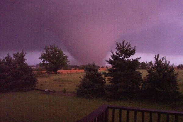
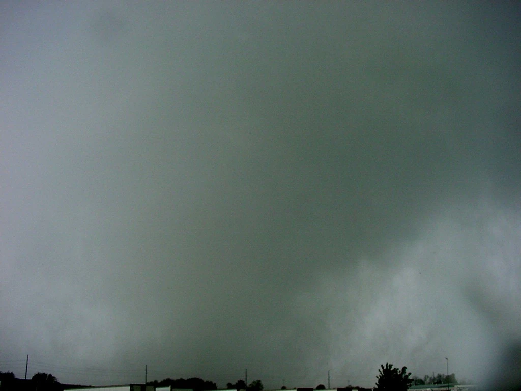
The tornado outbreak of January 1-2, 2025 was the largest tornado outbreak in the month of January on record. Very mild temperatures led to the cause of this event. All 185 tornadoes in this outbreak were produced by a powerful, long-tracked quasi-linear convective system (QLCS), moving through the Upper Midwest, Great Lakes, and Mid-Atlantic. Two EF4 tornadoes were spawned from this squall line. They occurred in Elma, Iowa and Goodfield, Illinois. 43 significant tornadoes touched down in this outbreak, with several of these causing numerous injuries and several fatalities. This outbreak was also one of the most destructive in history, and as well as becoming one of the costliest of the 2020s decade. Aside from tornadoes, violent wind damage occurred from this line of storms. Due to its development along a cold front, following the storms, a significant winter storm impacted tornado-stricken areas of the Upper Midwest, Ohio Valley, and Mid-Atlantic. The outbreak is memorable for being the only derecho in United States' history to occur in the winter, and as well as the most powerful derecho to impact the state of Illinois. Several tornadoes in the outbreak caused well over $500 million (2025 USD) in damages, and several significant tornadoes impacted large cities, such as Sioux Falls, Waterloo, Davenport, Springfield, Indianapolis, Cincinnati, Roanoke, and Raleigh. Overall, there were eleven fatalities and numerous injuries from this outbreak, making it one of the deadliest outbreaks in the month of January on record. Damages amounted to around $1.8 billion (2025 USD), due to the many significant tornadoes that impacted the Upper Midwest, Upper Mississippi Valley, the Great Lakes, Ohio Valley, and the Mid-Atlantic from January 1-2, 2025.
Synopsis[]
At the end of December 2024, a strong high-pressure area was situated over the Central United States and Southern Canada. The jet stream was situated over the United States/Canada border along Montana, North Dakota, and Minnesota, allowing for warm air to be trapped. Moisture from the Gulf of Mexico allowed for some high-rainfall events in the Southern United States and Ohio Valley, leading to a record wet Christmas for some. Record highs across the Central United States and Mid-Atlantic were being shattered from December 23 - January 1. Bismarck, North Dakota reached a January record high of 69°F (20.5°C) on January 1. Indianapolis (81°F), Des Moines (73°F), and Cincinnati (84°F), were among other places to reach record highs from this abnormal January heatwave.
On December 31, a cold front swept down from Alberta, with temperatures of -10°F at its tail end. The Storm Prediction Center (SPC) issued a slight risk for Central North Dakota, Extreme Northeast South Dakota, and West Central Minnesota for damaging winds at the 1730Z Day 2 outlook. Behind this cold front, snowfall of up to one foot was being recorded, with totals of up to two feet in higher elevations.

1730Z D2 Outlook - Valid January 1, 2025
On the morning of January 1, record highs were being smashed, as mentioned earlier, before this cold front swept through. At 3:00 pm MST, the cold front entered Montana through Saskatchewan. With the supply of dew points around 65°F, storms began to fire along the edge of the front, producing damaging winds as it made its way through Montana and North Dakota. As many squall lines do, this line of storms began to produce spin-up tornadoes in North Dakota, with the first being a weak tornado in McKenzie County. At 5:00 pm CST, the Storm Prediction Center (SPC) issued a particularly dangerous situation (PDS) tornado watch, for Central North Dakota, Northeast South Dakota, and Central Minnesota, lasting through the night. The SPC noted that the potential for brief but intense tornadoes was very high, which eventually verified as the line of storms moved across North Dakota. An EF3 tornado touched down in the Steele area, causing major damage to a farm outside of that town.
The first deadly tornado of the outbreak struck Valley City, North Dakota, where high-end EF2 damage was observed. The line of storms continued through North Dakota, eventually producing another deadly tornado in White Rock, South Dakota, destroying all buildings in the town, causing one fatality and wiping the three-resident town off the map. At 2000z, the SPC upgraded the slight risk for tornadoes, hail, and damaging winds to a moderate risk. They also upgraded the Day 2 enhanced risk for Iowa, Illinois, Indiana, and Ohio to a high risk for damaging winds and tornadoes. As this line moved across Minnesota, relatively weak tornadoes touched down, and wind gusts of 80-90 mph were being recorded, with isolated gusts of 100-110 mph. A strong, EF3 tornado touched down in Lincoln County, Minnesota, tearing through the town of Minneota around 7:00 pm (CST). A wind gust of 114 mph was recorded in Albert Lea, Minnesota, where trees and power poles were snapped and where mobile homes were destroyed.

Day 2 high risk outlook - Valid January 2, 2025
As this squall line began to reach peak intensity in Minnesota, it crossed into Iowa, producing violent tornadoes and persisting damaging winds. The Storm Prediction Center issued another particularly dangerous situation (PDS) tornado watch, including Iowa, Southern Wisconsin, Illinois, and Central Indiana. An EF4 tornado touched down in Elma, Iowa, wiping out a mobile home and leveling a brick farmhouse. Almost simultaneously, an EF3 tornado touched down in Waterloo, Iowa, moving through downtown, causing major damage and numerous injuries. The squall line kept its intensity as it moved through Southeast Iowa, producing wind gusts of 80-90 mph still. A wind gust of 99 mph was recorded in Cedar Rapids, and a 97 mph wind gust was recorded in Tipton. The line moved through Davenport around midnight, where a large tornado touched down, moving through East Moline, Illinois, causing three fatalities.
Across North Central Illinois, violent tornadoes were touching down and causing extraordinary damage. An EF3 tornado touched down north of Galesburg, moving across I-74, where a well-built home had mostly collapsed. As the tornado moved through the Peoria region, the squall line produced the most intense tornado of the outbreak. An EF4 tornado touched down near Goodfield, leveling and partially sweeping away well-built homes on the north side of town, causing one fatality. This same storm eventually produced an EF1 tornado on the north side of Bloomington, just minutes later. With the line now beginning to move through Indiana around 4:00 am CST, winds of 70-80 mph were being recorded along the front. An EF2 tornado touched down on the north side of Indianapolis, causing five injuries and damaging 30 homes. An EF3 tornado touched down in Brown County State Park, debarking trees. Had the tornado hit structures, it would have been likely an EF4, according to the National Weather Service Office in Indianapolis.
One of the most impressive tornadoes produced by the squall line struck the city of New Castle, causing four fatalities as the tornado moved through the city around 6:00 am EST. The line, now moving through Ohio, began to produce rather weak tornadoes; however, an EF2 tornado touched down in Hillsboro, causing many injuries. High winds were recorded throughout Southern and Central Ohio, with gusts up to 85 mph being recorded. The top wind gust recorded from the line in Ohio was 84 mph at Sharonville. Now weakening, the line began to move through West Virginia around 10:00 am EST, with wind gusts of 60-70 mph. Many weak tornadoes touched down throughout West Virginia, including an EF1 tornado that caused 17 injuries in Beckley. The line entered Virginia around noon, briefly restrengthening as it quickly moved through. The last significant tornado produced by the line occurred in Danville, where three fatalities occurred and multiple homes were destroyed.
Weakening yet again, the squall line moved through North Carolina, producing multiple weak tornadoes. A wind gust of 61 mph was recorded in Raleigh, along with an EF1 tornado that damaged several homes. As the squall line was moving through North Carolina, supercells developed across South Carolina and Southern Georgia, producing several weak tornadoes before finally dissipating around 10:00 pm EST.
Behind the cold front, a major winter storm occurred, blanketing most of the Upper Mississippi Valley, Ohio Valley, and Mid-Atlantic in more than six inches of snow. Ice preceded the snowfall, glazing many of the tornado-stricken areas before receiving considerable amounts of snowfall. Blizzard conditions were reported throughout the Upper Midwest, as well. Outside of the system, a major flooding event occurred in Texas and Louisiana, causing multiple river gauges to surpass major flooding stage by January 3.
Notable Tornadoes[]
Valley City, North Dakota[]
| EF2 tornado | |||
|---|---|---|---|
| |||
| Duration | 5:59 pm – 6:07 pm (CST) | ||
| Intensity | 215 km/h (135 mph) (1-min) | ||


The line that produced this tornado produced two other tornadoes before this one, including a significant tornado in Spiritwood, and a weaker tornado near Sanborn. 80 mph winds were being recorded by this storm, which prompted the National Weather Service Office in Grand Forks to issue a severe thunderstorm warning. This warning was considered a "very dangerous situation" and noted the hazard of a possible brief tornado, as common with lines such as the one moving across North Dakota at this time. Around 6:56 pm CST, a funnel was noted near the Sanborn area, from a previous tornado that had lifted moments earlier. Law enforcement first reported the touchdown of a rope tornado at 6:59 local time, north of Berea, moving southeast at 65 mph. Moments after touching down, a farm was struck by the tornado, causing major damage to outbuildings. The tornado rapidly widened into a stovepipe tornado just moments later, then to a large, wedge tornado soon after. The tornado reached a peak width of 1,105 yards (0.62 mi), just three minutes after touchdown, outside of Valley City. At this time, the National Weather Service Office in Grand Forks issued a "particularly dangerous situation" (PDS) tornado warning for the Valley City area. Three well-built homes were heavily damaged on 115th Avenue, with two that had their roofs entirely torn off. A detached garage on one of these homes was flattened, signifying EF1-2 damage. Trees were snapped or uprooted along 33rd Street, where a mobile home was rolled on its side. A junkyard, next door, had multiple cars rolled and tossed short distances, and two garages were destroyed. The tornado then moved directly into Valley City, after crossing 9th Avenue. Several well-built homes sustained extensive damage along 9th Street, where power lines and poles were downed. One line fell into a home at this location, falling through an interior bathroom, where a woman was sheltering, causing one fatality. At 7:04, the tornado had begun to move through the north side of the city, around 800 yards (0.45 mi) wide, producing widespread EF1-EF2 damage. Numerous trees were snapped, uprooted, or damaged as the tornado crossed Central, 2nd, 3rd, 4th, and 5th avenues on the north side of town. The Barnes County Courthouse received minor damage from the tornado as it made its way across the town. A church sustained heavy roof damage on 5th Street, and a large garage was destroyed on 12th Avenue. Crossing main street, several garages sustained heavy damage and multiple trees were uprooted. A few homes sustained extensive roof, siding, and gutter damage. The tornado began to rope out, crossing I-94, moving into an open field. Limbs were torn off trees before the tornado lifted at 7:07 pm CST, just before crossing 20th Avenue. Overall, one fatality was reported, along with eleven injuries, from the first fatal tornado of the outbreak.
Elma, Iowa[]
| EF4 tornado | |||
|---|---|---|---|
| |||
| Duration | 11:03 pm – 11:08 pm (CST) | ||
| Intensity | 270 km/h (170 mph) (1-min) | ||


As the squall line began to move through the state of Iowa, it was reaching its peak intensity, with wind gusts of up to 100 mph. At 10:57 pm CST, the National Weather Service Office in La Crosse, Wisconsin issued a particularly dangerous situation severe thunderstorm warning for Eastern Mitchell County, Western Howard County, Northeast Floyd County, and Northern Chickasaw County, Iowa, for wind gusts of up to 100 mph, noting the possibility of a weak tornado. As the line moved to the southeast at 65 mph, a funnel cloud was noted south of Riceville. At this time, the National Weather Service Office in La Crosse issued a tornado warning, for the possibility of a tornado near Elma. At 11:03 pm CST, a rain-wrapped, cone tornado touched down to the northwest of Elma, rapidly moving southeast. The tornado crossed Elm Avenue, striking a farm. At this particular farm, the roof of a home was torn off, and four barns were flattened. The tornado rapidly intensified, scouring the ground as it crossed 190th street, where a poorly-anchored farm was swept away, signifying high-end EF3 damage. A large barn at this location was swept away as well, and two grain silos were flattened. Just behind this location, a well-built home was leveled, and barns at this location were flattened as well. Ground scouring continued as the tornado moved south of Elma, debarking, snapping, or uprooting many trees. The tornado weakened as it approached Garden Avenue, uprooting numerous trees and damaging a barn. EF0 damage was noted at a home off Garden Avenue north of Alta Vista as the tornado began to rope out. The tornado briefly crossed into Chickasaw County before lifting just to the north of Alta Vista. Miraculously, there were no injuries or fatalities caused by this tornado.
Waterloo, Iowa[]
| EF3 tornado (NWS) | |||
|---|---|---|---|
| |||
| Duration | 11:05 pm – 11:11 pm (CST) | ||
| Intensity | 220 km/h (140 mph) (1-min) | ||

As a violent tornado was shredding homes near Elma, a particularly dangerous situation (PDS) severe thunderstorm warning was issued by the National Weather Service Office in Des Moines for Central Black Hawk County, with the possibility of a tornado. At 11:04 pm, a funnel cloud was noted over the city of Cedar Falls, moving southeast at 60 mph. At 11:05 pm, a cone tornado touched down along I-380 in Northern Waterloo, moving to the southeast. The National Weather Service Office in Des Moines issued a tornado emergency for the city of Waterloo at this time. The tornado struck the McElroy Auditorium, causing minor damage to the roof of the structure. At this location, outbuildings were heavily damaged and cars were overturned. A few retail buildings sustained extensive damage to their roofs, as well as having windows blown out of the buildings. Now widening, the tornado rapidly intensified and destroyed a warehouse building along I-380. The tornado then crossed I-380 at Elks Memorial Park, into downtown Waterloo. Multiple trees were snapped along Randolph Street, and many homes were either damaged or destroyed. Non-bearing walls at the Emerson School were collapsed, signifying EF3 damage to the school. Houses around the school sustained high-end EF2 damage. The roof of a dentist office was torn off, and two churches sustained extensive damage to their roofs. An auto repair shop had all of its exterior walls blown in, and homes around it were unroofed. Some trees were debarked along South Street, and a Wesleyan Church sustained extensive damage. Now weakening, the tornado struck Lowell Elementary School, removing sections of roofing. Many trees were uprooted or damaged as the tornado moved through southeast Waterloo. The tornado restrengthened, striking a bowling alley, which sustained EF2 damage. A Pizza Hut lost its roof on La Porte Road, and the awning of a gas station was blown over. An auto parts building received minor damage on Sheffield Avenue. The last trace of tornado damage was noted along Easton Avenue, where tree limbs were snapped off trees. Overall, this tornado led to 78 injuries, but miraculously, no fatalities occurred from this tornado.
East Moline-Colona, Illinois[]
| EF2 tornado (NWS) | |||
|---|---|---|---|
| |||
| Duration | 12:03 am – 12:12 am (CST) | ||
| Intensity | 185 km/h (115 mph) (1-min) | ||


As the squall line was closing in on the Quad Cities, winds of 90-100 mph were being recorded, causing extraordinary straight-line wind damage, along with weak tornadoes; however, as the tornado entered the northern side of Davenport, rotation on the storm began to tighten, and a wall cloud was observed over the Davenport Municipal Airport at 11:58 pm (CST). This then produced a funnel cloud, along with a brief, EF1 tornado, that touched down on the north side of Davenport at 12:00 am (CST), damaging several buildings along East 53rd Street. After this tornado lifted, a persistent funnel cloud was observed over East Kimberly Road in Davenport. At 12:02 am, the National Weather Service issued a tornado emergency for Davenport, Moline, and East Moline. Soon after, the aforementioned funnel cloud touched down over the Premier Brick and Stone Company, causing minor roof damage to the building. The tornado then crossed the Mississippi River, where it entered the city of East Moline. The tornado destroyed buildings along the river, which had already been previously damaged after a major flood from November 29 - December 6, as a result of a major winter storm that struck the region. Along 15th and 16th Avenue, homes were unroofed, trees were uprooted, and garages were destroyed, causing two injuries in this area. The tornado then struck Hillcrest Elementary School, where exterior doors were blown in and sections of roofing were torn off, signifying low-end EF2 damage, due to the high construction quality of the building. A poorly-built home on 5th Street was shifted off its foundation, where two injuries and one fatality occurred. The tornado briefly entered a wooded area before striking many more buildings on the eastern side of the city, where outbuildings at a church were flattened. The tornado then struck the Short Hills Country Club, where trees were uprooted and outbuildings were damaged or destroyed. The tornado then crossed 1st Street, where many homes were unroofed or sustained heavy roof damage. An animal clinic on 30th Avenue had its windows blown in, and gutters on the building were torn off. Similar damage occurred at a 7-Eleven, just across the street. A home that had just started construction on 1st Street was hit as well, causing its collapse. The tornado, now roping out, barely missed the Illini Hospital, causing light damage to trees behind the facility. The tornado then restrengthened, passing through the southern half of Silvis, causing major roof damage yet again to homes. A Walmart Supercenter was struck, causing heavy damage to the building. Just before crossing Colona Road, the tornado struck many homes on the south edge of Carbon Cliff. A church sustained light roof and siding damage in this area, and a outbuilding on the same property was destroyed. Trees at a golf course near this location had limbs torn off. Now restrengthening for a third, and final time, the tornado crossed into Henry County, where trees were snapped or uprooted. The tornado maintained EF1 intensity as it moved through the south side of Colona, causing relatively light damage to homes, while downing, snapping, or uprooting trees through this region. Power poles and lines were also damaged, leading to major power outages in the city. The most intense damage in Colona was observed at the Colona Public Library, where large sections of the roof were torn off, windows were blown in, and gutters were torn off. Mobile homes at the edge of Colona sustained significant damage before the tornado moved out of town. The tornado tore limbs off trees before lifting just to the southeast of Colona. Overall, very significant damage was recorded from this tornado, along with one fatality and multiple injuries. The tornado became the strongest to affect Rock Island County, Illinois since March 13, 1990, 35 years prior.
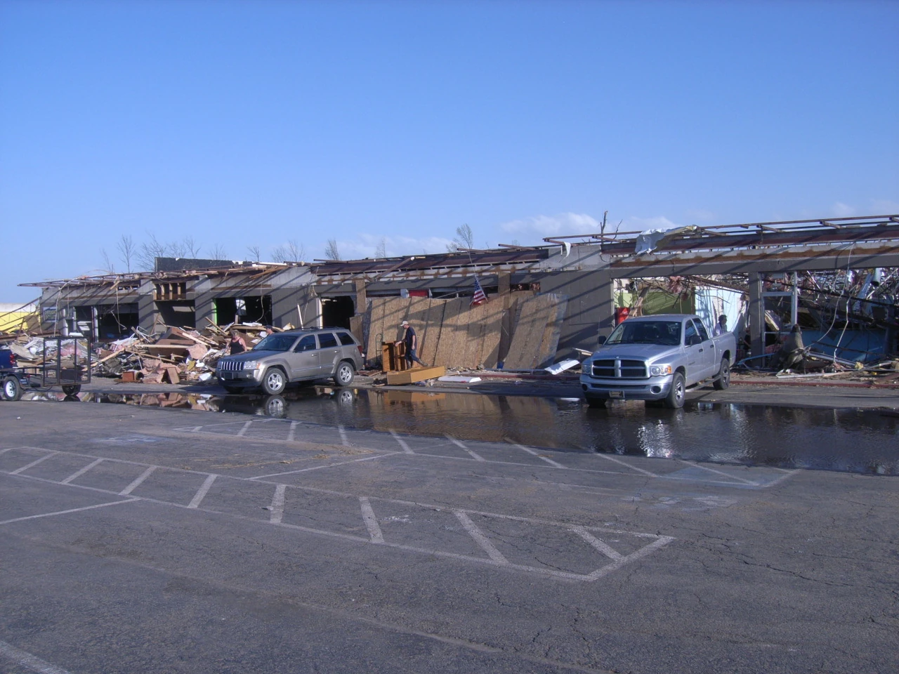
Goodfield-Congerville, Illinois[]
| EF4 tornado (NWS) | |||
|---|---|---|---|
| |||
| Duration | 1:20 am – 1:27 am (CST) | ||
| Intensity | 285 km/h (180 mph) (1-min) | ||
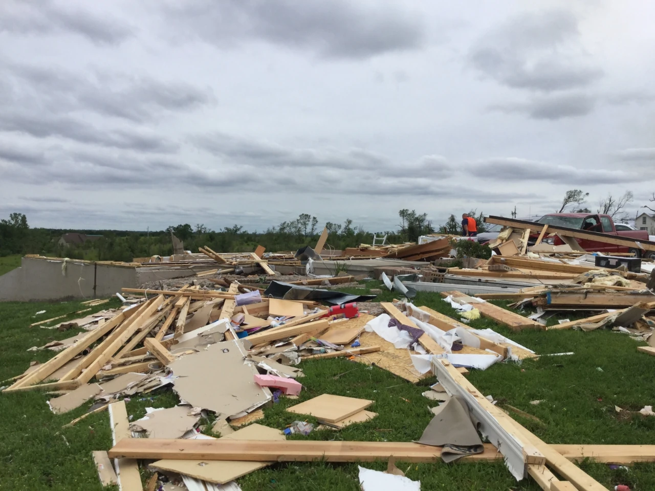
As this powerful squall line, now considered a derecho, tore across Central Illinois, many significant tornadoes were touching down, including a powerful EF2 tornado that struck the Davenport metro just an hour before. At 1:00 am CST, the National Weather Service Office in Lincoln, Illinois issued a tornado warning for Southeast Peoria County, Northern Tazewell County, Western Woodford County, and Western McLean County, Illinois until 1:35 am CST. This line was moving east-southeast at 70 mph at this exact moment, as the line tore through the Peoria region. From this warning, an EF0 tornado touched down in downtown Peoria, causing minor damage to buildings. A second tornado touched down as well, rated EF2, south of Washington, tearing the roof off a well-built home. At 1:19 am CST, a funnel cloud was noted yet again from this same storm, reported by law enforcement, located along Dee-Mac Road, northwest of Deer Creek. This funnel then crossed into Woodford County, where it proceeded to touch down in an open field between County Road 1125 East and County Road 1200 East, northeast of Deer Creek, moving east-southeast of 70 mph. Old farm equipment near this location was tossed, and a barn was destroyed. A farmhouse had shingles blown off its roof, and windows were blown in on the house. Siding and gutters were also torn off in spots. The tornado rapidly intensified over an open field north of the town of Goodfield, where ground scouring was first noted. The tornado grew to an impressive size, around 1625 yards (0.92 mi), and moved through the north side of Goodfield, damaging or destroying 30% of buildings in the city. A garage north of Goodfield, along State Highway 117, was leveled and swept away, signifying EF3 damage. The roof of the Trinity Stone Center was blown off, and similar damage occurred to homes along W Belaire Ct, where EF1-EF2 damage was noted. The most significant damage occurred along Parkside Drive and Scenic Drive, where multiple, well-built, well-anchored homes were leveled. Trees at this location were entirely denuded. A truck at this location was thrown 250 yards, and an above-ground pool was tossed 150 yards away from its origin. A well-anchored, new home was given an EF4 damage indicator after it was leveled and partially swept away. The tornado passed through Goodfield Park, producing high-end EF3 damage after debarking multiple trees. The tornado then passed through Maple Drive, where two homes were almost leveled, but leaving some interior walls. The tornado began to weaken as it left Goodfield, snapping or uprooting numerous trees. Three homes were unroofed and several outbuildings were flattened along U.S. 150. One fatality occurred when a tree fell on a woman's home on County Road 1550 East. The tornado then entered a mostly wooded area before making a direct hit on the town of Congerville, where widespread, low-end EF1 damage was noted. Many trees were uprooted throughout town, and outbuildings were either heavily damaged or destroyed. A home along Reaba Avenue had its roof torn off, and other homes throughout town sustained relatively light damage. Many homes had gutters ripped off, shingles blown off, or vinyl siding peeled off the side of homes. Limbs were torn off trees in downtown Congerville, where very light damage was reported to buildings. The tornado finally lifted on the eastern edge of Congerville. This tornado was the strongest of the entire outbreak. Overall, this violent tornado caused one fatality and thirteen injuries.
New Castle, Indiana[]
| EF3 tornado (NWS) | |||
|---|---|---|---|
| |||
| Duration | 5:36 am – 5:40 am (EST) | ||
| Intensity | 270 km/h (165 mph) (1-min) | ||

The squall line, now slightly weakening, had entered its way through Indiana by 3:00 am, changing direction from east-southeast to southeast. Around 5:00 am, the line was nearing the Indiana/Ohio state line, with several embedded supercells. One of these prompted the National Weather Service Office in Indianapolis to issue a tornado warning for Central and Eastern Henry County, until 6:00 am EST. This storm was reported to have caused two tornadoes prior to entering Henry County, which included an EF1 on the east side of Anderson and a weak, EF0 tornado west of Middletown, which heavily damaged two barns. A lowering was first noted with a wall cloud at 5:33 am, near Sulphur Springs, along US 36, which was reported by law enforcement. About a minute later, a funnel was first sited, now to the south of Sulphur Springs, moving southeast at 75 mph. This quick-moving, intense, rotating funnel touched down, just as it was entering the city of New Castle, along State Road 38 west of town. At this time, the National Weather Service in Indianapolis issued a rare tornado emergency for the city of New Castle. A stainless steel company sustained significant roof damage, noting that the tornado caused EF1 damage almost immediately upon touchdown. Next door, outbuildings at a lumber company were flattened or heavily damaged. The tornado then moved through a wooded area, snapping or uprooting many trees before moving into an open field. Then, the tornado was noted to have debarked trees just as it was entering the business district in New Castle. The New Castle Plaza took a direct hit from the tornado, which sustained major damage. The building was almost leveled, signifying high-end EF3 damage. Multiple restaurants at this location sustained significant damage as well, including a Long John Silver's, a Pizza King, and a Stack's Pancake House. The roof of a bank was torn off on South Memorial Drive, and a Pizza Hut had its windows blown in, along with sections of roofing torn off. The New Castle Community Schools Corporation building was struck on Elliott Avenue, which lost all of its exterior walls. Homes at this location sustained significant to major damage, including one home that was leveled, but was not built to standard, signifying 150 mph EF3 damage. The tornado then briefly moved into a heavily wooded area of New Castle, where numerous trees were debarked or denuded. Several homes in this area were leveled, and were given a high-end, 165 mph EF3 rating. The tornado then entered a cemetery, where several trees were snapped at the base, and a historic home lost its roof. An outbuilding at this location was swept away as well. The tornado grew to 450 yards at peak, just north of Parker Elementary School, which sustained light roof damage. Many homes in this area were unroofed or sustained damage to exterior features. The tornado then heavily damaged or destroyed multiple old, poorly-built homes as it was beginning to cross I Avenue. The tornado, now weakening, struck the Crown Equipment USA building, tearing off major sections of the roof, blowing in windows, and causing serious damage to exterior walls. The tornado uprooted a few more trees before briefly moving into an open field, yet again. The tornado flattened a garage on Hunter Avenue, and partially tore the roof off a house. About five mobile homes in this area were destroyed, and one was rolled onto its side, signifying EF1 damage. One fatality occurred at this location. The tin roof of a large building was peeled off in sections, and limbs were torn off trees at this point. The tornado then crossed South County Road 250 East, causing very minor damage to a home. The tornado, now in its final seconds, crossed East County Road 200 South, tearing the roof off a barn, before lifting in the woods behind the residence that this barn sat at. Overall, four fatalities were caused by this tornado, and numerous injuries were reported. Causing $1.3 billion (2025 USD) alone, this tornado became the costliest tornado in Indiana's history, as well as becoming the 6th costliest tornado in history, taking the place of the 2011 Hackleburg–Phil Campbell tornado.
Danville, Virginia[]
| EF3 tornado (NWS) | |||
|---|---|---|---|
| |||
| Duration | 1:11 pm – 1:15 pm (EST) | ||
| Intensity | 240 km/h (150 mph) (1-min) | ||

The squall line, now restrengthening for a brief amount of time in Virginia, had begun to produce a slew of significant tornadoes during January 2, in the middle of the day. One of these was produced by an embedded supercell in Altavista, which was rated EF2, after destroying garages, barns, and other outbuildings. Around this same time, a tornado warning was issued by the National Weather Service Office in Blacksburg, Virginia for Southern Pittsylvania County, Danville, Northern Caswell County, North Carolina, and Extreme Northeastern Rockingham County. A rain-wrapped funnel cloud was first spotted at about 1:00 pm, in Pittsylvania County, about six miles to the south-southwest of Callands, reported by law enforcement along Virginia Highway 57, moving southeast at 55 mph. This funnel cloud moved across the county, first producing an EF0 tornado, which struck areas near Hinesville around 1:05 pm, prompting a tornado emergency for the cities of Fairfield Park and Danville, until 1:30 pm EST. The original funnel that produced the EF0 near Hinesville lifted, but an impressive wall cloud was left behind. At around 1:08 pm, a funnel was noted yet again by law enforcement, which were located near the Sharon area, allowing the tornado emergency to continue. The funnel passed over the Mount Cross area as well, just before entering the Danville area, which it did at 1:10 pm EST. At 1:11 pm EST, the tornado touched down in Danville, in a wooded area just off Piney Forest Road, tearing limbs off trees and shingles off homes. The tornado then exited the wooded area where it touched down, destroying two mobile homes and causing minor damage to an orthodontics office on Piney Forest Road. The I.W. Taylor Elementary School had shingles blown off, windows blown in, and gutters torn off. Another dentist's office had its roof torn off, signifying EF2 damage, and an auto loans place sustained minor damage. The tornado, still a weak, EF1 tornado, downed or uprooted many trees and blew shingles off a home on Lennox Court. Several trees were snapped at the base, signifying EF2 damage, and several homes on Rockford Pl were heavily damaged, losing their roofs. As the tornado crossed Arnett Boulevard, a Fas Mart gas station was leveled, causing one fatality, and a house lost its roof and most of its exterior walls. Along Wendell Scott Drive, power poles were snapped, causing power lines to fall dangerously close to the ground. Along 3rd Avenue, homes were unroofed, and a poorly-built home was destroyed. Several garages were swept away at this location as well, and trees were debarked. Contextual damage supported a high-end EF2 rating at this location, and an old, abandoned house was destroyed on Rice Street. This house was unanchored, and the interior of the house was not connected to the foundation, causing the house to sag into the ground lower in the ground prior to the house being struck by the tornado. As the tornado moved north of downtown Danville, the tornado weakened to EF1 intensity, downing or uprooting many trees and causing relatively light damage to homes in the area. Trees were uprooted at a cemetery near this location, just before the tornado briefly restrengthened and tore the roof off an apartment building along North Main Street. Now weakening yet again, the tornado overturned a gas station awning, and many trees were downed. Homes on Forestlawn Drive received minor damage before the tornado weakened to EF0 intensity, tearing limbs off trees and downing softwood trees. The tornado destroyed two mobile homes on Lynch Street, causing two more fatalities. The tornado then crossed U.S. 29, just before lifting on Halifax Road. Overall, it was Virginia's strongest tornado in almost a decade. It was one of Virginia's costliest tornadoes on record, causing $460 million (2025 USD) in damages. In the end, three fatalities occurred, and about forty injuries occurred. The same embedded cell that produced this tornado went on to produce a high-end EF1 tornado in Southern Roxboro, North Carolina.
Confirmed tornadoes[]
| Confirmed Total |
Confirmed EF0 |
Confirmed EF1 |
Confirmed EF2 |
Confirmed EF3 |
Confirmed EF4 |
Confirmed EF5 |
| 185 | 86 | 56 | 31 | 10 | 2 | 0 |
January 1 event[]
| EF# | Location | County / Parish | State | Time (UTC) | Path length | Max width | Summary |
|---|---|---|---|---|---|---|---|
| EF0 | N of Mandaree | McKenzie | ND | 22:31–22:32 | 0.69 miles | 50 yd | A brief tornado destroyed several trailers and caused minimal damage to homes. |
| EF0 | Dunn Center | Dunn | ND | 22:39–22:41 | 1.2 miles | 55 yd | A brief tornado touched down in Dunn Center, damaging six homes and destroying around 25 trailers, causing two injuries. |
| EF1 | NW of Hazen | Mercer | ND | 22:58–23:02 | 3.19 miles | 350 yd | A rain-wrapped tornado destroyed an old barn and damaged several homes. |
| EF0 | SE of Beulah | Oliver | ND | 22:59–23:01 | 2.66 miles | 30 yd | A small tornado struck rural areas, causing minor tree damage. |
| EF2 | Center | Oliver | ND | 23:05–23:12 | 6.99 miles | 675 yd | A rain-wrapped, stovepipe tornado struck the town of Center, causing major damage within the town. Around 30 homes were either damaged or destroyed, and multiple trailers on the south side of town were destroyed. The Oliver County Courthouse was severely damaged, along with other downtown buildings. An abandoned low-rise building in the downtown area had its top story almost entirely destroyed. This tornado caused seven injuries. |
| EF0 | WNW of Harmon | Morton | ND | 23:07–23:12 | 5.29 miles | 50 yd | This tornado remained mainly over open fields. A farm was struck, where a barn had its tin roof peeled off. |
| EF0 | Northern Bismarck | Burleigh | ND | 23:13–23:14 | 0.17 miles | 25 yd | This very brief, weak tornado touched down in Northern Bismarck, damaging five homes. |
| EF1 | SE of Moffit | Burleigh | ND | 23:24–23:26 | 1.5 miles | 850 yd | Several outbuildings were destroyed, and one home had large sections of roofing torn off. |
| EF3 | Steele to S of Dawson | Kidder | ND | 23:25–23:34 | 8.88 miles | 1320 yd | A large tornado touched down in the city of Steele, causing light damage to many buildings on the north side of town. Soon after the tornado moved outside of Steele, it rapidly intensified and leveled a poorly-built farmhouse. Trees around this home were debarked, and outbuildings were obliterated. Light ground scouring was noted at this location, which continued as the tornado moved to the east-southeast. The tornado began to lose strength as it moved over open fields before eventually lifting near Dawson. |
| EF1 | NNE of Buchanan | Stutsman | ND | 23:39–23:45 | 6.32 miles | 207 yd | This tornado destroyed outbuildings and remained over open land for most of its life. |
| EF0 | Homer | Stutsman | ND | 23:40–23:42 | 1.27 miles | 65 yd | Limbs broke off trees and homes received light damage. |
| EF2 | Spiritwood | Stutsman, Barnes | ND | 23:45–23:51 | 5.84 miles | 685 yd | A large tornado blew through the town of Spiritwood, damaging or destroying many homes. Four people were injured. |
| EF0 | NE of Wimbledon | Barnes | ND | 23:52–23:53 | 0.73 miles | 50 yd | Little damage was observed from this tornado. |
| EF0 | NE of Eckelson to NE of Sanborn | Barnes | ND | 23:54–23:58 | 3.47 miles | 75 yd | An old barn was destroyed, and one home received minor damage. |
| EF2 | NNE of Berea to ESE of Valley City | Barnes | ND | 23:59–00:07 | 7.49 miles | 1105 yd | 1 death – See section on this tornado. A large tornado tore through Valley City around sunset. |
| EF0 | NE of Lamoure | Lamoure | ND | 00:00–00:03 | 2.58 miles | 40 yd | Limbs were torn off trees and a barn had sections of roofing torn off. |
| EF0 | WSW of Enderlin | Ransom | ND | 00:04–00:05 | 0.48 miles | No damage was observed from this tornado. | |
| EF0 | WSW of Gwinner | Sargent | ND | 00:08–00:08 | 0.23 miles | 25 yd | A barn received minor damage. |
| EF1 | WNW of Mantador | Richland | ND | 00:10–00:14 | 3.73 miles | 465 yd | An old barn was leveled, and a few trees were uprooted. |
| EF0 | N of Claire City | Roberts | SD | 00:15–00:17 | 1.06 miles | 90 yd | Some limbs were snapped off trees. |
| EF1 | Hankinson | Richland | ND | 00:20–00:22 | 1.17 miles | 83 yd | Trees were uprooted within the limits of the city of Hankinson, and many homes received light damage. |
| EF2 | SE of La Mars, ND to White Rock, SD | Richland (ND), Roberts (SD), Traverse (MN) | ND, SD, MN | 00:25–00:31 | 5.14 miles | 530 yd | 1 death – A large tornado touched down in rural areas of extreme southeast North Dakota, uprooting trees at the ND/SD border. All structures in the town of White Rock were damaged beyond repair, causing one fatality and wiping the town off the map. The tornado crossed into Minnesota, damaging a barn before lifting. |
| EF0 | Wahpeton, ND to Breckenridge, MN | Richland (ND), Wilkin (MN) | ND, MN | 00:25–00:26 | 0.35 miles | 50 yd | Trees were damaged before this tornado crossed the state line, entering a trailer park on the southern edge of Breckenridge, destroying multiple mobile homes and snapping limbs off trees before lifting. |
| EF0 | S of Milbank | Grant | SD | 00:26–00:29 | 2.8 miles | 90 yd | Several outbuildings were damaged. |
| EF0 | NE of Wheaton | Traverse | MN | 00:32–00:33 | 1.2 miles | 450 yd | A barn received major damage and several trees had limbs ripped off. |
| EF0 | W of Carlisle | Otter Tail | MN | 00:34–00:35 | 0.24 miles | 35 yd | A small barn was damaged and trees were snapped and uprooted. |
| EF2 | NNW of Dawson | Lac Qui Parle | MN | 00:48–00:53 | 4.16 miles | 460 yd | A tornado cut through the west side of Dawson, unroofing homes, uprooting trees, and downing power lines. Four people were injured. |
| EF0 | SW of Montevideo | Lac Qui Parle, Yellow Medicine | MN | 00:49–00:52 | 2.6 miles | 135 yd | Several homes sustained minor roof, siding, and gutter damage. Several outbuildings were heavily damaged, and some trees were uprooted. |
| EF2 | N of Gluek to NW of Clara City | Chippewa | MN | 00:52–00:56 | 3.99 miles | 50 yd | A manufactured home was destroyed, along with several barns and a grain silo. Several trees were snapped or uprooted, and power lines were downed along 70th Avenue SE. |
| EF1 | Hazel Run | Yellow Medicine | MN | 00:56–01:00 | 3.33 miles | 260 yd | A large, but rather weak tornado struck the Hazel Run area, damaging nine homes and downing many trees. |
| EF3 | SE of Porter to Minneota to NNW of Ghent | Lincoln, Lyon | MN | 01:03–01:17 | 13.6 miles | 1451 yd | A destructive tornado touched down in rural Lincoln County, damaging some farms and downing many trees. The tornado, paralleling Minnesota Highway 68, crossed into Lyon County, flattening a barn and tearing the roof off a house. Trees at this location were snapped or uprooted. The tornado moved directly into Taunton, where many homes were damaged or destroyed. Power lines were downed and poles were snapped. Several injuries occurred within the town of Taunton. Continuing to parallel Minnesota Highway 68, a well-built farmhouse lost all of its exterior walls, signifying EF3 damage. As the tornado entered Minneota, trees were debarked, light ground scouring was noted, and many homes were destroyed. 75% of buildings in the town of Minneota were damaged or destroyed. Now weakening, several outbuildings outside of town were flattened, and another home was unroofed before the tornado lifted near Ghent. This tornado was one of the longest-tracked of the outbreak. |
| EF0 | W of Hanley Falls to N of Cottonwood | Yellow Medicine | MN | 01:05–01:08 | 2.72 miles | 130 yd | A weak tornado remained over open fields for most of its life; however, three farms were damaged. |
| EF0 | NE of Wood Lake | Yellow Medicine | MN | 01:06–01:07 | No damage was reported. | ||
| EF0 | S of Cottonwood | Lyon | MN | 01:09–01:10 | 0.77 miles | 40 yd | A tree had its limbs torn off, and the roof was torn off a barn. |
| EF2 | Marshall | Lyon | MN | 01:18–01:20 | 1.18 miles | 505 yd | A poorly-anchored airport hangar was flattened. |
| EF1 | S of Delhi to SE of Redwood Falls | Redwood | MN | 01:18–01:26 | 10.36 miles | 215 yd | Several farms in rural Redwood County sustained extensive damage. The tornado struck Redwood Falls, snapping or uprooting many trees within the town, and causing light damage to homes. The tornado lifted southeast of town. The National Weather Service believes that this tornado could have been stronger, had it not remained over open fields for most of its life, before weakening and striking Redwood Falls. |
| EF0 | Heatwole | McLeod | MN | 01:19–01:21 | 3.9 miles | 20 yd | Minor damage was reported in Heatwole. |
| EF1 | S of Delano | Wright | MN | 01:20–01:21 | 1.74 miles | 60 yd | Multiple homes were damaged in residential areas south of town, trees were snapped, and recreational vehicles were flipped. |
| EF1 | NW of Lester Prairie to S of New Germany | McLeod, Carver | MN | 01:21–01:25 | 5.96 miles | 250 yd | A weak tornado barely missed the town of Lester Prairie; however, several farm buildings and sheds were damaged or destroyed. One home sustained minor damage while another had its windows blown out. Numerous trees were snapped or uprooted. A single-wide mobile home was nearly toppled, and several other trailers sustained minor damage. |
| EF1 | E of Franklin to SSE of Fairfax | Renville | MN | 01:24–01:29 | 6.75 miles | 450 yd | An old barn was leveled, and a home was unroofed. |
| EF0 | S of Dell Rapids | Minnehaha | SD | 01:25–01:27 | 1.94 miles | 340 yd | Many trees were downed or uprooted south of town, and several outbuildings had their roofs torn off. |
| EF0 | Southern Sioux Falls | Minnehaha, Lincoln | SD | 01:59–02:03 | 1.1 miles | 125 yd | Around 75 homes received light damage on the south side of Sioux Falls. Many trees were damaged or downed, and several businesses sustained light roof damage. Two people were injured from a downed tree on their home. |
| EF0 | NW of Holland | Pipestone | MN | 03:35–03:39 | 3.91 miles | 30 yd | Light damage was reported from this tornado. |
| EF0 | S of Balaton | Murray | MN | 03:41–03:45 | 2.64 miles | 250 yd | An old barn was unroofed. |
| EF0 | SSE of Tracy | Murray | MN | 03:43–03:44 | 0.66 miles | 25 yd | Little to no damage was reported from this weak tornado. |
| EF0 | WNW of Delft | Murray | MN | 03:59–04:03 | 2.34 miles | 250 yd | Trees were uprooted on a large farm west of Delft. Outbuildings at this location were heavily damaged, and a home at this location sustained extensive roof damage. |
| EF1 | North Mankato to Mankato | Nicollet, Blue Earth | MN | 04:00–04:06 | 5.71 miles | 170 yd | A tornado, accompanied by wind gusts of up to 100 mph, struck North Mankato around 10:00 pm CST, first causing extensive damage to a farm outside of town. A trailer park on the north side of town received significant damage. Multiple trailers were rolled onto their sides, or had their roofs and walls torn off. Numerous trees were snapped or uprooted, and a power pole on Haughton Avenue was snapped, causing power lines to fall to the ground. Numerous trees were downed in Bluff Park, and the roof of a home was torn off nearby. The tornado then hit the Mankato Brewery, causing extensive damage to the roof of the building. The tornado then weakened, crossing into Mankato, where numerous homes and businesses received light to moderate damage. |
| EF2 | SW of Good Thunder | Blue Earth | MN | 04:08–04:10 | 1.01 miles | 75 yd | A small, brief, but intense tornado leveled three barns near Good Thunder. |
| EF0 | N of Spirit Lake, IA | Jackson | MN | 04:11–04:16 | 6.29 miles | 40 yd | Light damage was reported from this tornado. |
| EF0 | Frost | Faribault | MN | 04:26–04:28 | 0.68 miles | 150 yd | Multiple trees were downed or uprooted, and an abandoned train station had sections of its roof torn off. Five outbuildings sustained significant damage. |
| EF1 | SSW of Rock Valley to W of Sioux Center | Sioux | IA | 04:27–04:34 | 6.89 miles | 75 yd | A barn was flattened, and two homes were unroofed. Several trees were snapped or uprooted. |
| EF0 | ENE of Manly to E of Plymouth | Worth, Cerro Gordo | IA | 04:27–04:32 | 5.95 miles | 150 yd | This tornado remained over open fields for most of its life. |
| EF0 | NE of Hampton | Franklin | IA | 04:28–04:30 | 1.25 miles | 200 yd | An old barn was unroofed. |
| EF0 | S of Greene | Butler | IA | 04:49–04:50 | 0.73 miles | 25 yd | Light damage was reported. |
| EF2 | Southern Waverly | Bremer | IA | 04:57–05:03 | 5.74 miles | 165 yd | A strong tornado struck the south side of Waverly, unroofing many homes, damaging businesses, and downing power lines throughout the town. 30 people were injured. |
| EF4 | WNW of Elma to N of Alta Vista | Howard, Chickasaw | IA | 05:03–05:08 | 4.52 miles | 275 yd | See section on this tornado. |
| EF0 | S of Janesville | Black Hawk | IA | 05:04–05:04 | 0.4 miles | 25 yd | Several homes sustained light roof damage, and several tees were downed. |
| EF3 | Waterloo | Black Hawk | IA | 05:05–05:11 | 4.74 miles | 580 yd | See section on this tornado. |
| EF0 | Melbourne | Marshall | IA | 05:07–05:11 | 4.7 miles | 100 yd | Multiple homes were damaged in Melbourne, and many trees in town were uprooted. |
| EF0 | WSW of Fayette | Fayette | IA | 05:09–05:12 | 3.13 miles | 25 yd | Light damage was reported. |
| EF0 | N of Sigourney | Keokuk | IA | 05:10–05:12 | 1.5 miles | 430 yd | Many homes sustained light roof damage, and several weak outbuildings were flattened. |
| EF0 | SSE of Homestead | Iowa | IA | 05:12–05:13 | 1.38 miles | A large, cone, rain-wrapped tornado was photographed and videoed by storm chasers; however, no damage was reported. | |
| EF3 | WNW of Prairieburg to WSW of Langworthy | Linn, Jones | IA | 05:13–05:23 | 10.51 miles | 750 yd | A poorly-built home was leveled and swept away. |
| EF1 | NNE of Farley | Dubuque | IA | 05:14–05:17 | 3.3 miles | 150 yd | Many trees were snapped or uprooted. |
| EF0 | N of Wyoming | Jones | IA | 05:20–05:22 | 1.62 miles | 65 yd | An old barn was flattened. |
| EF0 | WSW of Clarence | Cedar | IA | 05:26–05:28 | 2.36 miles | 85 yd | Shingles, gutters, and siding was torn off a home, and several trees were uprooted. |
| EF1 | Tipton | Cedar | IA | 05:27–05:28 | 0.9 miles | 100 yd | Several outbuildings were destroyed, homes were unroofed, and many trees throughout the south side of town were downed or uprooted. Two people were injured. |
| EF1 | NNW of West Liberty | Muscatine | IA | 05:29–05:31 | 3.15 miles | 80 yd | Several homes and grain bins were damaged, and trees were downed. |
| EF0 | S of New Liberty | Scott | IA | 05:39–05:40 | 0.84 miles | 75 yd | The tornado touched down just northwest of town and moved off to the east, damaging a small barn and causing roof damage to a house. Several trees were downed along the path. |
| EF1 | Walcott | Scott | IA | 05:56–05:58 | 1.81 miles | 115 yd | Approximately 15 homes and 1 business suffered damage. Trees were damaged as well. |
January 2 event[]
| EF# | Location | County / Parish | State | Time (UTC) | Path length | Max width | Summary |
|---|---|---|---|---|---|---|---|
| EF1 | Northern Davenport | Scott | IA | 06:00–06:01 | 0.75 miles | 50 yd | A gas station awning was toppled, windows of a restaurant were blown in, and large sections of the roof at the Clarion Hotel was partially torn off. Similar damage occurred at a Burger King, where sections of roofing was torn off. A few trees along the path were either snapped or uprooted. |
| EF0 | W of Comanche | Clinton, Rock Island (IL) | IA, IL | 06:01–06:04 | 3.38 miles | 240 yd | Trees were damaged, and a home was damaged as well. |
| EF2 | Davenport to East Moline, IL to Colona, IL | Scott, Rock Island (IL), Henry (IL) | IA, IL | 06:03–06:12 | 8.2 miles | 550 yd | 1 death – See section on this tornado. |
| EF0 | WSW of Gratiot | Lafayette | WI | 06:05–06:07 | 2.67 miles | 85 yd | The roof of a barn was ripped off, and a carport and sheds were damaged. |
| EF0 | ENE of Ustick | Whiteside | IL | 06:10–06:11 | 1.21 miles | 40 yd | Trees were downed along the path of this tornado. |
| EF0 | SW of Morrison | Whiteside | IL | 06:11–06:12 | 2.05 miles | 60 yd | Several trees were uprooted or snapped, and a few buildings/sheds sustained minor roofing damage. |
| EF0 | SW of Eliza | Mercer | IL | 06:13–06:14 | 1.71 miles | 95 yd | Brief touchdown in a rural area. Eyewitness reports indicate that there was visible debris when the tornado was on the ground. Minor tree damage was reported. |
| EF1 | S of Illinois City | Rock Island | IL | 06:13–06:14 | 0.4 miles | 90 yd | A mobile home was destroyed and a permanent home sustained roof damage. Trees were snapped and uprooted as well. |
| EF0 | SSE of Illinois City to N of Buffalo Prairie | Rock Island | IL | 06:14–06:17 | 2.16 miles | 180 yd | Continuation of previous tornado, which briefly lifted. A house and a barn sustained minor roof damage, and many trees were snapped. |
| EF0 | S of Forreston | Ogle | IL | 06:15–06:17 | 1.64 miles | 175 yd | Trees, roof shingles, and a metal shed were damaged. |
| EF2 | E of German Valley | Stephenson | IL | 06:15–06:18 | 1.82 miles | 105 yd | Multiple homes damaged, including one that lost portions of its roof. Trees were damaged and 12 power poles were snapped as well. |
| EF0 | SE of Polo | Ogle | IL | 06:16–06:17 | 1.46 miles | 35 yd | Brief tornado flipped a shed and downed trees and power lines. |
| EF3 | Rock Falls | Whiteside, Lee | IL | 06:17–06:24 | 6.57 miles | 460 yd | Several homes were left with only interior rooms standing, the athletic fields at the local high school sustained major damage, and a water tower was punctured by flying debris, resulting in a major water leak. Numerous trees and power poles were snapped along the path, and pivot irrigation systems were flipped and twisted. Outbuildings at the local airport were swept away, as well. Seven people were injured, with two of those being critical. |
| EF2 | N of Cambridge | Henry | IL | 06:17–06:22 | 5.68 miles | 160 yd | Several outbuildings and two mobile homes were destroyed. A few homes sustained roof and siding damage and outbuildings were destroyed. A few trees were snapped or uprooted along most of the track. A tower structure was damaged towards the end of the path. |
| EF3 | N of Galesburg | Knox | IL | 06:19–06:25 | 6.18 miles | 1050 yd | Tornado caused major damage near Galesburg, where several homes, mobile homes, and outbuildings were damaged or destroyed, and many trees were snapped. Multiple vehicles were tossed or flipped as well. A well-built home had mostly collapsed, and trees off I-74 were debarked. |
| EF1 | NE of Berwick to SW of Abingdon | Warren, Knox | IL | 06:21–06:25 | 4.04 miles | 150 yd | Tornado damaged a barn and several garages. |
| EF0 | NNW of Bardolph | McDonough | IL | 06:22–06:24 | 3.08 miles | 50 yd | Light damage was observed from this tornado. |
| EF1 | N of Winnebago to Southern Rockford | Winnebago | IL | 06:23–06:31 | 9.09 miles | 500 yd | A rain-wrapped, stovepipe tornado touched down north of Winnebago, damaging two gas stations and several restaurants along U.S. 20, and a poorly-built metal warehouse had its roof torn off. A subdivision west of Rockford sustained heavy damage, with many unroofed homes. Some trees were downed or uprooted, before the tornado moved into Rockford, where numerous buildings sustained light damage. |
| EF0 | SE of Oregon | Ogle | IL | 06:26–06:27 | 1 mile | 200 yd | A weak tornado blew the roof off an outbuilding, caused minor damage to homes, and snapped tree limbs. |
| EF2 | Dixon | Lee | IL | 06:27–06:29 | 1.49 miles | 45 yd | A brief, but strong tornado struck the west side of Dixon, ripping the roofs and exterior walls off of two homes. Power lines were downed throughout town. One person suffered a minor injury. |
| EF0 | NE of Langley to S of Wyanet | Bureau | IL | 06:30–06:36 | 5.9 miles | 120 yd | A weak tornado blew the roof off an outbuilding, caused minor damage to homes, and snapped tree limbs. |
| EF0 | S of Sheffield to W of Buda | Bureau | IL | 06:31–06:33 | 2.7 miles | 90 yd | Several trees were uprooted and large tree limbs snapped. |
| EF1 | S of Williamsfield | Knox | IL | 06:39–06:41 | 2.13 miles | 55 yd | Trees and power lines were damaged. |
| EF3 | S of Toulon to ENE of Edelstein | Stark, Peoria | IL | 06:40–06:57 | 16.83 miles | 1300 yd | A large, rain-wrapped tornado touched down south of Toulon, destroying several farms and outbuildings. A well-built home lost its roof and exterior walls, and a barn was swept away. |
| EF1 | Hollowayville to Spring Valley | Bureau | IL | 06:41–06:48 | 6.82 miles | 160 yd | Numerous trees were downed along the path of this tornado. Power poles, lines, and homes were damaged in both Hollowayville and Spring Valley. |
| EF0 | SE of Sycamore | DeKalb | IL | 06:42–06:45 | 3.11 miles | 125 yd | Large tree limbs were snapped. |
| EF0 | N of Waterman | DeKalb | IL | 06:43–06:44 | 0.56 miles | 20 yd | Two trees were downed, and a barn lost its roof. |
| EF0 | Rollo | DeKalb | IL | 06:43–06:45 | 2.03 miles | 420 yd | A swath of trees was damaged. |
| EF1 | NE of Meriden | LaSalle | IL | 06:44–06:45 | 1.04 miles | 310 yd | Three homes sustained significant roof damage. |
| EF0 | N of Dimmick to N of LaSalle | LaSalle | IL | 06:44–06:50 | 5.27 miles | 100 yd | Large tree branches were snapped. Two separate weather stations recorded gusts of 73 mph (117 km/h). |
| EF0 | WSW of Havana | Fulton, Mason | IL | 06:45–06:49 | 3.24 miles | 50 yd | Trees were damaged. |
| EF0 | N of Franks to N of Sandwich | DeKalb | IL | 06:46–06:50 | 4.13 miles | 65 yd | A carport and outbuilding were damaged, as well as several trees. |
| EF1 | N of Wenona to NW of Long Point | Marshall, LaSalle, Livingston | IL | 06:48–06:56 | 8.36 miles | 950 yd | Several homes were damaged, and many outbuildings were damaged or destroyed. |
| EF1 | SE of Brimfield to S of Kickapoo | Peoria | IL | 06:55–07:02 | 7.76 miles | 320 yd | One home sustained roof damage, several bricks were dislodged at a second house, and numerous trees were snapped or uprooted. |
| EF2 | NW of Rome | Peoria, Woodford | IL | 06:58–07:02 | 4.88 miles | 760 yd | A significant tornado impacted the town of Rome, unroofing several homes and destroying three mobile homes. Power lines and poles were downed throughout the community, and trees across the Illinois River, where it lifted in Woodford County. 25 people were injured by this tornado. |
| EF1 | Aurora | Kane | IL | 07:04–07:05 | 1.46 miles | 75 yd | A tornado touched down in Aurora, damaging around 90 homes and downing many trees. One person was injured by a falling tree. |
| EF0 | Downtown Peoria | Peoria | IL | 07:05–07:06 | 0.7 miles | 40 yd | A weak tornado touched down in downtown Peoria, causing significant damage to trees. Gutters, siding, and shingles were torn off at least 15 homes, while others sustained little to no visible damage. |
| EF0 | E of Bath | Mason | IL | 07:09–07:11 | 1.16 miles | 90 yd | Numerous trees were downed. |
| EF2 | S of Beverly Manor to S of Washington | Tazewell | IL | 07:15–07:18 | 3.36 miles | 1095 yd | Numerous trees were downed along the path of this tornado, and a well-built home was unroofed. |
| EF1 | Roanoke | Woodford | IL | 07:17 | 0.19 miles | 50 yd | A very brief tornado unroofed two homes on the north side of Roanoke. |
| EF4 | NE of Deer Creek to Goodfield to Congerville | Woodford | IL | 07:20–07:27 | 6.49 miles | 1625 yd | 1 death – See section on this tornado. |
| EF1 | Woodstock to Ridgefield | McHenry | IL | 07:21–07:26 | 5.54 miles | 405 yd | Several office buildings, many homes, and a barn were damaged. Numerous trees and power lines were downed. Two people were injured in a car that was struck by debris. |
| EF0 | N of Marseilles | La Salle | IL | 07:39–07:41 | 0.92 miles | 50 yd | Light damage was reported. |
| EF0 | NNW of Covell | McLean | IL | 07:40–07:43 | 3.72 miles | 65 yd | Light damage was reported. |
| EF2 | Northern Pontiac | Livingston | IL | 07:41–07:42 | 0.91 miles | 90 yd | A brief, but intense tornado touched down on the north side of Pontiac, tearing the roof off the high school. Several homes were unroofed, power poles were snapped, and lines were downed across the north side of town. Five people were injured. |
| EF1 | ESE of Ritchie | Will, Kankakee | IL | 07:45–07:50 | 4.93 miles | 120 yd | The roof was torn off a house, a fence was damaged, and trees and tree limbs were downed. |
| EF0 | NE of Beecher to NW of Lowell, IN | Will, Lake (IN) | IL, IN | 07:51–07:59 | 7.62 miles | 250 yd | |
| EF0 | ENE of Donovan | Iroquois | IL | 07:51–07:53 | 2.77 miles | 60 yd | Several trees were either snapped or uprooted. A house suffered roof and gutter damage and had a television antenna blown off. Several other homes sustained shingle and siding damage, with one home having a gazebo lifted and deposited onto the roof. |
| EF0 | N of Watseka | Iroquois | IL | 07:51–07:52 | 0.67 miles | 45 yd | Limbs were torn off trees. |
| EF0 | SSW of Watseka | Iroquois | IL | 07:51–07:52 | 0.61 miles | 30 yd | Limbs were torn off trees. |
| EF0 | SW of Cissna Park | Iroquois | IL | 07:52–07:53 | 0.53 miles | 55 yd | Brief tornado touched down in a wooded area. |
| EF0 | SW of Clarence | Ford | IL | 07:52–07:53 | This tornado stayed over an open field for its brief lifespan. | ||
| EF1 | Savoy | Champaign | IL | 07:52–07:55 | 2.82 miles | 300 yd | A weak tornado blew through Savoy. Numerous trees and power poles were downed, a barn was shifted from its foundation, and siding and roofing was blown off of houses and farm buildings. |
| EF0 | S of Hayes | Douglas | IL | 07:53–07:54 | 1.21 miles | 40 yd | A roof was blown off an old barn. |
| EF2 | SW of Tuscola | Douglas | IL | 07:53–07:57 | 3.18 miles | 150 yd | A turkey barn was flattened. |
| EF0 | S of Lake Village | Newton | IN | 08:04–08:06 | 1.45 miles | 100 yd | A weak tornado caused little to no damage. |
| EF2 | Hoosier to E of Linton | Greene | IN | 08:51–08:55 | 3.97 miles | 250 yd | One home had its roof removed and most of its walls collapsed. |
| EF2 | S of Delphi | Carroll | IN | 09:00–09:03 | 2.98 miles | 200 yd | A factory had sections of roofing peeled off, and a home lost its roof. Trees and power poles were snapped. |
| EF3 | NW of Concord | Tippecanoe | IN | 09:01–09:04 | 3.77 miles | 175 yd | Trees were denuded, and an outbuilding was completely swept away, without a trace. |
| EF2 | N of Owensburg to S of Springville | Greene, Lawrence | IN | 09:03–09:10 | 6.10 miles | 490 yd | A large tornado downed numerous trees along its path. Several homes north of Owensburg were unroofed, and many outbuildings were destroyed. Thirteen people were injured. |
| EF2 | Southern Plainfield to Young | Hendricks, Morgan | IN | 09:04–09:10 | 5.51 miles | 770 yd | A strong, large tornado passed through Mooresville around 4:00 am (EST) and caused significant damage to farmsteads, trees, outbuildings, and irrigation pivots. Numerous homes and businesses were damaged or destroyed in Mooresville, causing at least 40 injuries. |
| EF1 | Carmel | Hamilton | IN | 09:15–09:16 | 1.19 miles | 70 yd | Several homes were unroofed, power lines were damaged, and trees were snapped or uprooted. |
| EF1 | Summitville to Gaston | Madison, Delaware | IN | 09:59–10:09 | 9.02 miles | 670 yd | A large, but weak tornado struck Summitville, where four farm structures and two garages were either damaged or destroyed, and several homes and businesses sustained minor roof, window, and siding damage. In Gaston, the tornado caused roof damage to several homes and heavily damaged several outbuildings. Some trees were uprooted along the path. |
| EF1 | Eastern Anderson | Madison | IN | 10:10–10:12 | 1.87 miles | 145 yd | Up to 50 homes and businesses were damaged. Five people were injured. |
| EF0 | W of Middletown | Madison | IN | 10:24 | 0.13 miles | 30 yd | Two barns were heavily damaged. |
| EF2 | NW of Saltillo to WNW of Campbellsburg | Washington | IN | 10:33–10:36 | 1.81 miles | 95 yd | Several mobile homes in Saltillo were completely destroyed, and other homes in the town were unroofed. A church in Saltillo sustained significant roof damage as well. The tornado injured 17 people and lifted just before entering Campbellsburg. |
| EF3 | New Castle | Henry | IN | 10:36–10:40 | 4.22 miles | 450 yd | 4 deaths – See section on this tornado. |
| EF1 | N of Retreat | Jackson | IN | 11:01–11:02 | 1 mile | 20 yd | A barn was flattened, and several trees were snapped or uprooted. |
| EF1 | NW of Rising Sun | Ohio | IN | 11:13–11:14 | 1.1 miles | 20 yd | A manufactured home was blown off its foundation, and several dozen trees were snapped or uprooted. A few houses were damaged, and more trees were downed in a wooded area and near. |
| EF1 | NW of Lawrenceburg | Dearborn | IN | 11:16–11:17 | 0.41 miles | 50 yd | Many trees were snapped or uprooted. Two homes sustained significant roof damage. |
| EF1 | NNW of Hamilton | Butler | OH | 11:21–11:24 | 2.21 miles | 55 yd | A pickup truck was damaged and a utility pole was snapped. |
| EF2 | Sharonville | Hamilton | OH | 11:36–11:37 | 0.78 miles | 90 yd | Tornado completely destroyed an industrial building and damaged multiple homes. Some of these homes sustained significant roof loss, one of which lost a portion of an exterior brick wall. Extensive damage to trees, fences, and power lines occurred along much of the path. Seven people were injured. |
| EF1 | Taylor Mill | Kenton | KY | 11:44–11:46 | 1.94 miles | 45 yd | Around 40 homes were damaged, and numerous trees were snapped or uprooted. Two people were injured. |
| EF1 | NNE of Williamstown | Grant | KY | 12:02–12:05 | 2.27 miles | 250 yd | Several outbuildings were destroyed. |
| EF1 | S of Maysville | Mason | KY | 12:45–12:47 | 1.02 miles | 95 yd | Numerous trees were snapped or uprooted. |
| EF1 | NE of Cynthiana | Harrison | KY | 12:57–13:00 | 2.73 miles | 80 yd | A trailer was overturned while an additional 15 to 20 were damaged. |
| EF1 | NE of Tollesboro | Lewis | KY | 13:35–13:38 | 2.78 miles | 360 yd | A tornado moved through Tollesboro, damaging 80% of buildings in the town. Several outbuildings, such as barns and garages, were flattened. |
| EF2 | Nitro | Kanawha | WV | 15:16–15:18 | 1.52 miles | 75 yd | Several homes were unroofed, power lines were downed, and trees were snapped throughout town. Five people were injured. |
| EF1 | NW of Leet | Lincoln | WV | 15:39–15:42 | 2.89 miles | 100 yd | Numerous trees were downed. |
| EF1 | Shady Spring | Raleigh | WV | 16:26–16:28 | 1.17 miles | 65 yd | Several homes were damaged. One person was injured. |
| EF2 | N of Union | Monroe | WV | 16:53–16:57 | 4.63 miles | 120 yd | Six mobile homes, a shed, and an outbuilding were destroyed, much of the roof was removed from a home, and another home sustained minor structural damage. Ten buildings in all were damaged or destroyed by the tornado. Numerous trees and power poles were downed as well. |
| EF2 | NE of Blacksburg | Montgomery | VA | 17:10–17:11 | 0.81 miles | 75 yd | Power lines were downed and snapped, and numerous trees were downed. An old barn was swept away. |
| EF0 | NW of Hiwassee | Pulaski | VA | 17:13–17:15 | 0.56 miles | 35 yd | Three homes were damaged in Hiwassee. |
| EF0 | WSW of Christiansburg | Montgomery | VA | 17:14–17:15 | 0.73 miles | 60 yd | Minor damage to structures occurred. |
| EF0 | N of Huddleston | Bedford | VA | 17:21–17:22 | 0.59 miles | 45 yd | Trees were blown down. |
| EF2 | Altavista | Campbell, Pittsylvania | VA | 17:28–17:31 | 2.67 miles | 160 yd | A strong tornado impacted Altavista, destroying several homes and many outbuildings. Power lines were downed, power poles were snapped in half, and trees were snapped throughout town. Vehicles were tossed up to 100 yards away from their origin as well. 24 people were injured in this tornado, with seven of these injuries being critical. |
| EF2 | N of Appomattox | Appomattox | VA | 17:33–17:37 | 3.34 miles | 155 yd | Chicken houses and outbuildings were destroyed, a house and a car sustained significant damage, and many trees were downed. |
| EF2 | SW of Glade Hill | Franklin | VA | 17:45–17:48 | 2.2 miles | 140 yd | Several homes were damaged, a fifth wheel travel trailer was overturned and severely damaged, and several trees were snapped or uprooted. |
| EF0 | S of Gladys | Campbell | VA | 18:01–18:02 | 0.78 miles | 25 yd | |
| EF0 | NW of Hinesville | Pittsylvania | VA | 18:05–18:06 | 1.78 miles | 40 yd | Limbs were torn off trees. |
| EF0 | S of Phenix | Charlotte | VA | 18:10–18:11 | 0.33 miles | 40 yd | Light damage was reported. |
| EF3 | Northern Danville | City of Danville | VA | 18:11–18:15 | 3.86 miles | 645 yd | 3 deaths – See section on this tornado. |
| EF2 | South Boston | Halifax | VA | 18:16–18:17 | 0.67 miles | 65 yd | A Walmart Supercenter sustained significant damage, a restaurant lost sections of roofing, and windows were blown in at a school. 35 people were injured. |
| EF1 | Roxboro | Person | NC | 18:43–18:44 | 1.47 miles | 75 yd | Around 30 homes and businesses were damaged. |
| EF0 | NNW of Mebane | Alamance | NC | 18:48–18:49 | 0.98 miles | 60 yd | Minor damage was reported. |
| EF1 | NW of Butner | Granville | NC | 18:56–18:58 | 1.62 miles | 65 yd | A single-wide mobile home was completely destroyed, injuring the two occupants, and significant tree damage was observed. Seven homes and six sheds or outbuildings were damaged. |
| EF1 | Durham | Durham | NC | 19:02–19:03 | 0.69 miles | 75 yd | Multiple tree branches were snapped, two elevated signs were damaged, and portions of roofing was removed from several small retail buildings. |
| EF0 | S of Nashville | Nash | NC | 19:27–19:28 | 0.16 miles | 15 yd | Trees and power lines were downed. |
| EF1 | Downtown Raleigh | Wake | NC | 19:33–19:36 | 2.67 miles | 180 yd | Several large skyscrapers had their windows blown in, cars were rolled over and/or tossed short distances, and trees were snapped in downtown. Some homes outside of downtown had their roofs partially removed. |
| EF1 | N of Hertford | Perquimans | NC | 19:43–19:45 | 2.39 miles | 105 yd | Numerous trees were snapped or uprooted. |
| EF1 | Elizabeth City | Pasquotank | NC | 19:45–19:46 | 1.03 miles | 50 yd | Several trees were downed and two homes were unroofed. |
| EF0 | N of Soperton | Treutlen | GA | 20:31–20:35 | 1.78 miles | 65 yd | Trees were downed. |
| EF0 | S of Ludowici | Long | GA | 20:34–20:36 | 0.78 miles | 30 yd | Light damage was reported. |
| EF0 | S of Statesboro | Bulloch | GA | 20:47–20:48 | 0.57 miles | 60 yd | Shingles were blown off several homes, and two trees were downed by this brief tornado. |
| EF0 | E of Butts | Jenkins | GA | 21:00–21:06 | 3.84 miles | 100 yd | Trees were downed. |
| EF0 | SSW of Louisville | Jefferson | GA | 21:04–21:09 | 2.5 miles | 85 yd | Multiple trees were snapped or uprooted; one fallen tree caused substantial damage to a residence and vehicle while a second destroyed a barn. A residence sustained minor porch and siding damage. |
| EF1 | WNW of Gumbranch | Liberty | GA | 21:07–21:13 | 3.07 miles | 150 yd | Sporadic tree damage was observed, a fence was damaged, and a vehicle was crushed by a fallen tree. |
| EF1 | SSW of Pembroke | Bryan | GA | 21:09–21:16 | 3.41 miles | 90 yd | Numerous trees were snapped or uprooted. |
| EF1 | N of Sylvania | Screven | GA | 21:10–21:16 | 3.09 miles | 195 yd | Extensive tree damage was observed; metal sheeting was lofted into tree tops. |
| EF2 | N of Jackson to SW of Windsor | Aiken | SC | 21:20–21:50 | 14.21 miles | 1160 yd | Numerous trees and many homes, vehicles, and other structures were damaged. |
| EF0 | S of Denmark | Bamberg | SC | 21:25–21:26 | 0.64 miles | 45 yd | A tree inflicted minor damage to a home upon falling. |
| EF0 | SW of Estill | Hampton | SC | 21:51–21:53 | 0.99 miles | 90 yd | Trees were snapped or uprooted. |
| EF1 | S of Williams | Colleton | SC | 21:58–22:00 | 1.05 miles | 160 yd | Trees were snapped or downed, and minor damage was inflicted to outbuildings and chicken houses. |
| EF0 | W of Prosperity | Newberry | SC | 23:05–23:09 | 2.4 miles | 120 yd | Several pine trees were snapped or uprooted, one of which fell onto a home. |
| EF1 | Winnsboro Mills | Fairfield | SC | 23:51–23:55 | 1.91 miles | 80 yd | Multiple wooden poles and trees were snapped or bent, the roof was removed from the back porch of a house, and a few residences sustained minor roof damage. |
Aftermath[]
Late in the morning on January 2, the state of Illinois declared a state of emergency, after a record-breaking amount of tornadoes ravaged the state earlier in the morning. The Federal Emergency Management Agency (FEMA) sent federal aid to victims of the tornadoes in Central Illinois, where it was estimated that 20,000 people were left homeless. Following the declaration of emergency in the state of Illinois, Iowa issued a state of emergency as well, as a result of the violent tornadoes that impacted Northeast and Central Iowa throughout the night on January 1-2.
At 5:00 pm (EST) on January 2, the state of Indiana declared a state of emergency as a result of the outbreak, where the deadliest tornado of the outbreak occurred (at New Castle). Several figures from insurance companies and federal institutions estimated damages of the outbreak exceeding $3 billion (2025 USD) in damages, making it one of the costliest outbreaks in modern history.
After the cold front swept through the nation, which was located behind the QLCS, flash freeze was recorded, after temperatures dropped more than 40°F, which allowed for measurable snow after the tornadoes. In Valley City, North Dakota, 13 inches of snow occurred, just after a deadly, EF2 tornado struck the city around sunset. Large sections of I-94 in North Dakota were closed, as well as I-29 in North Dakota, South Dakota, Minnesota, and Iowa, where blizzard conditions occurred. A fatal pileup occurred on I-35, just south of Clear Lake, Iowa, due to dangerous road conditions following the flash freeze.
Morning convection in Florida caused flash flooding on January 2, which led to a total of 4.01 inches of rain recorded in one hour at Madison. Surrounding areas, such as Tallahassee, Perry, and Crawfordville, received in excess of 6 inches of rain from the entire event. A total of $1.5 billion (2025 USD) in damages occurred from the major flooding in the Southeast, along with several injuries and one fatality.