 | |
| Type: | Tornado outbreak |
| Active: | October 11, 1959 |
| Duration of tornado outbreak1: | Unknown |
| Maximum rated tornado2: | F5 tornado |
| Highest winds | Unknown |
| Tornadoes confirmed: | 51 confirmed |
| Damage: | $217 million (1959 USD) |
| Injuries: | 596 injured |
| Fatalities: | 90 killed |
| Areas affected: | Eastern United States, Ontario |
|
1Time from first tornado to last tornado | |
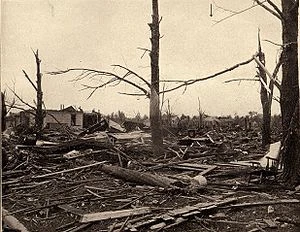
During the afternoon and into the evening hours of October 11, 1959, one of the largest October tornado outbreaks in United States history caused significant damage from the Deep South northward to the Great Lakes region, particularly in Alabama, Indiana and Ohio. Among the tornadoes included a F4 tornado that struck areas north of Birmingham, Alabama that evening, as well as one of the most violent October tornadoes on record, being rated a F5, that struck areas around Auburn, Indiana and east towards West Unity, Ohio, causing widespread extensive damage along it's entire track through northeast Indiana and northwest Ohio. In addition, the latest violent (F4/EF4+) tornado on record in the calendar year in Michigan struck areas around Saline that night, causing catastrophic damage that was reportedly of near F5 intensity at several locations, although it was rated a F4.
Meteorological synopsis
Well-above average to near-record warm temperatures had been recorded over the days prior to the outbreak in the Ohio River Valley region, with Fort Wayne, Indiana setting a new October record high of 93 on October 9, although the temperature had decreased to the high 80s to locally around 90 on October 10. On the morning of October 11, a unusual setup was denoted over the eastern United States, defined by a powerful low pressure system stationed over the Dakotas, in addition to a vast warm and unstable air mass expanding from the Gulf of Mexico to southern Ontario. Temperatures on October 11 were described as being more comfortable compared to the last few days, with Fort Wayne's temperature only climbing to 82 by that afternoon, compared to 89 the previous day, and a record-breaking 93 the day before that.
A cold front originating from the area of low pressure tracked eastward that afternoon, interacting with a large and very unstable air mass, allowing for thunderstorms to initiate from the Gulf of Mexico all the way northward to Lake Michigan, and it's believed that numerous discrete or semi-discrete supercelluar structures developed along this cold front, and the very unstable and favorable atmosphere in place allowed for numerous tornadoes to drop from Mississippi northward towards Wisconsin and Michigan, and several violent tornadoes also occurred as part of this outbreak, mostly in the Southeastern United States and Ohio River Valley, although a violent tornado struck areas west of Detroit in Michigan and was rated a F4. One particularly intense thunderstorm, believed to have been a supercell, dropped several strong to violent tornadoes across northern Indiana and northwestern Ohio before moving over Lake Erie, and it wouldn't survive the trip across the lake. Among the tornadoes produced by this storm included a F3 tornado that struck the Pierceton, Indiana area, as well as the strongest tornado of the outbreak, a F5 tornado that tracked over 50 miles from west of Auburn, Indiana to northeast of West Unity, Ohio, causing great devastation and loss of life along it's entire track. Another long-lived supercell thunderstorm produced 5 tornadoes, all of them strong and 4 of them long-tracked along a 280 mile journey from west of Covington, Tennessee to southwest of Raywick, Kentucky, with the tornadoes produced by this storm covering a total of 235.4 miles of ground during this time. Yet another tornado family produced several F3-F4 tornadoes in Alabama and Georgia that evening, causing 19 deaths along it's track. However, tornado activity largely came to a end by that night, and although a few isolated tornadoes continued into October 12, no notable activity occurred.
Confirmed tornadoes
| Confirmed Total |
Confirmed F? |
Confirmed F0 |
Confirmed F1 |
Confirmed F2 |
Confirmed F3 |
Confirmed F4 |
Confirmed F5 |
| 51 | 3 | 1 | 19 | 10 | 9 | 8 | 1 |
October 11 event
| Iowa | |||||
| F? | Center Point | Linn | 0915-0919 | 6.08 miles | A narrow tornado was reported in the Center Point area from a isolated morning thunderstorm, causing some structural damage and flipping a car. One person was injured. |
| Illinois | |||||
| F1 | Watseka | Iroquois | 1829-1833 | 5.26 miles | A cone tornado struck the town of Watseka, removing the roofs from several houses and downing around a dozen trees. First tornado produced by a long-lived cyclic supercell thunderstorm that produced several strong to violent tornadoes in northern Indiana and northwestern Ohio. |
| F0 | Near Ogden | Champaign | 1844-1845 | 1.92 miles | A rope tornado struck several houses near Ogden, producing some structural damage, although most damage was minimal. |
| F1 | Near Collison | Vermilion | 1923-1927 | 5.01 miles | A tornado touched down several times in the Collison area, producing moderate to locally significant structural damage. 3 people were injured. |
| Tennessee | |||||
| F4 | Covington to Bells to Cedar Grove | Tipton, Haywood, Crockett, Madison, Henderson | 1859-2047 | 68 miles | 36 deaths - See section on tornado here. Longest lived and longest tracked tornado of the outbreak, this tornado caused widespread significant damage in western Tennessee and wiped several communities off the map. |
| F2 | Near Somerville | Fayette | 1919-1925 | 5.97 miles | A tornado touched down several times near Somerville, heavily damaging or destroying a dozen houses. Originally rated F4, later downgraded to F2 after extensive reanalysis. 1 person was severely injured and another was initially reported killed, although this was later found to had been falsely attributed to this tornado in place of the Covington-Bells-Cedar Grove F4 further north. |
| F3 | Martin to Near Lynnville, Kentucky | Weakley (TN), Graves (KY) | 1928-1950 | 24 miles | 3 deaths - A long-tracked, long-lived and significant tornado initially touched down over the southwestern edge of Martin, just off of Baker Road. It quickly moved northeast and intensified as it crossed State Route 43 and later US Route 45, tearing a path of destruction through the heart of the city, before turning northeast in rural areas northeast of Martin and crossing the Obion River, causing significant tree damage and ground scouring along it's entire path, suggesting that the tornado was violent (F4+) at this point in time. It eventually crossed into Kentucky east of Dukedom, and began to weaken over rural areas, lifting near Lynnville. Three people were killed in the Martin area by this tornado. |
| F1 | Jackson | Madison | 2003-2005 | 1.82 miles | A cone-shaped tornado moved through the heart of the city of Jackson, producing moderate structural damage along it's path, indicative of F1 intensity. One person was severely injured. |
| F2 | Huntingdon | Carroll | 2019-2030 | 8.88 miles | A large tornado struck areas around Huntingdon that afternoon, destroying several houses in the area, and severely injuring over two dozen people. Despite the high amount of severe injuries, no one was killed. |
| F3 | Near Holladay to Tennessee City | Benton, Decatur, Dickson | 2057-2139 | 42.7 miles | 2 deaths - See section on tornado here. Second long-tracked tornado produced by long-lived supercell thunderstorm across Tennessee and Kentucky, this tornado produced significant damage across areas northwest of Nashville, and killed 2 people. Originally rated F4, later downgraded to F3. |
| F4 | Charlotte to Greenbrier to Portland | Dickson, Cheatham, Robertson, Sumner | 2159-2310 | 54.9 miles | 8 deaths - See section on tornado here. Third long-tracked and second violent tornado produced by long-lived supercell thunderstorm across Tennessee and Kentucky, although it may have been a tornado family, this tornado produced severe damage along a nearly 60 mile swath of area across north central Tennessee north of Nashville, and killed 8 people. Extreme damage was reported in the Greenbrier area, which initially resulted in a rating of F5, although this was later downgraded to F4. Last tornado of the outbreak in western Tennessee. |
| F3 | Chattanooga to Middle Valley | Hamilton | 0219-0241 | 15.5 miles | 1 death - A significant nighttime tornado struck the Chattanooga area, moving just east of downtown at F2 to F3 intensity, while killing one person. From here it continued north, causing near-F4 damage in spots, before rapidly weakening as it neared Chickamauga Lake, lifting southeast of Middle Valley. Originally rated F4, later downgraded to F3. |
| Indiana | |||||
| F1 | Remington to Near Wolcott | Jasper, White | 1951-1959 | 6.83 miles | A tornado touched down several times in the Remington area, causing some structural damage. One house was initially reported completely obliterated, although it was later found that a tree had fallen onto a structurally unstable part of the house, causing it to collapse. Rated high-end F1, although it is disputed for F2. |
| F3 | Rensselaer to Francesville to Winamac | Jasper, Pulaski | 2004-2039 | 32.2 miles | 14 deaths - See section on tornado here. A destructive and deadly long-tracked tornado caused significant damage in northwest Indiana, obliterating houses in and around Francesville, with houses being reportedly removed from their foundations and swept away, although these reports were over-exaggerated by quite a bit. Rated F3, initially rated F4. First long-tracked tornado on Watseka, Illinois-Princeton, Indiana-West Unity, Ohio-Monroe, Michigan supercell. |
| F2 | Jasper | Dubois | 2010-2018 | 7.58 miles | A strong tornado moved through the heart of Jasper, causing substantial structural damage in the city, and widespread near-F3 damage was reported. Despite reports of obliterated houses in spots and little advance warning, no one was killed, and only three people were hospitalized due to their injuries. |
THIS IS A WORK-IN PROGRESS!